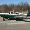
NickG Posted September 11, 2024 Report Posted September 11, 2024 Flew IFR back to Vegas yesterday from Hawthorne. Route took me right through the smoke from the fires. Zero vis and thick smoke for nearly an hour. Finally cleared around GOFS, but but my head was pounding (despite being on O2) and I started feeling bad. Diverted to KIFP. Pictures speak for themselves. Plane covered in ash. Wife had to drive 1 1/2 hrs to pick me up. Luckily, a friend will fly me back to IFP on Saturday to pick up the O. 1 Quote
IvanP Posted September 11, 2024 Report Posted September 11, 2024 Flying in smoke is no fun. Not good for you or the engine (check the air filter). We had fair amount of smoke in NorCal last few years. If able, I try to fly over the smoke or change the route. How high was the top of the smoke layer? Quote
NickG Posted September 11, 2024 Author Report Posted September 11, 2024 Up to 18 or so according to ATC Quote
NickG Posted September 11, 2024 Author Report Posted September 11, 2024 1 hour ago, IvanP said: Flying in smoke is no fun. Not good for you or the engine (check the air filter). We had fair amount of smoke in NorCal last few years. If able, I try to fly over the smoke or change the route. How high was the top of the smoke layer? Honestly, in retrospect, I should have diverted sooner. By the time I asked for a higher altitude, I would have been out of it before reaching the top. Probably not my finest example of ADM. 4 Quote
BlueSky247 Posted September 11, 2024 Report Posted September 11, 2024 That's scary stuff! I wonder if ATC would have been able to get you a reasonable re-route. Quote
NickG Posted September 11, 2024 Author Report Posted September 11, 2024 4 minutes ago, BlueSky247 said: That's scary stuff! I wonder if ATC would have been able to get you a reasonable re-route. By the time I asked, the shortest route out was the one I was on. I had no idea the smoke area was that large or that high. I need to go back and see what I missed on the Leidos brief. As I mentioned, there had to be a better way to fly it than what I ended up doing. I may need to go back and re-examine how I look at weather briefs. I'm usually overly conservative, but this was a mistake. Luckily made it through ok. Plane will be ok (I'll need to clean out induction air filter). 1 Quote
IvanP Posted September 11, 2024 Report Posted September 11, 2024 2 minutes ago, BlueSky247 said: That's scary stuff! I wonder if ATC would have been able to get you a reasonable re-route. They are usually pretty good with that. I changed routes few times on account of smoke and never had any pushback from ATC. To the contrary, they were quite helpful in finding routes and altitudes with minimal exposure. 1 Quote
201Mooniac Posted September 11, 2024 Report Posted September 11, 2024 3 hours ago, NickG said: I need to go back and see what I missed on the Leidos brief. Over recent years of fires I've found the Leidos brief insufficient for accurately identifying smoke location. I find the data available on Windy to be more helpful. I've tried to stay visual whenever possible but that can be tough as well when it is as widespread as it gets from some of these large fires. 1 Quote
LANCECASPER Posted September 11, 2024 Report Posted September 11, 2024 This webpage is really to encourage you to buy a car wash but the points made are valid when it comes to engines and paint: https://www.autowashco.com/post/how-smoke-can-damage-your-paint This has more to do with turbines however the principles still apply to us to a certain degree because of the abrasive action: Quote
NickG Posted September 11, 2024 Author Report Posted September 11, 2024 1 hour ago, LANCECASPER said: This webpage is really to encourage you to buy a car wash but the points made are valid when it comes to engines and paint: https://www.autowashco.com/post/how-smoke-can-damage-your-paint This has more to do with turbines however the principles still apply to us to a certain degree because of the abrasive action: I spoke with my A&P today. He said that wildfire ash is generally not abrasive (a la volcanic ash). He said occasional flight through this will not cause any damage. However, he said I should blow out the induction air filter. Now I've got to figure out how to do that! Quote
Ragsf15e Posted September 11, 2024 Report Posted September 11, 2024 7 minutes ago, NickG said: I spoke with my A&P today. He said that wildfire ash is generally not abrasive (a la volcanic ash). He said occasional flight through this will not cause any damage. However, he said I should blow out the induction air filter. Now I've got to figure out how to do that! You will find the aviation weather briefings insufficient to avoid smoke. I’ve flown around and over and through it a lot the last few years between Spokane and Reno. I also fly a corporate plane and I can get over it in that, but it does sometimes go to 18,000 feet. I have shot approaches to mins and barely broke out when the vis is really bad. In the Mooney, it’s terrible because all the smoke is in your lungs as well. Here is a link to NOAA smoke maps and you can get a pretty good idea of where the smoke will be, but you really won’t know how high it is unless there are PIREPS. https://apps.gsl.noaa.gov/smoke/# Quote
NickG Posted September 11, 2024 Author Report Posted September 11, 2024 10 minutes ago, Ragsf15e said: You will find the aviation weather briefings insufficient to avoid smoke. I’ve flown around and over and through it a lot the last few years between Spokane and Reno. I also fly a corporate plane and I can get over it in that, but it does sometimes go to 18,000 feet. I have shot approaches to mins and barely broke out when the vis is really bad. In the Mooney, it’s terrible because all the smoke is in your lungs as well. Here is a link to NOAA smoke maps and you can get a pretty good idea of where the smoke will be, but you really won’t know how high it is unless there are PIREPS. https://apps.gsl.noaa.gov/smoke/# Thanks - I consider myself a careful planner and quite conservative. This was my first foray into something this big. In retrospect, I also think I was suffering a small dose of get there itis combined with concern about the howling winds throughout Las Vegas on my arrival (which didn't happen due to the diversion). I've been told by another pilot that flew the area that the smoke tops were at 22k. and I would have had to make a multi hour detour to fly around it. I probably should have just kept the plane at Hawthorne and hopped on a Southwest to get home. Come back a couple days later and pick up the O. Luckily, nothing other than a dry throat and a dirty plane to serve as a reminder (although my buddy will fly me back to IFP on Saturday to pick up the plane). The outcome could definitely have been worse. 3 Quote
EricJ Posted September 11, 2024 Report Posted September 11, 2024 19 minutes ago, NickG said: I spoke with my A&P today. He said that wildfire ash is generally not abrasive (a la volcanic ash). He said occasional flight through this will not cause any damage. However, he said I should blow out the induction air filter. Now I've got to figure out how to do that! Do you know what type of filter you have? If it is a paper filter just remove the filter and take some low-pressure compressed air (or high pressure sprayed from a longer distance) and blow out the dust forcing air from back to front. If you have access to compressed air, just use a common blower fitting and shoot it at the filter. I just do it from a bit of a distance to not damage the filter media. Depending on how dirty it is, sometimes you see the crud blow out of it. An easy inspection is to just hold the filter up to a bright light source, or even the sun, and you should be able to see light through the pleats. Do that before and after and you blow it clean and see if you tell any difference. If you have a bracket filter (oiled foam), don't blow it out, just order replacement media and replace it. If you have a K&N or a Challenger, there are manufacturer directions for cleaning (or just replace it with a paper filter). I'm not sure what all the filter options are for an M20R, but that's the general idea. Quote
NickG Posted September 11, 2024 Author Report Posted September 11, 2024 23 minutes ago, EricJ said: Do you know what type of filter you have? If it is a paper filter just remove the filter and take some low-pressure compressed air (or high pressure sprayed from a longer distance) and blow out the dust forcing air from back to front. If you have access to compressed air, just use a common blower fitting and shoot it at the filter. I just do it from a bit of a distance to not damage the filter media. Depending on how dirty it is, sometimes you see the crud blow out of it. An easy inspection is to just hold the filter up to a bright light source, or even the sun, and you should be able to see light through the pleats. Do that before and after and you blow it clean and see if you tell any difference. If you have a bracket filter (oiled foam), don't blow it out, just order replacement media and replace it. If you have a K&N or a Challenger, there are manufacturer directions for cleaning (or just replace it with a paper filter). I'm not sure what all the filter options are for an M20R, but that's the general idea. I have the paper filter. 1 Quote
EricJ Posted September 11, 2024 Report Posted September 11, 2024 8 minutes ago, NickG said: I have the paper filter. If you know exactly what you have, or at least the manufacturer, there is probably a product manual that you can download that will have cleaning instructions. For a Donaldson filter, for example, it's usually just to blow air through it. Quote
dkkim73 Posted September 12, 2024 Report Posted September 12, 2024 I just flew to western Montana this Sunday, south of Missoula. There have been multiple fire TFRs and I have had to go around them in the recent past when they blocked some instrument approaches, vectored until in a position to do a visual (or a contact approach technically a couple weeks ago). Limited visibilty due to haze. The first time I called the coordinating facility and discussed the situation to get some awareness. On Sunday, I figured it would be the same... they told me to expect the instrument approach... I queried to verify no TFR conflict. I got a clearance and descent, then a forget-that-hold-and-wait while they got a jet off. Then another. At this point, approaching the area, I realized I couldn't see any of the usual mountains due to smoke and more so haze...the clouds being fairly high. I slowed in anticipation and eventually got kind of a slam-dunk onto the initial (often an issue due to enroute terrain), which sped things up. Anyhow, it felt a lot more "real" than usual since I really did have obscured mountains, no visible horizon, limited fwd visibility, and the usual issues with losing speed and altitude in a Mooney. Compounded it by hitting the wrong switch, but took over manually and re-coupled after some careful review. What surprised me most was not seeing the runway until about 100-150ft above circling minima! I'd briefed the miss twice before that point as a matter of practice, so I was thinking, wow I'm actually going to go missed with a 10,000ft ceiling... It was uncanny how the slant range visibility was reduced, the intuition was different than clouds. This was in the context of having moderate familiarity with the area and landscape cues. Maybe not a surprise to those who fly these conditions a lot, but a caution to those more accustomed to dewpoint-related obscuration. 1 Quote
Hank Posted September 12, 2024 Report Posted September 12, 2024 4 hours ago, dkkim73 said: I realized I couldn't see any of the usual mountains due to smoke and more so haze... Anyhow, it felt a lot more "real" than usual since I really did have obscured mountains, no visible horizon, limited fwd visibility, and the usual issues with losing speed and altitude in a Mooney. Glad everything went well! You're now ready for summertime flying in the Appalachian Mountains. I've been flying on a CAVU day, no clouds for hundreds of miles, and had total whiteout on descent for several thousand feet before hilltops became visible through the murk, then suddenly visibility came back. Haze is real! My only western fire experience was missing the chance to go flightseeing over Yellowstone due to Fire TFRs. Flying in that much smoke sounds unpleasant. Quote
Skates97 Posted September 12, 2024 Report Posted September 12, 2024 You may have done much better going VFR, staying west of Mt Baldy and then east skirting the edge of the restricted areas and MOA's. The direction the wind is carrying all the smoke you went right through the worst of it. I've been watching that one and the Line Fire just east of the Cajon Pass with a trip planned to ID in a week and plan to go on whichever side of the fire is on the upwind side. 2 Quote
NickG Posted September 13, 2024 Author Report Posted September 13, 2024 5 hours ago, Skates97 said: You may have done much better going VFR, staying west of Mt Baldy and then east skirting the edge of the restricted areas and MOA's. The direction the wind is carrying all the smoke you went right through the worst of it. I've been watching that one and the Line Fire just east of the Cajon Pass with a trip planned to ID in a week and plan to go on whichever side of the fire is on the upwind side. Yes. Agree. I didn't have the full picture of how large the fire was. Quote
Z W Posted September 13, 2024 Report Posted September 13, 2024 The smoke caught me by surprise a couple of years ago on a trip to Montana as well. Had not really planned on any weather because none was in the forecast, then suddenly visibility dropped and I had to fly an approach into Casper, WY because it was reporting 1 mile visibility with unlimited ceiling. The runway came into view 3 miles out. Plane was covered in a film of dirty grit when we landed. If I remember right, the fires were several hundred miles away in Canada somewhere. Something to be aware of flying out west that I'd never encountered before, and I agree, available weather briefings don't always identify the hazard. 1 Quote
Ragsf15e Posted September 13, 2024 Report Posted September 13, 2024 On 9/11/2024 at 11:48 PM, dkkim73 said: I just flew to western Montana this Sunday, south of Missoula. There have been multiple fire TFRs and I have had to go around them in the recent past when they blocked some instrument approaches, vectored until in a position to do a visual (or a contact approach technically a couple weeks ago). Limited visibilty due to haze. The first time I called the coordinating facility and discussed the situation to get some awareness. On Sunday, I figured it would be the same... they told me to expect the instrument approach... I queried to verify no TFR conflict. I got a clearance and descent, then a forget-that-hold-and-wait while they got a jet off. Then another. At this point, approaching the area, I realized I couldn't see any of the usual mountains due to smoke and more so haze...the clouds being fairly high. I slowed in anticipation and eventually got kind of a slam-dunk onto the initial (often an issue due to enroute terrain), which sped things up. Anyhow, it felt a lot more "real" than usual since I really did have obscured mountains, no visible horizon, limited fwd visibility, and the usual issues with losing speed and altitude in a Mooney. Compounded it by hitting the wrong switch, but took over manually and re-coupled after some careful review. What surprised me most was not seeing the runway until about 100-150ft above circling minima! I'd briefed the miss twice before that point as a matter of practice, so I was thinking, wow I'm actually going to go missed with a 10,000ft ceiling... It was uncanny how the slant range visibility was reduced, the intuition was different than clouds. This was in the context of having moderate familiarity with the area and landscape cues. Maybe not a surprise to those who fly these conditions a lot, but a caution to those more accustomed to dewpoint-related obscuration. Yes, I’ve noticed the TAF doesn’t do a good job of taking smoke into account and the sensors don’t seem to match flight visibility very well for METARs either. I’ve had that same experience of shooting an approach to 3/4 mile vis mins while the TAF and metar said I shouldn’t even be close to mins. Never mind all the crap we’re breathing while doing it… 1 Quote
N201MKTurbo Posted September 13, 2024 Report Posted September 13, 2024 I was flying back from Hillsboro OR a few years ago. I had planned a fuel stop in Carson City NV. The TAFs said clear skies. When I got there all the airports in the area were below IFR minimums because of smoke. So I continued south, there were a few more airports along the way. as I approached them they too went below IFR minimums. I was finally able to land at Bishop CA. I only had 4 gallons of fuel on board when I landed. Not good. 3 Quote
Skates97 Posted September 13, 2024 Report Posted September 13, 2024 6 hours ago, Z W said: The smoke caught me by surprise a couple of years ago on a trip to Montana as well. Had not really planned on any weather because none was in the forecast, then suddenly visibility dropped and I had to fly an approach into Casper, WY because it was reporting 1 mile visibility with unlimited ceiling. The runway came into view 3 miles out. Plane was covered in a film of dirty grit when we landed. If I remember right, the fires were several hundred miles away in Canada somewhere. Something to be aware of flying out west that I'd never encountered before, and I agree, available weather briefings don't always identify the hazard. 1 hour ago, Ragsf15e said: Yes, I’ve noticed the TAF doesn’t do a good job of taking smoke into account and the sensors don’t seem to match flight visibility very well for METARs either. I’ve had that same experience of shooting an approach to 3/4 mile vis mins while the TAF and metar said I shouldn’t even be close to mins. Never mind all the crap we’re breathing while doing it… TAF, METAR, AWOS all don't do well with smoke. They just don't see the particulates. A few years back we were making a fuel stop in Tracy, CA and it was reporting 10miles and clear skies. On approach you could see the ground and runway ahead, until you were in the smoke layer and couldn't see anything for a minute. On the ground you could look up and see bluish sky but climbing out there was again a period where forward visibility went to almost zero even though you could still see the ground off to the side. As has been mentioned, with smoke it's always preferable to stay VFR. If you fly out West (or live in fire danger areas) there's a great App called Watch Duty that sill show you all the fires, their size, evacuation zones, etc... Helps to get a picture of where the fires are and their size. That Bridge Fire that @NickG flew through is now almost 52,000 acres and when he made the flight it was already over 20,000k acres. I took a similar picture to the one he posted on my way home from work on Tuesday. Everything to the right of the fire is smoke... They really put out an immense amount of smoke that travels hundreds of miles. This was the Airport Fire in south Orange County seen from work on Tuesday. At this point it wasn't even very big yet, I think just around 5-6,000 acres but almost looks like a volcano. I have an incredible amount of respect for the guys that fly the tankers and helicopters dropping on these monsters. 2 Quote
NickG Posted September 13, 2024 Author Report Posted September 13, 2024 I'm definitely going to make fire/smoke ID a part of my preflight planning, especially when flying in and out of California. The final leg of my flight will be Saturday when my friend will fly me down to KIFP to pick up the beloved O so I can fly it home to HND and a WASH (lol). Quote
Recommended Posts
Join the conversation
You can post now and register later. If you have an account, sign in now to post with your account.