Search the Community
Showing results for 'Windy.com'.
-

planning VFR x-country flight in this crazy summer weather
GeeBee replied to dominikos's topic in Miscellaneous Aviation Talk
I've done across the continent trips in the summer in VFR only airplanes. My last was SEA to ATL in a SuperCub in August. The advice given above is sound. Leave at sunrise, don't plan on flying much past 1300LT. Even if you had an IFR rating, it don't work in convective weather without radar. Onboard weather is a must. Use it strategically, not tactically, remember the data can be up to 20 minutes old. I find the Hotels.com app really handy on such trips. You can find something pretty fast when you get shut down unexpectedly and their rewards program is better than any other chain's program. Give yourself some extra days, remind your daughter it is not the destination but to have fun getting there. As the old saying goes, "Have time to spare? Go by air!" That all said, the weather really sucks right now. A lot of moisture coming up from the gulf. I use a variety of sources as mentioned above for long range (greater than 72 hours) "looks in the future". For a "big picture" look at destinations I like the 10 day forecast on WeatherUnderground.com. As mentioned windy.com does a good job at refining that look. If it looks like a total bust fine, take the big tube, just remember anything beyond 72 hours is really quite a guess. -

planning VFR x-country flight in this crazy summer weather
cliffy replied to dominikos's topic in Miscellaneous Aviation Talk
Try looking at windy.com about 5 or so days out Windy gives pretty good info on what might happen Easy to learn how to manipulate the controls -
Thanks, Anthony. That shows my options. Direct route will be almost straight downwind but over some tall rocks in gusty winds that I'd reach at about 10:30 a.m. Windy.com says winds at FL100 along my route will be greater than 30 knots in places; the tops of the tallest rocks along the route are at about that level. I can be over 12,500 pressure altitude for 30 minutes (to give me some margin between me and the rocks). Surface winds at WYS will be somewhere between 9 gusting to 16 and 16 gusting to 26. I've left WYS heading to Montana in windy, gusty conditions, and it's not something I'd like to do with passengers. Billings, in contrast, is expected to be between 6 gusting to 8 and 6 gusting to 11, but Cody, which is in the valley south of Billings, is expected to be between 7 gusting to 15 and 12 gusting to 23, so not much better than WYS, although if I go through Cody I've got mostly lower elevation between me and Lewiston rather than the rocks that are north of WYS. So the eastern option gives me almost as much wind but flatter, lower terrain. My guess is I'm going to have moderate turbulence either way. I think the eastern route might be wiser, but I'd value advice from locals. By the way, Cody might be gusting to 41 at 6 p.m. on Thursday.
-
I know it’s on the checkride. im kind of already used to the winds concern as a glider pilot. You don’t fly gliders in calm air. Windy.com plans your week.
-
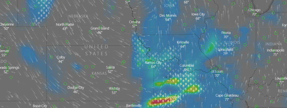
I've upgraded from a M20C to a M20M Bravo. I want to be careful of not over estimating the new airplane or my abilities, so I'd like the groups thoughts. In particular those that commonly fly in weather, IMC, TKS, O2, etc. I'm planning a trip from Indianapolis to Denver this week leaving Wednesday and returning Saturday. Looking at a site like windy.com I can see that winds across the route will be high (10-20kts at the surface), so choosing good runway alignment for a fuel stop is important. Moreover there could be turbulence, how much at the flight levels? There are also some thunderstorms forecasted along the route. Would a northern route work? How comfortable would you be planning this and picking through this? Looks like southern Iowa would work. With this type of forecast would you typically be able to pick through at 18K ft? The images below are at 1pm (ET), my planned departure. For those wanting to go through the scenario, it gets worse later in the afternoon. Making me thing the development of these storms poses increasing risk on Wednesday. (also seen in the extended convective forecast from NOAA) Return on Saturday look ok if it is late...after the next system moves through Indy. I'd really appreciate everyone's thoughts. I've done a lot of trips with weather in the M20C, and I like the M20Ms ability to get higher, but I don't know that is going to give me much of an advantage the way this storm is shaping up. Moreover I can't leave until the afternoon, so getting out early isn't helpful. FWIW, I bought a ticket to fly commercially as I don't like the way this is looking and need a good plan A. Plan B is to fly myself at this point, looking for your thoughts.
-
Windy.com shows model predictions of the future. It shows model outputs for the next 9 days for both ECMWF and GFS models. The ICON model output goes 5 days into the future, while the NAM goes out 3 days. That's its real utility. You can see synoptic (large scale) features out up to 9 days in advance.
-
It’s been around a few years... Some people get good use out of it... https://mooneyspace.com/search/?q=Windy.com&quick=1 Best regards, -a-
-
Picked it up in 2017... after reading about it on MS... https://mooneyspace.com/search/?q=Windy.com&quick=1 -a-
-
Learned about this in glider school. Its a pretty cool website to visualize wind forcastes. Its interesting to see why two airports not far apart have different winds. I've found its very accurate. -Robert
-

Urgent PIREP for icing from M20P
exM20K replied to Scott Dennstaedt, PhD's topic in Miscellaneous Aviation Talk
Yowza! I elected to hop on the germ tube for a Chi->DFW three-day meet this past monday. The PAX I was to pick up nearby had the flu, the weather mid-week looked challenging, and I *had* to be back Thursday. That's an easy three strikes. One of the biggest go/no go challenges I find is mid-range icing forecasts (2-3 days). I wound up looking the soundings model forecasts on Windy.com. I'd probably benefit from the live seminar in this area. Will you be doing any live seminars again? Or is there one of the for-sale webinars on your site that would cover this? -dan -
I use windy.com to get a feel for the likely weather conditions for a flight. One thing to note is that windy.com allows visualization of the output of four different models: European Center for Medium Range Weather Forecasting (ECMWF), NOAA Global Forecast System (GFS), NOAA North American Forecast System (NAM), and newly the German DWD Icosahedral Nonhydrostatic (ICON) models. There are raging debates about which model is "best". I'm not going to get into that. The answer varies over time and by variable (temperature, ceiling, etc.) However, when it is your a$$ on the line and you need a good wx decision, compare the output of the different models for the flight time and see how closely they agree. Agreement between the different models provides some indication of likely weather conditions. Disagreement between the different models adds uncertainty to your decision making process. These models have different resolutions, forecast horizons, and capabilities. I don't think looking at windy.com replaces a weather briefing, because it doesn't show important things like turbulence. Rather I see it as a nice add-on to a briefing. A final note. Calling a model "accurate" is never appropriate. All models are approximations and never perfect. The ECMWF and GFS models for instance run on grid sizes 0.28 degrees (~31 km) and half degree (~30NM), respectively. ICON runs on a 13 km triangular mesh. If the model forecasts a frontal boundary location near your destination, it could easily be many grids off, which is a long distance. A meteorologist would say that the model perfectly forecast the arrival of the front within a 2-hour window, when I a pilot might arrive as the front is passing when the models said it would not. I am a modeler. I work in affiliation with NOAA, but do not represent NOAA. I'm skeptical of all models. Trust them when it is easy (high pressure dominating). Doubt them when there is reason to doubt.
-
Friday I thought about making a round trip flight from Tuscaloosa, AL to Laramie, WY, going west Saturday and returning today to rescue a son who is stuck at a college that has canceled classes. The forecast I saw Friday night for today's weather made it a no-go for me. Looking at your screen cap, the models were pretty close and it seems that they helped me make a good call because freezing level interactions in precip or clouds would be impossible to avoid along the route. Remember the radar beam gets higher off the surface the further you get away from the radar. Out in your part of the country the radars are pretty far apart so they don't do a good job of showing you where ice might be a problem. Ice in any form just can't be messed with in our planes. About three weeks ago on an IFR practice flight here in AL I encountered freezing rain at 7000 with my outside air temperature sensor which mounted in the wing about 30" outboard from the cabin indicating that it was above freezing (+1C). It happened really fast and accumulated much quicker than I would have thought with an airframe that is above freezing. Windy.com shows modeled freezing levels. Those models are initialized using the twice-daily weather balloon data so they have some validity and are quite good. Remember, clouds below freezing can still be supercooled water drops. Any time you go into a cloud and the temp. is less than 0C, keep an eye out for ice accumulation on the leading edge. Picked this up in about 120 seconds after I penetrated a cloud layer at 8000 over Little Rock, AR in Feb. I knew that the tops were about 8,500, so I asked for higher and got above the clouds. A Cirrus trying to climb up through the clouds after taking off from Little Rock was picking up enough ice that he told the controller that he was unsure if he was going to be able to climb through it. He made it. I'd just say that until you get more experience, avoid anything that looks like a freezing level interaction . Wait until it warms up to spread your IFR wings. Be a chicken.
-
Focus should be on the big wx picture
PaulM replied to Scott Dennstaedt, PhD's topic in Miscellaneous Aviation Talk
Scott, Part of this is that you are a Meteorologist, and will analyze those charts. Most pilots are tactical and want the post analysis data. I usually start about a week out with windy.com and the ECMWF model. I'm looking for the projection of fronts and low clouds/IFR. on my targeted travel days, to see if I need to move the travel date +/- 1 day. I then watch this solidify over the week as the timing of the frontal movement gets clearer. Once we are within 48 hours I'm pretty set with what we will get, and look then only for problems with T-storms and icing, IFR minimums and alternates for the flight. I'll use windy and the MOS product. The FAA/NOAA forecast products are very vague... if they show no precipitation, you can be sure there is nothing there.. but you will have large areas of forecast rain, and possible rain, that are over broad.. Within 24 hours the TAF's now give you local knowledge for the terminal forecast. Once we are within 12 hours, the ICP products are valid, and the GFA, and Flight path tools can be used. This allows me to finalize the icing decision, look at cloud layers and skew-t. I'll finalize the route and optimize the height for winds, cloud layers etc.. and execute. Examples: I was in Denver for Christmas, and there was a snow storm forecast, by Wednesday I knew that we had to get out a day earlier (Friday) to beat the storm and picked a destination (Ohio) that would be beyond the affected area. The 12 hour forecast showed freezing fog, and possible light icing in the lower clouds.. So I planed for right at that minimum (FIKI), and would be out soon to the east. Weather was clear, we were above a layer and had no issues. Last year on the way to Florida, there was a front forecast stretching from WV to the coast with freezing levels to the MEA and other things in the mountains, but what looked like the 100miles to the coast were clear in the morning, with the freezing level above 6000' and just a stretch of IFR weather. This worried me, but it was over 12 hours so I didn't have the ICP products yet. On Friday morning, I ran the OGIMET analysis for the next day, and it showed me what I was missing, it was snow above 6000'.. descending into warmer weather, and therefor freezing rain. I moved up the departure to that afternoon, and flew down to Grand Strand which would be south of the front, and completely bypassed the icing threat. An easy IFR flight to FL the next morning. I'm planning this year's flight down to FL... 1 week out it was showing a front from the SE across the Carolinas. By T-5 that forecast front had moved on beyond the coast for Saturday, and I'm seeing easy VFR until south Florida and perhaps a simple IFR letdown at my destination. With that forecast there isn't much more to do until the final morning to adjust for winds, and morning fog, and looking at the cloud layers for the final IFR planning. -
I had ~50 knots on the nose yesterday at 6500 feet heading NW out of Richmond, which worked out to 114 kts ground speed. It was nice a smooth, but slow. Flipped a 180 and ground speed jumped to 214 knots... Friend on mine went from Detroit to just south of D.C. in his V35B with IO550 and Flightaware had him at 244 kts ground speed at 9,000 which was ~74 knot tailwind. For once, it worked out for him... It's always fun checking out what's happening via the Windy website. https://www.windy.com/?900h,41.870,-98.262,4 Cheers, Brian
-

Weather-guessing 2-3 weeks in advance?
Mooney in Oz replied to PJClark's topic in General Mooney Talk
I find windy.com to be very useful as it predicts thunderstorms, cloud cover and wind not only at surface level but also at altitude plus many other useful features in overlay pictorials. Have a play around with it. -
windy.com has three different models you can compare. The european model will give you about 10 days and has been pretty accurate for the gulf coast as to 3-5 days I decide to fly commercial vs. being fogged in.
-

NOAA MOS Extended Ceiling and Visibility No More!
SkyTrekker replied to DualRatedFlyer's topic in General Mooney Talk
I just discovered this discontinuance a few days ago, too. I used the graphical ceiling imagery all the time...sorry to see it go. As was mentioned above, windy.com (and especially, their ios app) seem to work as a decent replacement for several days-out ceiling forecasts. It did take me a few minutes to figure out how the app works. But seems to work pretty well. -

NOAA MOS Extended Ceiling and Visibility No More!
CCowboy replied to DualRatedFlyer's topic in General Mooney Talk
Get the Windy.com app or check out their website. You can get the "meterogram" at each airfield (set up airfields on the map). It will give you MOS data in a graphic form-but better. See cloud bases/tops, temps, precip, wind, etc. Have used it for about half a year and it is very good product. There is a lot of Wx data with the website/app. Play with it for a while and the map version will layer cloud coverage, bases, wind, precip, etc at any point in the US. The map can be set to use NAM, GFS, ECMWF forecasts. You can run a forecast time on the lower sliding scare and see the Wx progress. www.windy.com -

NOAA MOS Extended Ceiling and Visibility No More!
DanM20C replied to DualRatedFlyer's topic in General Mooney Talk
It’s just that graphic that NOAA produced. Garmin pilot never included that graphic in their tools. i suspect ForeFlight will either implement their own or another 3rd party soon. windy.com has some impressive tools/graphics that are based on the MOS. cheers, Dan -

The problem with better weather products
Immelman replied to ArtVandelay's topic in General Mooney Talk
Screw that, wait a day. Or take a more analytical approach: Learn from others, and then take that into account the next time this comes up. From the comfort of your living room, compare that windy forecast with the pireps in the are when the time comes. Note who is giving what type of pirep, and at what altitude. Is severe reported? Is a sigmet issued? What do the terminal forecasts give for clues: KSFO 201739Z 2018/2124 28011KT P6SM FEW030 FEW180 FM201900 32017G27KT P6SM SKC FM210000 31010KT P6SM SKC WS020/02030KT The above terminal forecast is for the area this evening... and there are a ton of moderate pireps in the area from a variety of aircraft sizes.... windy.com, 5 days out... that is a bit of a stretch, especially considering 100+ mph @ 14,000. In the next couple days the NWS will have their tools to compare things to. I would not scrub your trip yet, but look and see how things develop. -
The 6 hour Satellite loop in Windy.com shows the eye reforming it is a really large across eye at this point.
-
Just looked at the long range forecast for the Hurricane.... Using Windy.com which uses the European Model. Windy has let me down on long range tropical storm forecasting before. But it is pretty accurate on the 3-4 day and really accurate on the 1 day. Looks like Miami Area Tuesday then all of Florida, then the lower Eastern Coast. Storm offshore of Washington DC next Saturday. Texas is not too Mooney far if anyone needs a spot to keep planes, I can start looking. If the energy stays offshore of Florida and it moves up the coast that is going to be yucky. What does @scottd say?
-
Discovered this website for weather last week. Does winds clouds waves Metars and a bunch more. Take a look at it and it is FREE. Click on the orange circle to open more options. WINDY.COM Pritch
-
Huge fan of Windy.com Like you have got it down to 45 minutes to flying between storms on working our way away from the coast. It is even good at forecasting the local Brazos valley fog that the NWS struggles to know about. Here is a fun one for tonight. The NWS is the forcasting a line of storms to come through Houston between midnight and 5 am. light hail so some convection.Windy is saying not going to happen. It will be a good test.


