Scott Dennstaedt, PhD
-
Posts
457 -
Joined
-
Last visited
-
Days Won
3
Content Type
Profiles
Forums
Blogs
Gallery
Downloads
Events
Store
Everything posted by Scott Dennstaedt, PhD
-
 So it's -30°C at 15,000 feet over Boise, Idaho at the end of February. Any chance of icing at this altitude based on this Skew-T diagram?
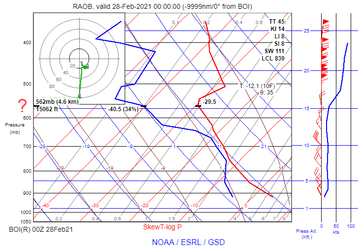
-
FWIW, I never use windy unless I am watching a possible landfalling hurricane. The interface is horrible and very hard to navigate and doesn't give me the aviation-specific information that I prefer to use.
-
Notice that I did not say that experience isn't important. Actually what works the best is having a pilot to mentor with. I do that for dozens of pilots from a weather perspective. Scaring the hell out of yourself is a BAD approach to learning. In fact, it teaches you nothing. When I hear "older" pilots say things to "younger" pilots such as, "just get out there and fly in some real weather and you will figure it out" is when I turn away and shake my head. It has and will always be a recipe for disaster. In my 40+ years, I have heard it all and have talked to thousands of pilots about weather over the last two decades. And the common thread is not the lack of experience, but it is the lack of knowledge and training. 99% of pilots are not trained properly when it comes to weather...so it doesn't matter how much experience you have, those experiences are not going to suddenly generate knowledge. So I am not disagreeing with you...but experience isn't the gold star to making good decisions...it's knowledge that leads you down the path to making the best decisions and reasonable judgement that turns into valuable experience. Why? Because every single weather system is different and to think otherwise is just an open manhole waiting for you to fall into. To think that previous successes in flight make better decisions on the next flight is just missing the point and is a dangerous mindset simply because risk is addictive. How do I know that? Because I am a student of weather and I have studied why pilots kill themselves in weather-related accidents and it's due to a lack of knowledge...I worked 3.5 years on this topic to earn my PhD. Why does a 12,000+ hour ATP and flight instructor decide to depart in an airplane without a certified ice protection system with two other people on board and attempt to climb through a stratocumulus deck loaded with ice? Did his experience protect him? No. Did his lack of knowledge defeat him? YES! See Cirrus Birmingham icing accident. And from a knowledge perspective, I'm not talking about rote memory and naming cloud types. That's not the knowledge I am speaking of. It's understanding why SHRA, VCSH and TSRA are all a form of convection. It's understanding why icing is still very likely in clouds producing snow. It's understanding that lenticular clouds are more often a sign of smooth air than not. It's knowing why a forecast for non-convective LLWS isn't a forecast for turbulence. These are the things that will allow you not to need to do a CAT III approach. These are the tools that will minimize your exposure to dangerous turbulence or airframe icing, not test the waters to gain experience dealing with them. No amount of experience is going to teach you how to do that. I don't need to have touched a hot stove to know that it will burn me. A seasoned or tempered pilot should get there through a concerted effort of education and training. So I'll stick with the NTSB's safety study which was very thorough. You don't gain knowledge simply because there are more hours in the logbook. Knowledge is needed. Education is the key to a long flying career. You read, take courses, go to seminars, and you get training from an expert. Then you apply that knowledge during your preflight planning and while in flight. That's the experience that will keep you in the game for a long, long time. That's the foundation that works, not the other way around. Experience without critical knowledge only breeds risk. Bank on it - the accident statistics scream it. And when you are ready, send me your address and I'll send you my new book on weather for you to mull over in your spare time...the knowledge contained within will make you a better pilot, guaranteed or your money back! To anyone reading this, experience is not the answer! It's knowledge and training that is backed up by experience - that is the valuable asset.
-
Wish that was true, but sadly it isn't. In fact, it's one of those many myths. Experience means nothing unless you know what you are looking at. In fact the NTSB released a safety notice in October 2005 that states, "It appears that pilots generally require formal training to obtain weather knowledge and cannot be expected to acquire it on their own as they simply gain more flight experience." Can't underscore this enough. Mother Nature doesn't care how many hours are in your logbook.
-
Okay, thanks to everyone who responded.
-
Are you going to Sun 'n Fun?
Scott Dennstaedt, PhD replied to Parker_Woodruff's topic in Miscellaneous Aviation Talk
I'll be attending, Hangar C, Booth 92. I'll also be doing 4 presentations at the education forums (dates/times are TBD). -
I will be doing a free webinar for EAA coming up in May where I will present the top 10 weather questions pilots ask. I've been an instructor for over 20 years and I've heard dozens of the same questions over and over again...but I am curious...if you had one weather question (related to aviation) that's been bugging you, what would that question be? These need to be relevant to aviation safety in some way. For example, "I see these long dashed lines on the prog charts and wondering if I should be concerned about flying through that area?" Interested to hear your questions.
-
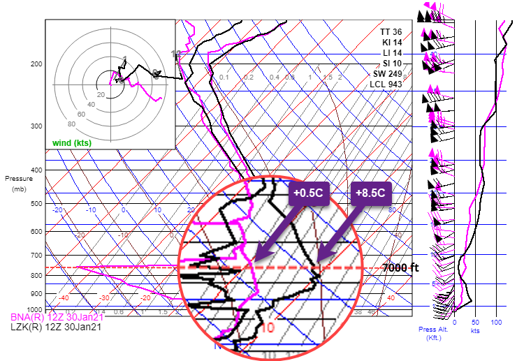
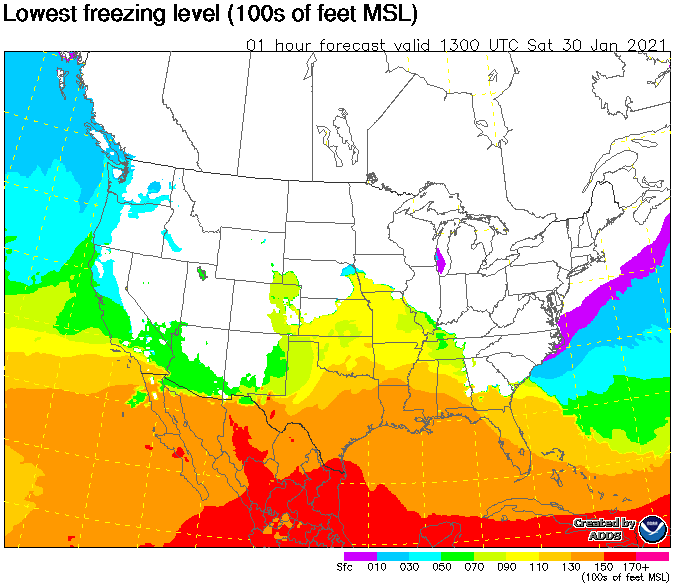
Appears there was a warm front nearby the boot heal of Missouri. So, you likely crossed over from the warm sector to the cold sector along the route. Here's the freezing level chart showing a sharp gradient in central TN. Here's the RAOB for central Arkansas (black) and Nashville (magenta). Notice the temperature drop at 7K between the two.
-
At what point in the route (some nearby airport/navaid) did you experience the temperature drop at 7K? Approximately what time was that (zulu)?
-
Would need to know the specifics...date and time (zulu) this occurred and exactly where it was observed (nearest airport and the approximate route...maybe a flightaware track).
-
A real nasty icing signature!
Scott Dennstaedt, PhD replied to Scott Dennstaedt, PhD's topic in Miscellaneous Aviation Talk
Keep in mind that the freezing rain signature they show here only accounts for about 8% of the cases. It’s the exception, not the rule. While the signature they point out is dangerous for pilots, the nonclassical case is the one that tends to not be well understood by pilots. In fact, the entire temperature profile can be below freezing and still produce freezing rain or more likely freezing drizzle. Also what is said about sleet (below) is not entirely accurate. The snowflake only partially melts and retains a slushy core. The retained core is what allows the partially melted drop to refreeze. Without that core (complete melting), the air must be extremely cold for it to "refreeze" into a pellet. Sleet is a very important indicator of SLD aloft. "As snow falls into the 'warm nose', it melts into a liquid drop/rain. Then the liquid drops fall back into the arctic air mass (near the ground) that is cold enough and deep enough for the liquid to freeze into ice pellets before reaching the ground.” For another explanation, you can read my blog here on precipitation types. -
A real nasty icing signature!
Scott Dennstaedt, PhD replied to Scott Dennstaedt, PhD's topic in Miscellaneous Aviation Talk
What you say is correct, but not what makes this so concerning. Check out my post earlier in this thread for my analysis. -
A real nasty icing signature!
Scott Dennstaedt, PhD replied to Scott Dennstaedt, PhD's topic in Miscellaneous Aviation Talk
Agreed. It was an area to avoid. -
A real nasty icing signature!
Scott Dennstaedt, PhD replied to Scott Dennstaedt, PhD's topic in Miscellaneous Aviation Talk
Dan, If you are looking at the CIP/FIP icing severity charts (found on aviationweather.gov), the SLD isn't a calibrated probability and they will add the red-hatching on the chart even if it's as low as a 5% chance. When I looked at the actual probabilities, the percentages were very low in this region. I don't have any plans to start my in-person classes back up again. They are extremely challenging to market and most pilots really don't want to pay for weather training. Sad, but true. They will pay top dollar for an engine management course since there's an immediate payback ($$$$), but becoming a safer pilot because you have more weather knowledge to minimize your exposure to adverse weather has no immediate monetary return. I tell everyone though, if you can get 20 or more people that have a serious interest in attending in your area, then I will be more than happy to travel to your location and hold one (post COVID-19, of course). I've done that on several occasions where everyone prepays for the program and basically I show up and teach. But every time someone leads the challenge and they get enough interested parties, the next challenge is for them to commit to a specific schedule and open their wallet. The cheapest part of an airplane is the nut behind the yoke. -
A real nasty icing signature!
Scott Dennstaedt, PhD replied to Scott Dennstaedt, PhD's topic in Miscellaneous Aviation Talk
In this case there was no SLD forecast, that why I posted this case. It didn’t have any SLD signature, but represented a significant threat. -
A real nasty icing signature!
Scott Dennstaedt, PhD replied to Scott Dennstaedt, PhD's topic in Miscellaneous Aviation Talk
Try reading this... -
A real nasty icing signature!
Scott Dennstaedt, PhD replied to Scott Dennstaedt, PhD's topic in Miscellaneous Aviation Talk
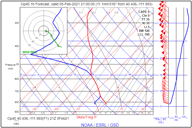
Here's what got my attention.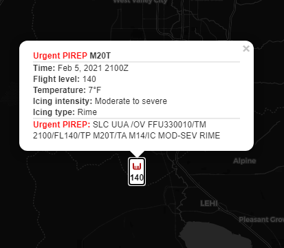
-
If you are the type of pilot that uses a Skew-T as it relates to airframe icing, here's one that you should keep in your mind to avoid. Not a good afternoon to be flying a Mooney in the SLC area.
-
Weird Foreflight Data
Scott Dennstaedt, PhD replied to AH-1 Cobra Pilot's topic in General Mooney Talk
Skip, It's likely because it's an AWOS-3. They are a piece of crap compared to an ASOS. The ASOS has much higher standards and would never generate a dewpoint temperature warmer than the temperature. Here's a nearby obs from an ASOS. METAR KOMA 041452Z 00000KT 3SM BR FEW004 SCT120 BKN250 M02/M03 A2999 RMK AO2 SLP168 I3001 T10171028 53031= Chalk it up to fake news! Here's the algorithm used by the ASOS... The current 1-minute ambient temperature is also compared against the current 1-minute dew point temperature to ensure the dew point is not higher. If the dew point temperature exceeds the ambient temperature by 2°F or less, the dew point temperature is set equal to the ambient temperature. If the dew point temperature exceeds the ambient temperature by more than 2°F, the 1-minute dew point temperature is set to “missing.” -
Weird Foreflight Data
Scott Dennstaedt, PhD replied to AH-1 Cobra Pilot's topic in General Mooney Talk
Yes, a cloud drop needs an ice nuclei to freeze. That's called heterogeneous nucleation. The nuclei needs to look remarkably similar to an ice crystal, that's why they are relatively rare compared to condensation nuclei. So ice crystals make the best ice nuclei, of course. You will get homogeneous freezing once the temps drop to below -40°C. But your airplane makes a great ice nuclei. Most non-convective clouds are glaciated at a temperature below -25°C. -
Adding FIKI to a regular ovation
Scott Dennstaedt, PhD replied to NJMac's topic in Modern Mooney Discussion
My advice for approaches or landings with ice accretion is to avoid anything that might change the angle of attack significantly. So, I avoid adding flaps and I avoid rapid airspeed changes...if you need to slow down, for example, pull back the throttle deliberately, but slowly. And if you start experiencing any sloppy feeling in the controls or feel any buffeting that is not characteristic of normal flight, then add power back. -
A New Way Forward for De-Ice?
Scott Dennstaedt, PhD replied to Rotorhead's topic in Miscellaneous Aviation Talk
I have an ice cream scoop that uses body heat in a similar way. Hmmm? I think I'll try it out after dinner tonight! -
FYI: Weather observations from the ASOS at Campo, CA, (KCZZ) will cease due to construction at the site. The ASOS equipment will be moved to a new location with a new site and identification being established.
-
Two things we are taught to avoid...thunderstorms and freezing rain. That's a bad day even when walking! KOKC 281223Z 34008KT 3SM TS -FZRA BR BKN004CB BKN008 OVC018 00/00 A3001 RMK AO2 PK WND 23028/1153 WSHFT 1157 LTG DSNT N AND S TSE06B23 FRQ LTGICCC OHD TS OHD MOV NE P0019 T00000000 $
-
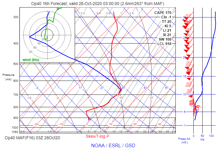
Here's your chance to show your Skew-T acuity. In this forecast sounding, what precipitation type would be expected to reach the surface based solely on the forecast below? An explanation is also required with your answer.