Scott Dennstaedt, PhD
-
Posts
459 -
Joined
-
Last visited
-
Days Won
3
Content Type
Profiles
Forums
Blogs
Gallery
Downloads
Events
Store
Everything posted by Scott Dennstaedt, PhD
-
 Greg, You are welcome. Monday and Tuesday will be very broad outlooks and should begin to set the stage for the rest of the week.
 -
Good timing here Jim... I just published my latest video with some tips for summertime preflight planning using my progressive web app, EZWxBrief. Enjoy.
-
Twins are No Safer Than Singles
Scott Dennstaedt, PhD replied to KLRDMD's topic in Miscellaneous Aviation Talk
The real value is looking at multiple sources on the same subject across differing journals. I read over 250 accident studies in dozens of journals over the last 3.5 years. I know many of these researchers personally (have met them, know their background, exchanged emails, spoke on the phone, etc.). Their research differs in some cases, but that's just part of the natural process to understand the topic of interest. But if someone doesn't like the results of a particular study, my response to them is, "go do the study yourself." -
Twins are No Safer Than Singles
Scott Dennstaedt, PhD replied to KLRDMD's topic in Miscellaneous Aviation Talk
Been there, done that, got the PhD. Any questions??? -
Twins are No Safer Than Singles
Scott Dennstaedt, PhD replied to KLRDMD's topic in Miscellaneous Aviation Talk
That's why I only read peer-reviewed journals for this kind of stuff. It's more objective and there's typically no axe to grind. Although the ASI's Nall Reports are pretty darn good. -
Twins are No Safer Than Singles
Scott Dennstaedt, PhD replied to KLRDMD's topic in Miscellaneous Aviation Talk
Not specifically engine failure related, but a study was done and published in 2015 and found that "Accidents in twin-engine aircraft carry a higher risk of fatality compared with single engine aircraft and constitute 9% of all general aviation accidents." -
For those flying to AirVenture at the end of July, I will be doing my daily weather round up again this year. They will be live at the same time each day starting Monday, July 19th at 3 pm EDT on Facebook live (https://facebook.com/ezwxbrief/live) courtesy of EZWxBrief (there's no need to have a Facebook account to view the live broadcast). Please note that these will be recorded and available on the EZWxBrief Facebook page (https://facebook.com/ezwxbrief) after the live broadcast has finished. If time permits, they may also be uploaded to my YouTube channel (https://youtube.com/avwxworkshops) the following day. There will be a 20-30 minute briefing each day at that time that will focus largely on the weather for those planning to fly to the Oshkosh area on Sunday, Monday and Tuesday. Given that I will be en route to the event on Sunday, Saturday, July 24th will be the last update I make. The goal is to highlight problem areas throughout the U.S. and southern Canada that may impact flight as well as the weather for the Oshkosh airport and airports in the region. Please note that this is being offered for educational and entertainment purposes only and should not be considered a formal weather briefing. Although I am EAA's subject matter expert on weather, this has not been sponsored by or authorized as official weather guidance through EAA.
-
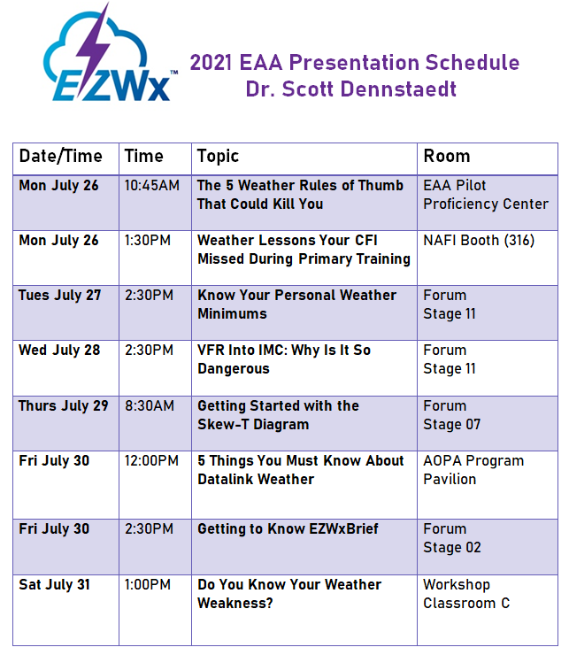
I will have a booth in Hangar C this year at EAA’s AirVenture (#3002, listed under AvWxWorkshops). Stop by and say hello. Also, mark your calendars now. I’ll be offering eight presentations throughout the week for you to attend to learn more about weather. Here’s the schedule… Hope to see you there!
-
- 1
-

-
Turns out that the obstruction to vis (e.g., FG, BR, HZ) placed in an ASOS report is highly dependent on the dewpoint depression as I discuss here.
-
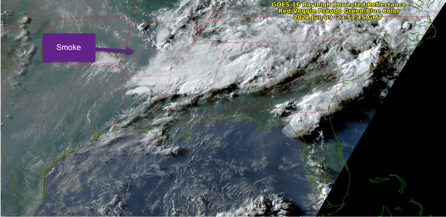
Pretty likely. There's a hell of a lot of smoke across much of the Lower 48 -- and over AR in particular. Increased haziness becomes highlighted later in the day (as the sun-satellite geometry creates more forward scattering from aerosols as you can see in this image as a pale brown color): The period of light winds probably allowed smoke to subside within the boundary layer and reach the surface -- surrounding areas with convection likely had enough wind to ventilate the surface and keep the vis higher during some of the time.

-
So what the hell is going on in Jonesboro, Arkansas? Vis of 10SM ends up dropping off to 1/2SM and then dropping to less than 1/4SM. No significant weather occurring at the airport. KJBR 092219Z AUTO VRB04KT 10SM SCT029 BKN037 29/22 A2994 RMK AO2 KJBR 092207Z AUTO 22005KT 10SM BKN029 OVC035 29/22 A2995 RMK AO2 KJBR 092153Z AUTO 00000KT 10SM SCT029 BKN035 29/23 A2995 RMK AO2 SLP138 KJBR 092130Z AUTO 21003KT 10SM FEW027 29/22 A2996 RMK AO2 T02940222 KJBR 092122Z AUTO 23006KT 10SM BKN027 BKN034 30/22 A2996 RMK AO2 KJBR 092108Z AUTO 25004KT 3SM HZ SCT027 30/22 A2996 RMK AO2 KJBR 092106Z AUTO 26006KT 1/2SM HZ SCT027 30/22 A2996 RMK AO2 KJBR 092053Z AUTO VRB03KT M1/4SM HZ BKN027 30/22 A2996 RMK AO2 SLP143 KJBR 092040Z AUTO 33005KT 4SM HZ BKN023 BKN029 31/23 A2997 RMK AO2 KJBR 092037Z AUTO VRB04KT 3/4SM HZ OVC025 30/22 A2997 RMK AO2 KJBR 092025Z AUTO 29006KT 1/4SM HZ BKN023 OVC029 29/22 A2997 RMK AO2 VIS M1/4V5 KJBR 092018Z AUTO 29007KT 1/2SM HZ BKN023 OVC029 30/23 A2998 RMK AO2 KJBR 091953Z AUTO 33006KT 10SM BKN022 OVC029 29/23 A2998 RMK AO2 SLP150 KJBR 091853Z AUTO 26005KT 10SM BKN021 28/22 A3001 RMK AO2 SLP159 KJBR 091753Z AUTO 24008KT 10SM BKN017 28/23 A3002 RMK AO2 SLP163
-
Join me on June 30th at 8 pm EDT for a free educational webinar that provides Wings credit for those that attend. Register at the link below. This webinar is sponsored by SiriusXM & the Ninety-Nines and features a discussion of preflight weather planning for summertime flying. https://siriusxmcommunications.com/aviationwebinars
-
Mountain Waves over the Appalachian Mountains
Scott Dennstaedt, PhD replied to Bartman's topic in Miscellaneous Aviation Talk
These are called trapped lee waves and are very common over the Appalachians. It has a very classical signature on the Skew-T diagram.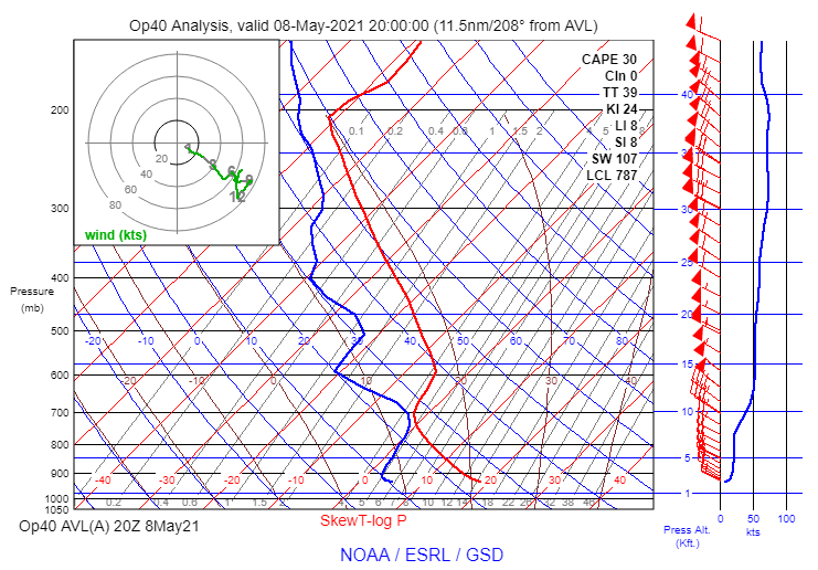
-
Who is at Sun n Fun?
Scott Dennstaedt, PhD replied to Tim Jodice's topic in Miscellaneous Aviation Talk
I am in Hangar C. Will be doing a presentation tomorrow (Friday) at 9 am on Personal Weather Minimums and Saturday at 9 am on the Skew-T in CFAA room #1. Will be giving away two of my books at the end of the presentation. -
Will be doing one last FB Live session today (Sunday) at 3 pm EDT.
-
Video posted on FB for those that could not attend live.
-
Just a reminder that I will be on Facebook Live again tonight (Saturday) at 7:30 pm EDT to go over the weather analysis using EZWxBrief for the SUN 'n FUN event. Will likely discuss the weather on Sunday, Monday and Tuesday. Even if you are not attending the event, there is some educational value of listening in.
-
Reminder…join me tonight on FB Live at 7:30 pm EDT.
-
For those interested, I will be doing a Facebook Live presentation tomorrow (Thursday) at 7:30 pm EDT to go through the weather for Monday/Tuesday next week for the SUN 'n FUN fly-in. It'll likely be about a 20-30 minute presentation and I hope to record it (assuming the Internet gods are shining down on me). I will likely do another one on Friday and Saturday (and possibly Sunday) if there's something pressing to talk about. Even if you are not going to the event, you may learn a few things.
-
No major updates to report at this time. The Southeast U.S. appears to be free of any major weather system at this point on Tuesday afternoon. This doesn't imply there will be no threats for icing, turbulence or even pulse thunderstorm activity in Florida. From the GFS model, it appears there will be a weather system with weak upper level support in the north and central Plains. And a deep upper level trough impacting the Northeast U.S. that will bring down freezing levels to near the surface in that region. I'll likely be up on Facebook Live starting on Thursday of next week to do a more detailed overview of the weather for the region. Stayed tuned for that announcement.
-
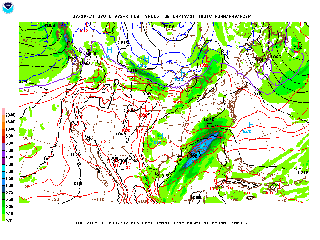
Won't likely start making frequent updates until April 8th or so, but you can see here that since the first forecast, there is a significant change in the forecast. Whereas the GFS was forecasting a nasty event for the Southeast, this forecast is just the opposite with decent weather throughout Florida and Deep South. This will likely change back and forth for the next week or so until it’s about five days out where the forecast will be more certain.

-
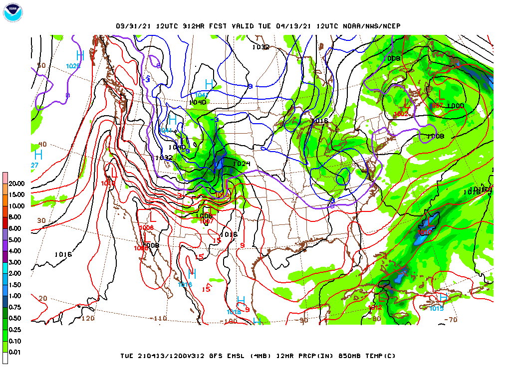
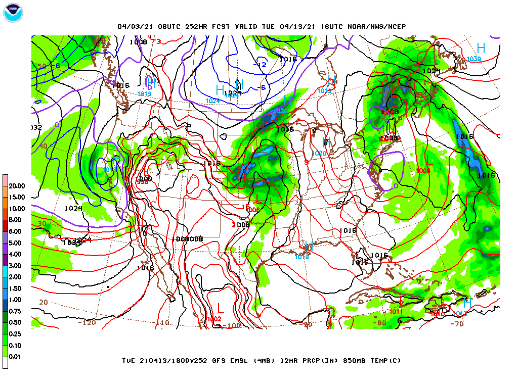
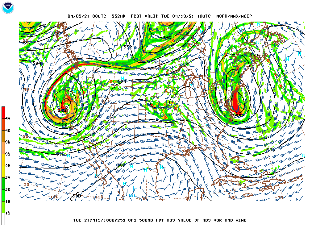
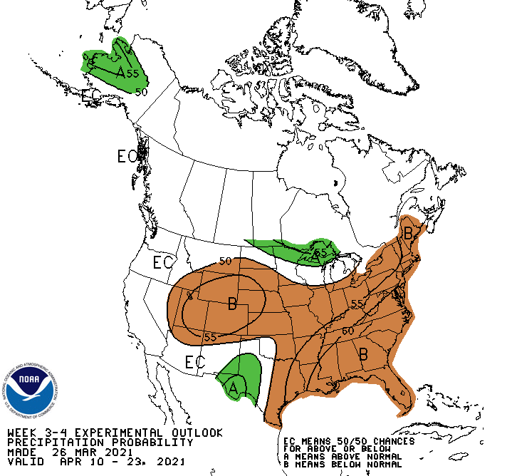
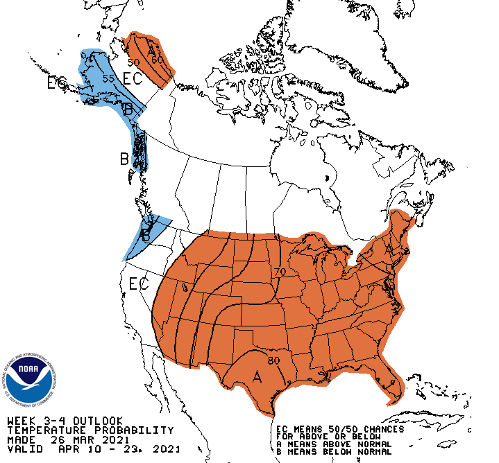
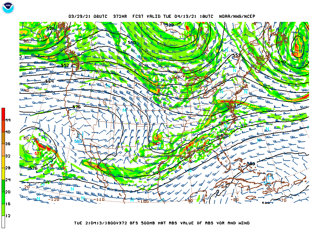
I thought I'd kick off a weather thread for those that are planning to attend SUN 'n FUN 2021 (or anyone who would like to learn a bit more about weather). It's really, really too early to make any distinct decisions one way or another, however, it's always good to assess trends. As I have done for previous events, I will likely take some time and record and post a video or two or three to my YouTube channel to cover a more in depth view of the weather for those who are planning to fly to Lakeland at the start of the event. Meanwhile, about the best you can do at this point in time is understand if the weather is going to be warmer or colder than normal or wetter or dryer than normal. Here is the 3-4 week outlooks from the Climate Prediction Center that show most of the country will be warmer and dryer than normal. "A" means above average and "B" means below average. What does this mean? Above average temperature with below average rainfall implies that we will likely be under a subtropical ridge over much of the eastern 2/3rds of the country during the period from April 10 through April 23. That does not imply that there won't be any weather. We could see some localized areas of pulse thunderstorms throughout the Southeast U.S. during this time. Also, it doesn't prohibit a major weather system from moving through the area. In fact, there is a significant upper level trough expected to move through the Deep South on Tuesday and into Wednesday as can be seen by this 500 mb forecast. This will bring some significant weather to the Southeast U.S. on Tuesday and Wednesday, with rainfall amounts in the 2-3 inch range over a 12 hour period as a frontal system with some upper level support tracks east through the period. Of course, this is very much subject to change given that this is nearly 16 days out. But I often like to post something like this so that on the 12th and 13th we can compare just to show how difficult it is to forecast this far out with any certainty.

-
Are you going to Sun 'n Fun? Part deux
Scott Dennstaedt, PhD replied to 1964-M20E's topic in Miscellaneous Aviation Talk
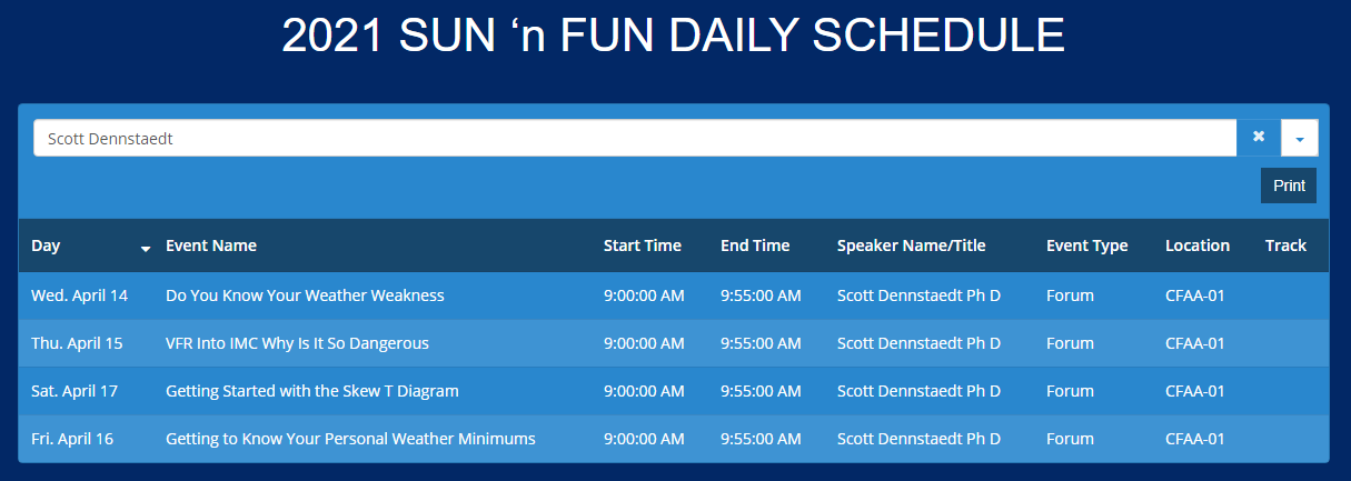
I am scheduled to be there as a vendor with my booth in Hangar C (C-92) listed under Avwxworkshops Inc. Will be doing four presentations at 9 am on Wednesday, Thursday, Friday and Saturday. Note that the SnF forum daily schedule tool doesn't quite order the days correctly. The topics and the days are correct, but the last two should be flipped. I will be giving away a few of my Pilot Weather books at each of the presentations and will also have a daily give-away for my book and 1-yr subscription to my website. So stop by and say hello!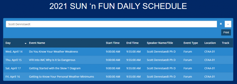
-
Dan, Good feedback. Even though I sell a weather book, this is just the foundation. Important, but there is a need to learn how to integrate all of this guidance so you understand how to characterize that big picture. I have been doing a 1-on-1 online training with pilots over the last 15 years for flights they are looking to take. This makes it real and likely one of the best ways to learn how each piece of guidance contributes to making a good decision. Given that each weather event is unique, it’s really hard to put this kind of training in a book. So seeing it all in action for a flight you may take is something you just can’t get from a book.
-
Wrote up some more details in my blog here.