Scott Dennstaedt, PhD
-
Posts
456 -
Joined
-
Last visited
-
Days Won
3
Content Type
Profiles
Forums
Blogs
Gallery
Downloads
Media Demo
Events
Everything posted by Scott Dennstaedt, PhD
-
 If you have not yet registered, I will be presenting a FREE live webinar on Wednesday, October 20th at 8 pm EDT. The topic of the webinar is Preventing VFR Into IMC: Using Your Personal Weather Minimums. This program is being hosted by EAA and qualifies for FAA Wings credit. Registration is required, and space is limited. To register, visit https://eaa.org/webinars then scroll down on that page to locate the webinar above. You do not have to be an Experimental Aircraft Association (EAA) member to register and attend the live program. If you cannot attend live, this webinar will be recorded, but you must be an active EAA member to view the recorded version. FYI: This is a different webinar from the one I am doing for this group the following night.
 -
John, The details are in my post above.
-
It appears we have enough folks that are interested and willing to attend. I will attempt to record this webinar and make it freely available after the fact. There will be a Q&A session at the end of the presentation...so if you attend live, you will have the opportunity to ask a question. Therefore, I can confirm that Thursday, October 21st at 8 p.m. EDT (0000Z, October 22nd) will be the date and time of this webinar sponsored by EZWxBrief. The webinar should last 50 minutes with a 10 minute Q&A. Here is the link to the Zoom meeting: Topic: 2021 Mooney Summit presentation on weather sponsored by EZWxBrief Time: Oct 21, 2021 08:00 PM Eastern Daylight Time (US and Canada) Join Zoom Meeting https://uncc.zoom.us/j/98368886764?pwd=Qk9nRHdoeG4wUVhVUDJHU1ptejhQUT09 Meeting ID: 983 6888 6764 Passcode: 946402 Keep an eye out in this thread for any changes to the schedule.
-
I can't promise it will be recorded, but that is the goal. If all the planets line up and the technology works, I may be able to make it available to the group a week or so after the presentation (depending on my current workload).
-
Yes, there are many...too many to fit into a one hour webinar. Maybe a full day webinar, but not an hour. Actually, I will be discussing two specific ones that tend to stand out based on my experience teaching weather to pilots for the last 25 years.
-
The title of the presentation is, "What is your weather weakness?"
-
I believe the content should be applicable (mostly) for pilots outside of the U.S.
-
I was looking forward to this year's Mooney Summit. Really bummed it was postponed. Nevertheless, I still wanted to hold the presentation I had planned to do, but virtually. I don't have a solid date and time yet, but thinking Thursday, October 21st at 8 p.m. EDT...will post the official time here once I can solidify my schedule. I'll be more than happy to do this assuming I can get a good number to attend (say 30 or more). If there's very little interest, I won't bother. So, please add a "Thanks" or "Like" to this post if you are interested so I can get a feeling for the number of you that might be willing to attend.
- 26 replies
-
- 32
-

-

-
NOAA43 Flying in the hurricane
Scott Dennstaedt, PhD replied to N201MKTurbo's topic in Miscellaneous Aviation Talk
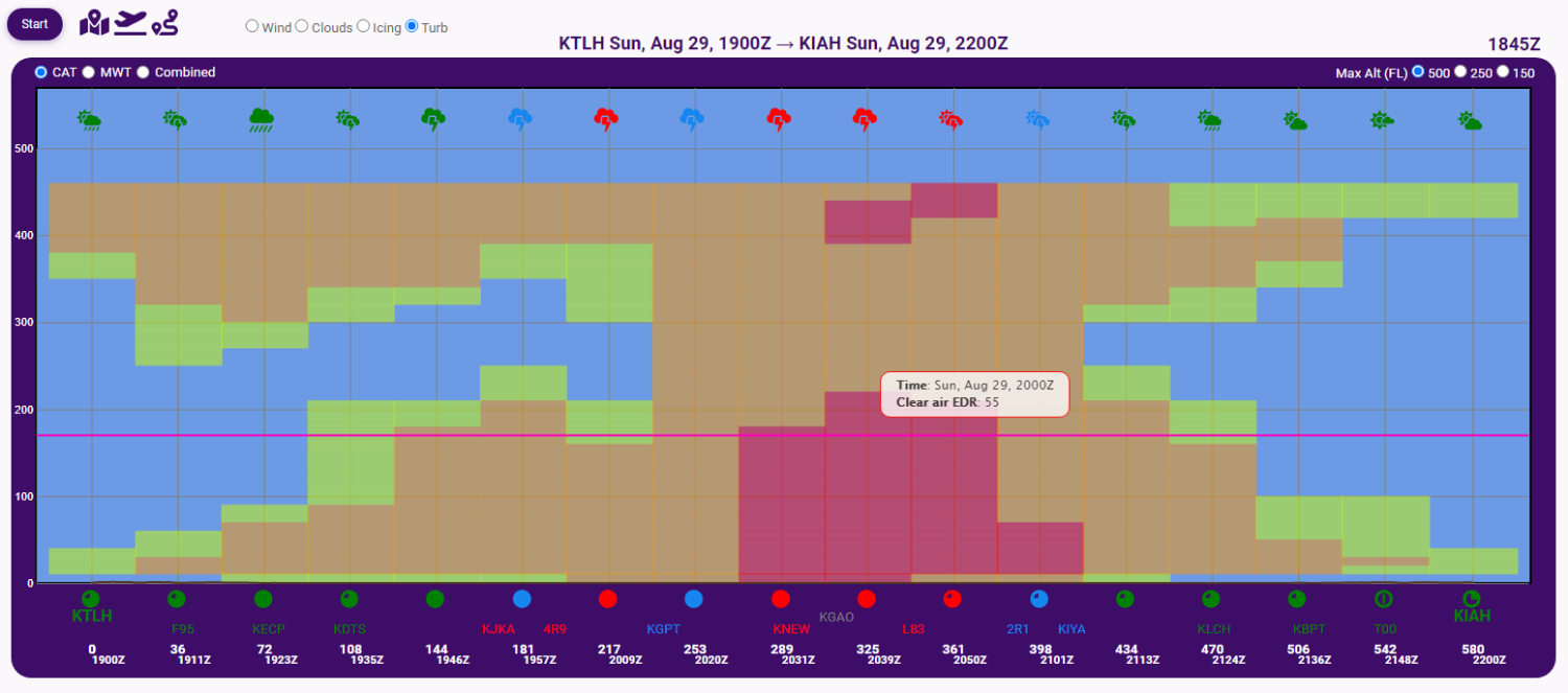
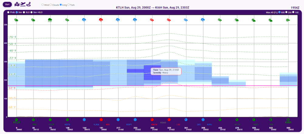
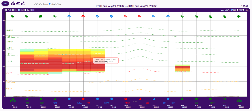
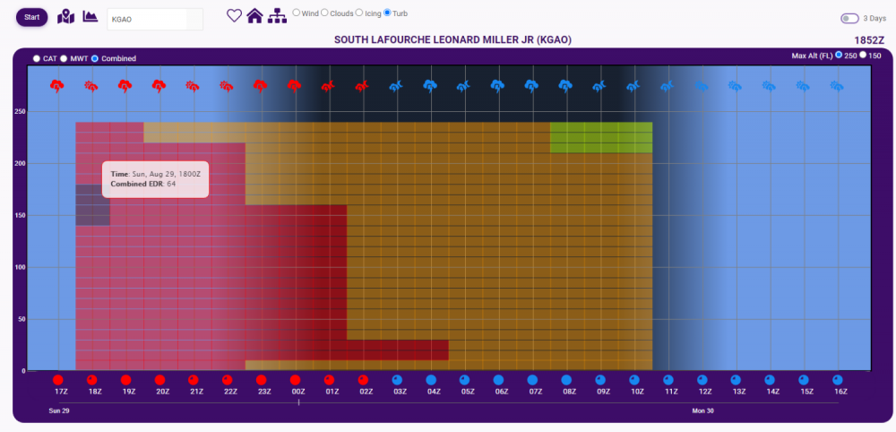
Yes, in a light aircraft this is what you would experience flying through this area today. EZWxBrief shows EDR values of 55 which is approaching extreme turbulence. One of the reasons these aircraft fly at 10K is to avoid getting into any significant airframe ice. These storms tend to dish out some heavy icing and SLD. It's pretty cool that you can see the "hump" in the isotherms with higher temps right in the eye of the storm. And here's some extreme turbulence showing up as the weather system passed right by KGAO.
-
Minnesota Crash
Scott Dennstaedt, PhD replied to Davidv's topic in Mooney Safety & Accident Discussion
The NTSB preliminary report has been posted for this accident. Read it here. Not a lot of new information in the report, but some info on the debris field and examination of the wreckage that might be of interest. -
The AOPA Aviator Showcases are being held in Manassas, VA and Fort Worth, TX on August 27th and October 1st, respectively. I believe attendee registration is required (no walk ups). If you are attending one of these, I’ll be doing a presentation at both events in the morning. Stop by and say hello.
-
Minnesota Crash
Scott Dennstaedt, PhD replied to Davidv's topic in Mooney Safety & Accident Discussion
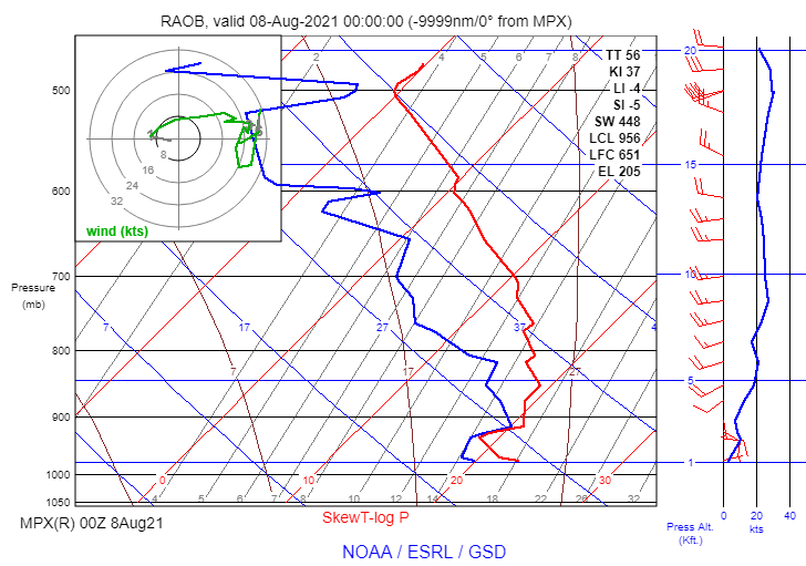
This depends on the data you are plotting (e.g., RAOB vs Model), temperature of the environment (cold vs warm stratus) and type of cloud type (cumuliform vs stratiform). What I posted for this accident was a RAOB, so it will very accurately depict the bases and the tops of the clouds since the sensor measures 100% RH as it ascends through the cloud. It is quite common, however, in a stratocumulus cloud deck for there to be fairly moist conditions above the deck, but still have a very highly capped scenario where the clouds do not have vertical growth. Here's an example. Notice the solid deck below and the rather dispersed clouds just above. In this case, the air above the stratocu deck was likely very moist nearing saturation. Nevertheless, it's pretty clear in the ROAB in my blog post that the tops of the primary cloud deck were defined reasonably well around 2,800 feet MSL. Could there have been a very dispersed area above? Possibly, but not very likely. When looking at model forecasts on the Skew-T (called a forecast sounding), you can have very similar profiles for stratiform clouds, but cumuliform clouds are a different beast altogether. The Skew-T only predicts the environment for which the can grow, not the clouds themselves. So you can have a broken area of fair weather cumulus several thousand feet deep or even towering cumulus and they won't likely show up on a forecast sounding like you might think. That's because they are created through ascending air. For that, you need to lift a parcel of air to determine their extent.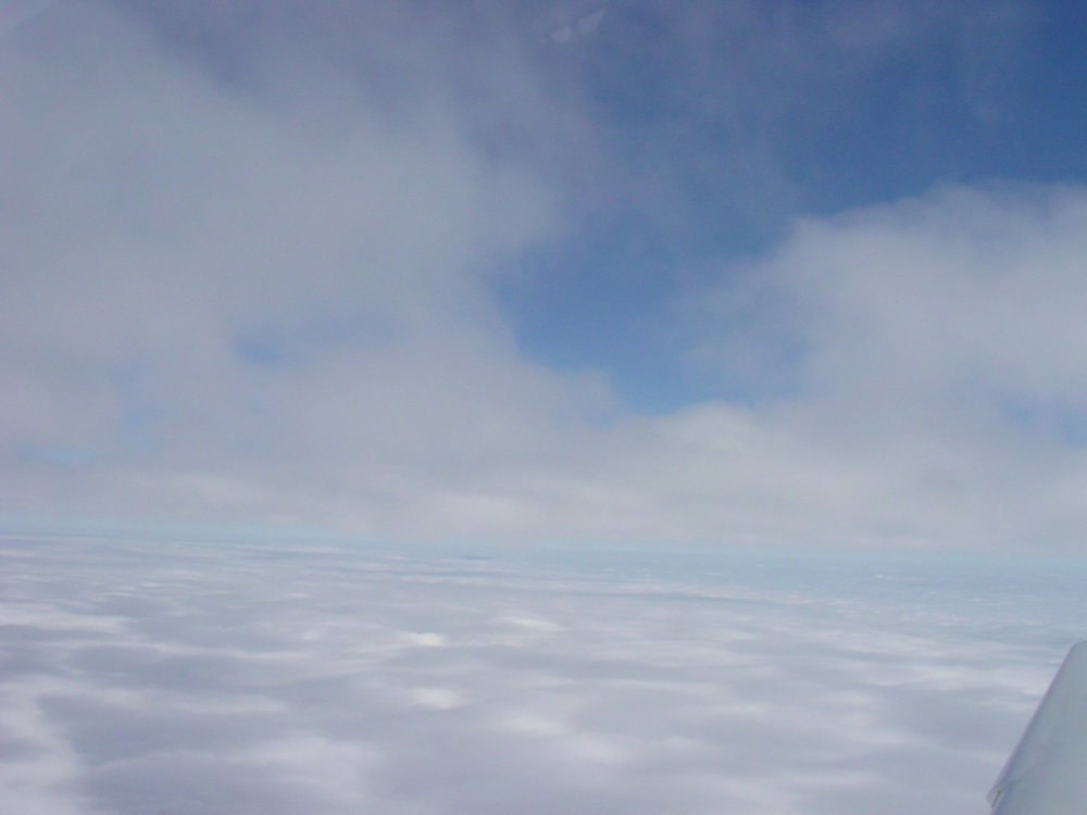
-
Minnesota Crash
Scott Dennstaedt, PhD replied to Davidv's topic in Mooney Safety & Accident Discussion
Yes, statocu will have a lumpy appearance (quilt-like) on top. Essentially if the air below has enough momentum (it was pretty unstable below the cloud base), it might overshoot (momentum) a little bit which creates that lumpy look (think about a pot of boiling water). So it's possible that you may see some areas a few hundred feet deeper. Pretty negligible though. -
Minnesota Crash
Scott Dennstaedt, PhD replied to Davidv's topic in Mooney Safety & Accident Discussion
I can guarantee you that in the NTSB final report, the investigators will use this RAOB when defining the weather at the time of the accident. Heck, they sometimes will use RAOBs that are 100 miles away and many hours prior (or after). So this will be the investigator's dream come true with respect to getting accurate data close to the time of the accident. But it's still funny to read on a few of those "other" aviation boards pilots trying to suggest that this was due to some kind of microburst event or that the layer of clouds was several thousand feet deep. Ugh! -
Minnesota Crash
Scott Dennstaedt, PhD replied to Davidv's topic in Mooney Safety & Accident Discussion
Also an emergency checklist may also help with some of that overload in some circumstances...as well as practicing emergency procedures. Over the last 25 years of flying, I've had my share of weirdness happen in an airplane in IMC and I'd have to say, the checklist was invaluable in all those situations. -
Minnesota Crash
Scott Dennstaedt, PhD replied to Davidv's topic in Mooney Safety & Accident Discussion
Agreed. Even with a shallow descent rate it should have taken less than 30 seconds to descend through a 600 ft layer of relatively smooth air without some kind of extenuating circumstances (e.g. control surface failure, incapacitation, etc.). -
Minnesota Crash
Scott Dennstaedt, PhD replied to Davidv's topic in Mooney Safety & Accident Discussion
I've been reading on some other forums that there are some pilots that think this accident is related to convective turbulence or a microburst. Here's a more protracted discussion in my blog that documents the weather at the time of the accident that demonstrates otherwise. https://www.avwxtraining.com/post/weather-analysis-for-recent-mooney-accident-near-minneapolis Enjoy. -
Minnesota Crash
Scott Dennstaedt, PhD replied to Davidv's topic in Mooney Safety & Accident Discussion
John, I assumed the accident was 5:40 pm CDT based on the Flightaware track? At that time the accident area was dominated by a thin stratocumulus deck. The only cell was over 30 miles to the southeast. This cell was rapidly dissipating and moving ENE well south of the MSP area. The IR image I posted earlier also shows just a stratocumulus deck in the immediate area of the accident. There was no deep, moist convection within 30 miles. I also checked the Level II NEXRAD to see if there were any outflow boundaries passing through the approach corridor to FCM. Didn't see any. The only thing I see in the NEXRAD shows a stabilizing atmosphere setting in with time.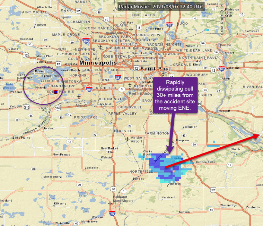
-
Minnesota Crash
Scott Dennstaedt, PhD replied to Davidv's topic in Mooney Safety & Accident Discussion
Yes, there was a RAOB taken pretty close to the time and location of the site of the crash. This shows the bases of this stratocumulus deck were ~1200 ft AGL and tops were ~2700 ft MSL; so the clouds were less 1,000 feet deep. The sky was overcast which is also seen on the IR satellite imagery. So an instrument approach would be necessary given the weather at FCM. KFCM 072353Z 09007KT 9SM OVC012 22/19 A2977 RMK AO2 SLP077 T02220194 KFCM 072253Z 06007KT 10SM OVC013 23/19 A2976 RMK AO2 SLP075 T02280194 KFCM 072153Z 08010KT 9SM OVC011 22/20 A2977 RMK AO2 SLP078 T02220200 KFCM 072100Z 08009G17KT 10SM OVC011 22/19 A2978 RMK AO2 T02220194
-
Minnesota Crash
Scott Dennstaedt, PhD replied to Davidv's topic in Mooney Safety & Accident Discussion
Brad, Not that I can see. There was a pretty nasty MCS that was to the ESE of the area as you can see on the IR satellite, but the tops in the area at the time of the accident were pretty low so the likelihood of any deep, moist convection was near zero. Tops in the area were around 3,000 ft MSL based on this RAOB shown below that was launched about 15 minutes prior to the accident and only about 5 miles away. That's about as good as you are going to get for weather info. KFCM 072353Z 09007KT 9SM OVC012 22/19 A2977 RMK AO2 SLP077 T02220194 KFCM 072253Z 06007KT 10SM OVC013 23/19 A2976 RMK AO2 SLP075 T02280194 KFCM 072153Z 08010KT 9SM OVC011 22/20 A2977 RMK AO2 SLP078 T02220200 KFCM 072100Z 08009G17KT 10SM OVC011 22/19 A2978 RMK AO2 T02220194 There was a wind shift right at the tops which is very common with stratocumulus decks that are largely created because of low-level instability and moisture (ground was fairly moist). The air tends to dry out where the inversion stops because the winds switch to a more southwesterly (dry) flow.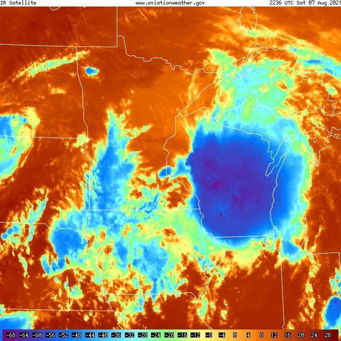
-
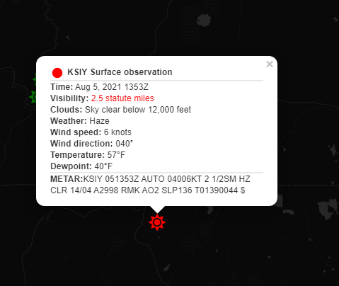
An automated system cannot report smoke (FU). It can be augmented by a human observer, however. Typically with smoke an automated observation will be sensed as lower visibility and typically given a haze (HZ) obstruction to vis. Unless there's a distinct fire nearby, you will usually get a clear below 12,000 indication for ceiling. Here's an example from EZWxBrief. The sky is reported as clear below 12,000 feet and the visibility is in the IFR category with 2.5 miles vis and haze. There's no way to know if the reduced vis was due to smoke without an augmented report from a trained observer.
-
We are way too early to know that at this point. Check back with my Facebook Live broadcast on Thursday or Friday possibly. About the only thing we can say with any reasonable certainty is that the temperatures are going to be slightly warmer than normal with near normal (or very slightly above) for precipitation.
-
Greg, You are welcome. Monday and Tuesday will be very broad outlooks and should begin to set the stage for the rest of the week.
-
Good timing here Jim... I just published my latest video with some tips for summertime preflight planning using my progressive web app, EZWxBrief. Enjoy.
-
Twins are No Safer Than Singles
Scott Dennstaedt, PhD replied to KLRDMD's topic in Miscellaneous Aviation Talk
The real value is looking at multiple sources on the same subject across differing journals. I read over 250 accident studies in dozens of journals over the last 3.5 years. I know many of these researchers personally (have met them, know their background, exchanged emails, spoke on the phone, etc.). Their research differs in some cases, but that's just part of the natural process to understand the topic of interest. But if someone doesn't like the results of a particular study, my response to them is, "go do the study yourself."