Scott Dennstaedt, PhD
-
Posts
457 -
Joined
-
Last visited
-
Days Won
3
Content Type
Profiles
Forums
Blogs
Gallery
Downloads
Events
Store
Everything posted by Scott Dennstaedt, PhD
-
 Sure. The point is that with the same EDR values the different airframes the passengers and crew are likely to experience turbulence in a different way. So, while it won't be easy to drink your coffee without spilling some in seat 14B with an EDR value of 38 in the B737 (moderate), most of the coffee would likely end up on you in the M20R (severe).
 -
Understood, but an EDR value of 38 is considered moderate for an aircraft like a B737, but that is in the severe category for a M20R. No injuries in the B737, possible injuries in a M20R.
-
There has been some shuffling of aircraft, but in the end we still have about 200 aircraft that we have access to for this data. These are mostly from SWA and DAL. However, there are many more aircraft (at least another 200) that use the in situ EDR onboard algorithm, but we do not have access to that data. Industry is trying to rectify this (after all, shouldn't a severe report be available to everyone?), and the probable avenue is through IATA, who is developing a world wide dataset of EDR data. Of course, most of this data is in the upper flight levels.
-
An in situ turbulence reporting algorithm has been implemented on some U.S. airliner such as United and Delta. There's currently about 200 aircraft in the fleet the last time I checked. The algorithm estimates atmospheric turbulence intensity as inferred from the cube root of the energy or what is called eddy dissipation rate (EDR) that is largely based on estimated vertical wind velocity or aircraft vertical acceleration. And if you really want to see interesting technology that could be implemented on any aircraft you can read up about GPS Occultation.
-
Airspace variance at cruise and descent.
Scott Dennstaedt, PhD replied to Mac80's topic in Modern Mooney Discussion
Not sure what might be going on without doing a lot of digging, but it does smell a lot like gravity waves. -
Dan, Yes, I have a notification turned on from my website whenever the EDR values jump above 60 was surprised to see a couple of locations where they were 70. Usually you don't see this unless it is associated with a landfalling hurricane.
-
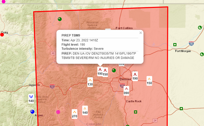
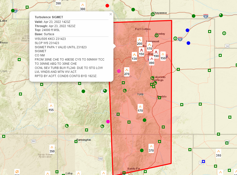
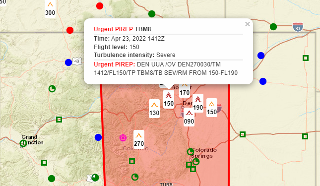
Agreed. But to be fair, these non-convective SIGMETs are rarely issued until pilots begin to report turbulence. Even tho they are technically a forecast, they live and die by PIREPs. Most of the PIREPs of severe turbulence were made prior to the issuance of the non-convective SIGMET at 1423Z. Here's another one of a TBM9 reporting severe turbulence at 1410Z.
-
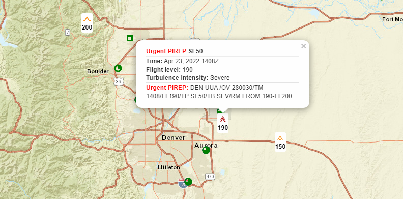
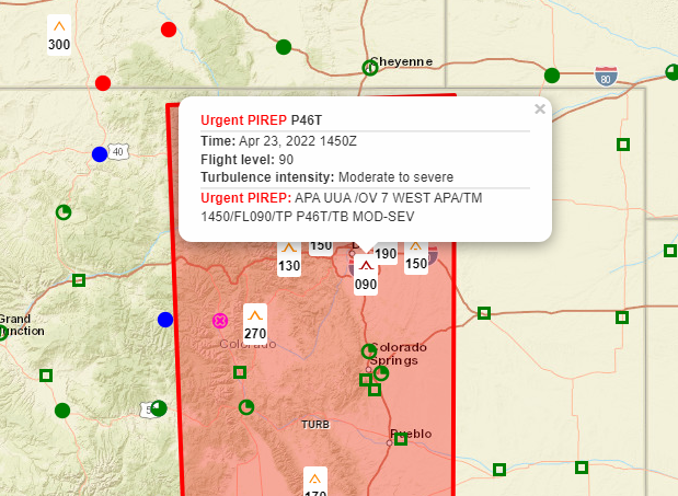
Right on time, there have been numerous aircraft this morning reporting moderate and severe reports of turbulence in this area. And, the AWC issued this SIGMET… Notice the altitude reported by this Vision Jet... TBM as well... And a PA46...
-
I'm seeing even sporadic areas with EDR values near 70 in this region. Most of that is near the surface further west into the mountains.
-
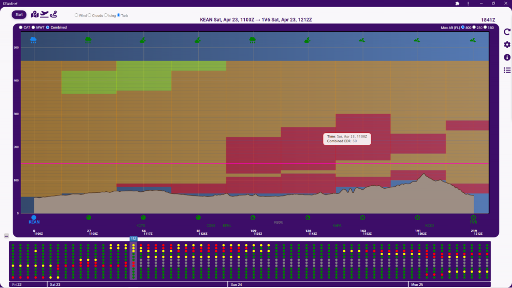
If you are planning to fly anywhere near Denver early tomorrow morning it’s very likely to see some low- and mid-level severe turbulence along the Front Range. You can see that the EDR values are up near 60 (EDR * 100) just to the west of Denver as shown below on the EZWxBrief route profile. Extreme turbulence starts at 64. This is all in response to an intense negatively tilted upper-level trough moving through the central Rockies later tonight into early tomorrow morning. This is even easier to see on the Skew-T Diagram. Notice the wind profile especially at 20,000 feet.

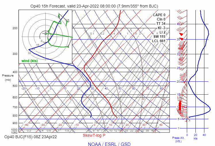
-
There are a couple definitions of argue - 1) Yes, it is important to argue based on the definition to "give reasons or cite evidence in support of an idea, action, or theory, typically with the aim of persuading others to share one's view." 2) Not good to argue to "exchange or express diverging or opposite views, typically in a heated or angry way." Disagreement or opposing views is normal and it is often a great way for people to learn about a topic if done in a civilized way (see definition #1). It has certainly taught me a lot about what I should and should not be teaching pilots when it comes to weather. Most pilots have a very skewed view of the discipline and the recipe for mountain waves is one of them. If you haven't read it, Think Again by Adam Grant is an excellent book on this subject. Hope that make sense?
-
Unless you want to learn something... - I've been doing this for 42 years, so the book is long overdue.
-
Yes, as I mentioned, wind speed and direction are important, but they are just one ingredient in the gravity wave recipe.
-
Actually that is not the recipe for mountain waves. Certainly wind speed and direction are important, but stability to create the negative buoyancy is part of the recipe.
-
100% not thermals. The lapse rate in the lower part of the atmosphere at 8 a.m. was very stable...notice the fog layer as well. If this were later in the afternoon and he was at the top of the boundary layer, possibly. The Skew-T is often used to determine the potential for mountain wave activity as I will describe in my next eBook. For this case, it was not a "classic" vertically-propagating lee wave signature.
-
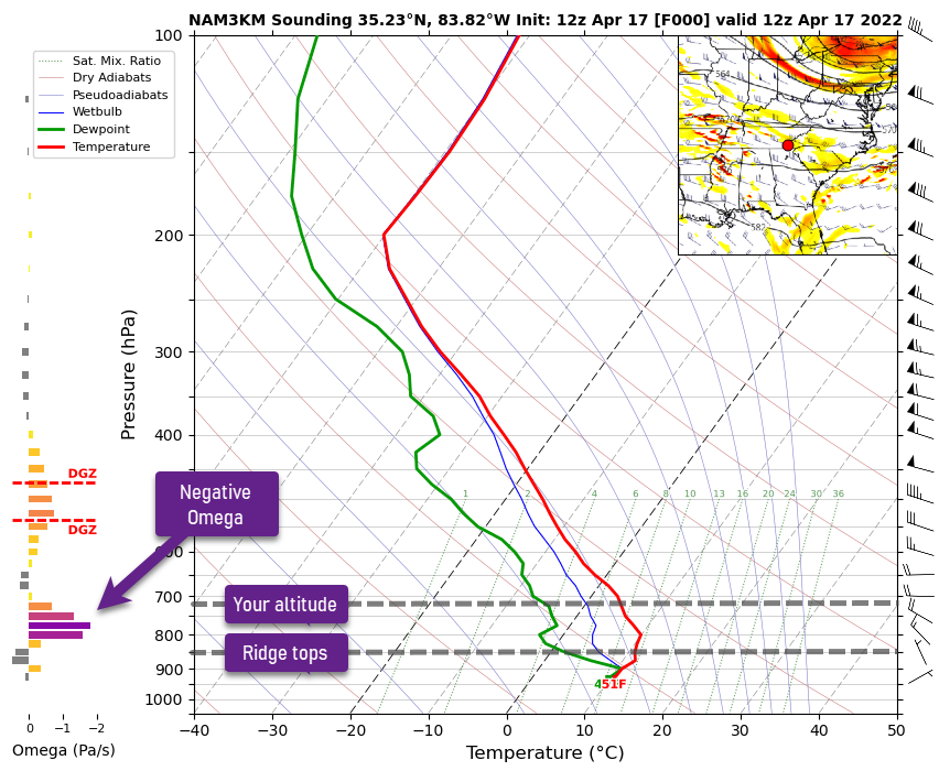
Jim, Likely some kind of wave activity given the upwash you experienced. That's really the only plausible explanation given your position over the mountains. There was primarily zonal flow over the region which gives you the proper wind direction and there was a good stable layer at the surface to help induce some gravity waves. The unstable air above will certainly help propagate those waves upward to your altitude. But what stands out the most is the negative omega from about the ridge tops up to your altitude. This describes air that is moving away from the earth. It's not very high by any stretch of the imagination. Doesn't really tell you specifically there is mountain wave activity in the region, but it certainly doesn't eliminate the possibility. I'm guessing that if you were 1000 feet higher you may have not experienced any upwash and if you were 1000 to 2000 feet lower you might have experienced a bit stronger upwash. I'll be discussing some of this in my new book, The Skew-T log (p) and Me that should be available in eBook format before AirVenture. Hope this helps.
-
It's interesting that you say this. When I set out to do these daily briefings they were not meant to be "training" videos, but informational...that is, give you some basic weather guidance so the viewer was better prepared to make decisions about a proposed flight. I had never intended these to have any intrinsic training value. Most of the comments that I've gotten over the last few weeks from pilots tuning in every day is that the real value in these videos isn't the weather information I'm providing, but the training that comes packaged with them. As you say, the repetitive nature of these daily briefings is driving home a significant educational component. This was a pleasant surprise. Thanks for tuning in!
-
Sun n Fun 2022 Who's going?
Scott Dennstaedt, PhD replied to 1964-M20E's topic in Miscellaneous Aviation Talk
I'll be there and doing four presentations that are posted on the SUN 'n FUN daily schedule. Feel free to stop by the SiriusXM tent. I will be hanging out there from time to time from Wednesday to Friday to answer any questions you may have. I will also be at the Society of Aviation and Flight Educators (SAFE) booth in Hangar A on Wednesday 3 - 4 pm, Thursday 3 - 4 pm and Friday 9 - 10 am. Stop by and say hello!
-
Just a quick reminder that the SUN 'n FUN Daily Weather Roundup live stream starts this Wednesday at 3 pm EDT.
-
For those interested, my Daily Weather Roundup for SUN 'n FUN starts next week on Wednesday, March 30th. Join me live on the EZWxBrief YouTube channel beginning at 3 pm eastern time. If you are flying you may want to watch each day to gain a better appreciation of the weather challenges that you may face flying to the event. Even if you are not flying to SUN 'n FUN or even attending the event, it may be an educational opportunity to learn how to interpret medium- to long-range forecasts. Each daily broadcast will be 20 to 30 minutes long and that includes a broadcast on Saturday and Sunday at the same time. The last live broadcast will be on Monday, April 4th. They will be recorded and available on the same YouTube channel shortly after the broadcast ends. At the moment, the GFS model is predicting a potent upper-level trough moving out of the southern Rockies on Wednesday morning, but a ridge dominates most of the eastern U.S. during the early part of the week providing for nice weather in that area. This is more than 10 days out, so there's a lot of uncertainty here in this forecast.
-
Some of you may remember the A.M. Weather program that was broadcast every morning from Owings Mills, Maryland through Maryland Public Television. Hopefully my rendition won’t tarnish its legacy.
-
Nice to hear. I have been offering that service for about 15 years. I do 1-on-1 online training...not acting as your briefer or providing a dispatch service, but teaching you how to properly do a route-based briefing, but you will walk away with an outstanding view of what to expect on your flight.
-
It's a work in progress that will evolve over time.
-
For those that may be interested, this week I started broadcasting a daily weather brief every morning at 7 a.m. eastern time on YouTube Live. The goal is to provide general aviation pilots with a brief weather overview of today's weather impacts across the conterminous U.S. and southern Canada. It is being recorded and will be available on the EZWxBrief YouTube channel shortly after the live broadcast. Click here to view today's Daily EZ Weather Brief. Whether you are flying today or not, I hope you can tune in each day to watch. Please note that this video is being freely offered for educational and entertainment purposes only and should not substitute as a formal weather briefing as required by 14 CFR 91.103.
-
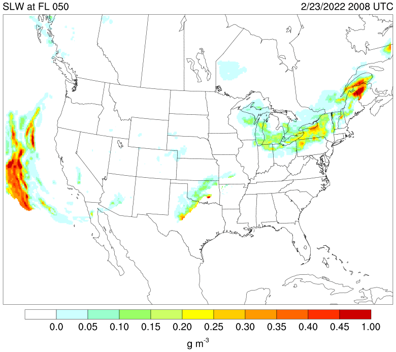
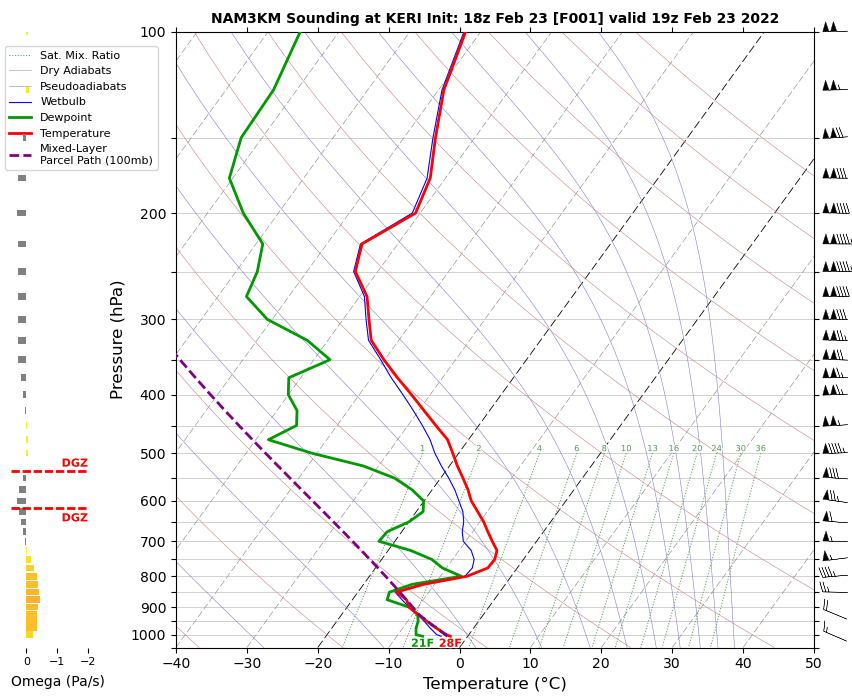
Norm, Appears you descended through a stratocu deck into Erie. These clouds tend to have a high liquid water content near the tops especially in the warmer subfreezing temperature regime. With snow on the ground in Erie, it's even more likely you'll run into larger drop sizes. KERI 232024Z AUTO 31011G17KT 1 3/4SM -SN SCT013 BKN018 OVC024 M03/M07 A3036 RMK AO2 SNB1958 P0000 T10331067 KERI 231951Z 32012G16KT 10SM BKN017 OVC024 M02/M07 A3034 RMK AO2 SNB26E37 SLP284 P0000 T10221067 KERI 231851Z 30013KT 10SM OVC015 M02/M07 A3033 RMK AO2 SNE32 SLP278 P0000 T10221067 The NAM forecast valid at 19Z shows that fairly warm cloud tops were likely around 6,000 ft MSL. The clouds tended to deepen a bit to maybe 7,000 ft by 20Z. In this area it's not unusual sometimes to see high liquid water content right at the top of that inversion (~5,000 ft) even if snow is reaching the surface. With deeper systems (> 12,000 feet) from lake effect snow, it's not unusual to see even drizzle-sized drops at the tops. In fact, there was a fairly high area of supercooled liquid water contents at 5,000 feet along the last part of your route. This is about 0.2 to 0.25 g/m^3 which is pretty high.
.png.547bfb31158ce9851815dbb1b04fa68c.png)