

Scott Dennstaedt, PhD
-
Posts
456 -
Joined
-
Last visited
-
Days Won
3
Content Type
Profiles
Forums
Blogs
Gallery
Downloads
Events
Store
Everything posted by Scott Dennstaedt, PhD
-

Faith in ADSB weather
Scott Dennstaedt, PhD replied to Tim Jodice's topic in Mooney Safety & Accident Discussion
NEXRAD are WSR-88Ds now. You were referring to earlier technology. Night and day. -
Faith in ADSB weather
Scott Dennstaedt, PhD replied to Tim Jodice's topic in Mooney Safety & Accident Discussion
Not exactly. The radar operator at the NWS WFOs will set the radar using one of many scanning strategies...called volume coverage patterns (VCPs). The VCP they use is based largely on the weather they are expecting. Light snow or drizzle might cause them to set the radar to one of the slower clear air mode VCPs. Severe storms will likely trigger them to place the radar in one of the faster precipitation mode VCPs. And with dual-pol and new strategies such as SAILS, mesoSAILS and AVSET, they can get a much better (faster) view of the weather in the area. The radar is never "left" unattended. Even if so, the radar is always doing multiple elevation scans and is never left to scan on a single elevation angle. Here's the RPG screen for the Columbia, SC WFO. It sits right there next to the forecasters where they can monitor its status 24/7.
-
Faith in ADSB weather
Scott Dennstaedt, PhD replied to Tim Jodice's topic in Mooney Safety & Accident Discussion
This is a lot more common than you'd think. In fact, Matt Guthmiller reached out to me to ask me about a similar experience a couple years ago. So I did some research and put together this video. -
Faith in ADSB weather
Scott Dennstaedt, PhD replied to Tim Jodice's topic in Mooney Safety & Accident Discussion
I do agree that you need to be making decisions about your course through/around areas of convection 30 minutes or more ahead of time. Here's what I teach my students. If you are making course changes of more than 30 degrees you are too close to the weather and are likely making decisions too late. I use a 20 degree rule myself. Once I deviate from that more than once, I'm looking for an alternate airport to land and wait it out. I am not a fan of the 15-20 minute latency edict put out by the NTSB. I think that's just as bad as telling pilots it's real time. If the depiction is that old, it's likely due to some missed updates. When the system is working fine, you are looking at 5-8 minutes old from the picture out the window when it is refreshed. Then, depending on the service, you get to stare at that image for 2 to 3 minutes until the next update. So, you are looking at the worst case (barring any missed updates) of a depiction that is 7-10 minutes old. Now that the updates are every two minutes (2.5 min for SiriusXM), it's rare to see a very old mosaic. -
Faith in ADSB weather
Scott Dennstaedt, PhD replied to Tim Jodice's topic in Mooney Safety & Accident Discussion
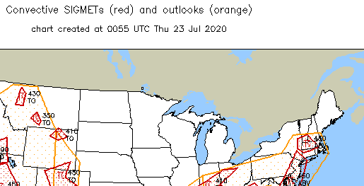
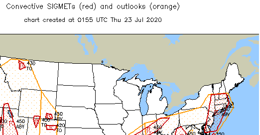
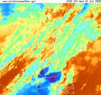
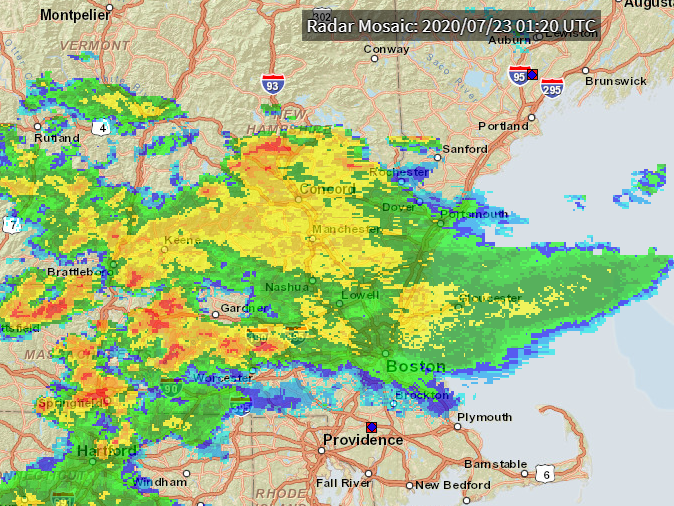
Sorry I'm a bit late to the game...lots going in these days and don't get much of a chance to participate. There's certainly a lot to unpack in this thread and I won't specifically respond to every post, but let's first understand that every weather product or service has its limitations. Every distribution system has it's limitations. Take some time to learn those. First, the preflight portion of a flight is critical to understanding what you see or don't see on your in-cockpit devices. Surprises should be rare. Second, I rarely ever zoom in on an area with a radar mosaic. I have my display zoomed out such that I can understand the organization of the weather and how it matches with my preflight analysis. This helps to understand the trends of the intensity and development or dissipation. Turns out in this situation, that is the key. Third, the FIS-B radar depiction is a composite reflectivity mosaic that recently was switched to using MRMS which I discussed in my blog over a year ago. The regional mosaic data is broadcast and updated every two minutes. This likely the most superior and fresh radar mosaic available today in the cockpit. Even so, it does have real limitations and should always be used as a gross vectoring aid and never used tactically to maneuver through weather. For Tim's original post, there's no way for me to specifically comment on the actual issue you faced. I don't comment on anything associated with FF anyway, and I wasn't in the cockpit and don't really have specific explanation on what you were seeing. However, using the date/time of the flight, it's pretty easy to see what was going on. There was a convective SIGMET issued to the west of the route at 2355Z (7:55 pm). By 0055Z (8:55 pm) or shortly after departure, the convective SIGMET was still to the west of your route. These areas of thunderstorms had tops above FL450. By 0155Z (9:55 pm), the convective SIGMET was expanded to connect to the convective SIGMET to the south and the eastern edge covered the route. Most of the significant convection at this point was to the south. This matches well with the IR satellite image. Note the deep blue/purple tops marking the convective area outlined by the two earlier convective SIGMETs above. These are cold cloud tops indicative of deep, moist convection. With time, these cells began to dissipate creating what is called a convective debris shield which is often characterized with light to moderate stratiform-type rain sometimes with occasional intra-cloud lightning (FIS-B lightning doesn't show intra-cloud lightning, but SiriusXM does). So the dBZ levels can be in the 40-45 range and may often look pretty ominous, but the cellular structure wasn't present. You can see the cloud tops began to warm as this transition occurred (more lighter blue and no purple). Here's the radar mosaic (not the MRMS version), but it clearly shows some fairly moderate returns from this stratiform-type rain falling throughout the destination airport. But the cellular structure is gone. The moral of the story is to understand the limitations of the devices you are using and know what colors represent what level of dBZ (reflectivity). Those colors you see are very dependent on the vendor providing the service and they can be different. Each vendor chooses how to present this depiction (color to dBZ). Hope this helps.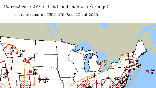


-
Can't trust those NWS employees...caught destroying property!
-
As they say, as long as the aircraft is reusable, it was a good landing. That's always been my goal.
-
Happy to hear that Nick. That's my goal...not to teach you to be a meteorologist, but hopefully to take you to the next level and have it finally "click" as you start putting all of this together.
-
Still seats available for the FREE webinar to be held on April 21st. Reserve your seat today. April 21, 2020 (9:00-10:00 pm EDT)https://www.signupgenius.com/go/20f0d4ba4ab2aa2fd0-summer1
-
GoToMeeting limitations.
-
The April 2nd webinar is full, but plenty of seats left for the April 21st webinar.
-
If you are interested, bored or otherwise need a distraction, I will be doing a free 30-45 minute webinar on April 2 and 21 to knock off the wintertime rust and start to think about our summertime flying hazards. If you attended or bought the recording to my In-Flight Hazard Avoidance Strategies webinar I did last year, you probably won't want to attend this one...it'll be a shorter version/summary of that webinar. There are limited seats available...and please only register for one of the two dates below. They will present the same material. April 2, 2020 (9:00-10:00 pm EDT) https://www.signupgenius.com/go/20f0d4ba4ab2aa2fd0-summer April 21, 2020 (9:00-10:00 pm EDT) https://www.signupgenius.com/go/20f0d4ba4ab2aa2fd0-summer1 An email invite on how to join the webinar will be sent on the day before the webinar. Fly safe and stay healthy!
-
Sun n Fun in the time of Coronavirus
Scott Dennstaedt, PhD replied to TGreen's topic in Miscellaneous Aviation Talk
The CDC just recommended that “for the next 8 weeks, organizers cancel or postpone in-person events that consist of 50 people or more throughout the U.S.” Unless SnF wants to go against this recommendation, they will need to cancel or postpone again. -
Sun n Fun in the time of Coronavirus
Scott Dennstaedt, PhD replied to TGreen's topic in Miscellaneous Aviation Talk
Interesting to see that @sunnfunflyin blocked a Twitter follower because they had suggested "Be smart and cancel the event."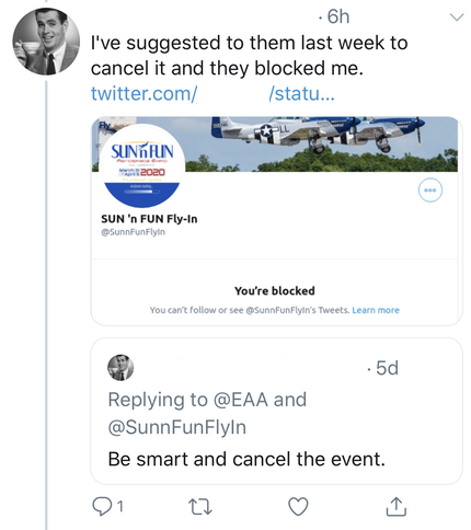
-
The other end of the spectrum is that nobody reacts at all and uses the "it'll not happen to me" or "attend at your own risk" that ends in a horrible outcome with the healthcare system overwhelmed, hundreds of thousands (if not millions dead) and eventually the financial market takes an even greater tumble with entire companies wiped out. Don't confuse preparation with panic. People are not really in panic mode...I don't see people jumping off of bridges yet.
-
Just got off the phone with someone who lives in the "war zone" in Italy and I won't describe what he said to me (first hand, not media) since it is really horrific and just honestly too disturbing to write. I can guarantee you that what I heard was 100X worse that I ever thought. The media isn't covering these details...fortunately. We really don't have a clue and every measure taken is a small glimmer of hope it won't be even a fraction as bad as what has been occurring elsewhere in the world.
-
Sun n Fun in the time of Coronavirus
Scott Dennstaedt, PhD replied to TGreen's topic in Miscellaneous Aviation Talk
Of course, right around college graduation time. Ugh! Just pushing it by a few weeks isn't going to make much of a difference. -
Sun n Fun in the time of Coronavirus
Scott Dennstaedt, PhD replied to TGreen's topic in Miscellaneous Aviation Talk
Yes, and Disney World has closed the park. -
You think most people are that sensible? My friend, they are not. And it doesn't work that way, because if you come home from a trip and are infected (and don't know it) and spread it to your spouse who is feeling quite well and goes into a nursing home to visit her aging parent like she's done for the last two years, what now? There are way too many cases where people really don't know where they got it from and don't meet the criteria you think is the most common issue. That's the problem here. It's not like you have a big C on your chest as soon as you come in contact with the virus.
-
I teach remotely every day and love, love, love it! No commute. Hell, I can even teach in my PJs if I wanted to! I suspect this will spark colleges and universities all over the world to start thinking more seriously about online instruction as a replacement for F2F instruction. Instructors better get used to this as the future or they will end up like Blockbuster did with video rentals.
-
Sun n Fun in the time of Coronavirus
Scott Dennstaedt, PhD replied to TGreen's topic in Miscellaneous Aviation Talk
I spoke with one of the organizers and they emphatically said “we are not canceled.” Well, that kind of response leaves no wiggle room. -
You are missing the point. I could get the virus and not know it for days and give it to my elderly parent given that demographic are the most likely to die from it. Now, how would someone feel if they had a very mild case, but their mother died because she caught it from them? This is a virus where we MUST think outside of the proverbial box. With respect to this virus, if people are sufficiently worried then there’s a lot less to worry about. But if no one is worried, then that’s when you should worry.
-
I had planned to attend Sun 'n Fun this year and purchased booth space, airline tickets, AirB&B, etc. and planned to hold four presentations throughout the week. At this point, there are too many unknowns and out of the abundance of caution I will not be attending. Not unlike making a decision go or stay when there's bad weather...well, right now there's too much uncertainty and I can't risk getting sick at this time and potentially spreading it to my family. There's always next year. Hopefully this will all be over by AirVenture. If so, I'll see you there.
-
You are very welcome!
-
To add to what I posted earlier here’s a good analysis of how poorly this event was forecast. https://www.washingtonpost.com/weather/2020/03/06/tennessee-tornado-tragedy-was-tied-lack-warning-awareness-readiness/


