

Marc_B
-
Posts
1,475 -
Joined
-
Last visited
-
Days Won
13
Content Type
Profiles
Forums
Blogs
Gallery
Downloads
Events
Store
Everything posted by Marc_B
-
Has the Mooney Caravan abandoned Mooneyspace?
Marc_B replied to Rick Junkin's topic in Mooney Caravan
52 Mooneys, great weather, very smoothly done by all and a great year. Here's a video from YouTube; caravan starts around 7:30in -
Basically you were given a 2 year warranty when you first purchased, and it was extended to 5 years with up to a 6 month extension on top of that. Most of the things I've purchased have an original warranty from the date of purchase and if you need to warranty an item the warranty on the product isn't extended, but rather still applied to the existing warranty from the date of purchase. So it's actually up to a 5.5 year warranty (or more if you purchased before the SB was released 5/4/2023, since warranty extension was 5 years from that date (not from date of purchase or install).
-
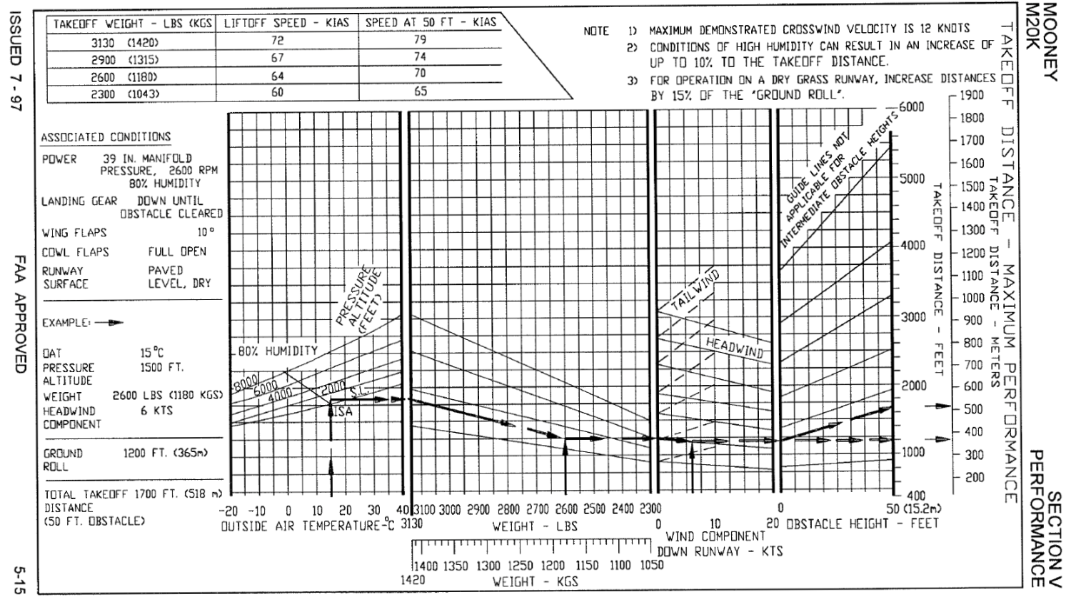
I looked back in my POH and noticed that the performance charts have a line that goes up to 10 kts for the tailwind component and stop. I take it that this was intentional, but not sure if this is similar to the 12 kts demonstrated crosswind that is "not a limitation"... Does anyone happen to know the history of this with the Mooney factory???
-
For those of you with the GFC500 AP, how many of you have already had to replace the servos with Mod1 servos? If you haven't had issues (but have affected SN servos), when are you planning on getting the servos replaced...do you replace them now, towards the end of the warranty period, or a specific time in between? From the service bulletin you have until 5/4/2028 to have these replaced under warranty. https://support.garmin.com/en-US/?faq=y ... iNr8uLLUA6 GSA28 extended warranty service bulletin info link if you need it. From Garmin FAQ: How will my Warranty be impacted? The standard warranty applies after the exchange of the servos. 6 months after the exchange OR the balance of your existing 2-year warranty applies, whichever is longer.
-
Colorado has a few mandatory tailwind if that’s what it takes. I.e. KGWS Glenwood Springs Rwy14/32 3305x50. To the north terrain rises quickly so the preferred approach is landing 32, departing 14. And for a mountain airport the runway is unusually short for Colorado. This is a place most pilots really have to do some calculations for. It’s also a great reason why a turbo Mooney is a great Colorado Mooney BTW Colorado Pilots Association puts on a great Mountain Flying Course every year. If you haven’t taken it, you absolutely should (the optional flight component includes a stop at GWS)!!
-
Picking up from paint shop, what should I look for?
Marc_B replied to thomas1142's topic in General Mooney Talk
@thomas1142 keep us posted on how things turned out! Has to be exciting to pick er up! -
So how about an AI interpreted Skew-T Log-P? Would be interesting to see how accurate (or not) an AI chart to text would be. Would it pick up the nuances? The biggest downside of the Skew-T is that it takes some education and experience to interpret, but it usually has good nuggets of info.
-
In my mind this isn't that much different than a practice approach or traffic coming in on instrument approach. But if at an uncontrolled field you have to be even more vigilant that you are watching and take into account aircraft without radios or ADS-B. It's one thing if it appears the pattern is light/empty (no radio calls, no ADS-B traffic). But if you see that the pattern is chocked full with ADS-b traffic, then that's another story. Personally I find straight in traffic with a full pattern usually not a safe option. If that's the case I'm usually overflying the field at ~1000 feet over TPA to get a sense for flow, then coming back around on a 45 entry with my best guess on spacing. Sometimes the better option is a straight in on the non-intersecting crosswind runway to avoid a packed pattern. Sometimes the best option is to come back in 15-20 min.
-
Major versus minor alteration; voltage regulator
Marc_B replied to Jetrn's topic in Modern Mooney Discussion
@Jetrn One other option that may be applicable. Mooney had a retrofit VR that for a while was offered by LASAR that I believe was the field adjustable replacement for the IAI regulator 800270-503. The downside for this was the cost. When I did my panel upgrade, I just had IAI service my VRs. But given that you're running into issues this may be an available albeit pricey solution. https://lasar.com/electrical-instruments/voltage-regulator-retrofit-replaces-800270-503-940170-503?rq=940170-503 From Mooney Retrofit Kit List: The Mooney Service Manual is pretty parsed about the VR other than giving specs for max voltage (28.3 +0.2/-0) and saying that the Mooney voltage regulator wasn't field adjustable. Although from the pic on LASAR website it looks like retrofit was also made by IAI...any chance they have one on the shelf and given the issues might give you a discount??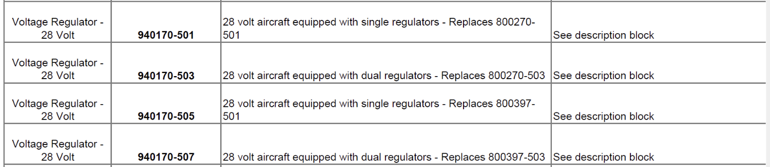
-
This is an interesting question...as I suspect: 1) if your AP is engaged, a trim switch malfunction would disengage the AP and run the trim, or 2) if your AP off, a trim switch malfunction would run the trim. BUT...the big take home is that the servo IS the autopilot. So in all circumstances pulling the AP breaker stops the problem. So my default is pull the breaker for the autopilot FIRST while holding the AP disconnect on my yoke. If you had one of the two events above, I might consider troubleshooting the issue and seeing if I could localize it to the trim switch. But I suspect that I'd probably just hand fly with the AP breaker pulled until I got on the ground.
-
Major versus minor alteration; voltage regulator
Marc_B replied to Jetrn's topic in Modern Mooney Discussion
@Jetrn I wonder if there is any chance that Ken Pethe (IAI) could speak with Don Maxwell to get your VR's overhauled given the circumstances? When I dealt with this before, I called Maxwell and he said he could overhaul them unless they were labeled IAI and if so they needed to be sent back to them. If there is an issue with getting this done at IAI, perhaps Maxwell's tech could still do it with approval from IAI?? Not sure the reason or background as to why Maxwell wouldn't service IAI VRs? I suspect that the boxes are simple electronics that could easily be serviced with the specs found in the Mooney Service Manual. I also called Zeftronics and Plane Power and they said they didn't have a 28V VR for a dual alternator system that would work in my Mooney...or perhaps they just said that as they didn't have one that was STC'd for the M20K dual alternator?? -
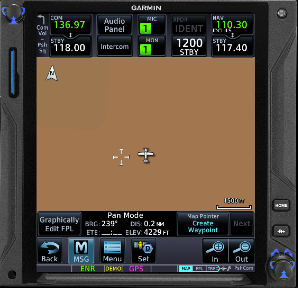
The two other ways I've added a user waypoint... From Home --> Waypoint Info --> Create Waypoint. From the Map you can touch an area of the map to enable either Create Waypoint & Graphically Edit FPL Regardless of how you start the process, it takes you to the same "Create User Waypoint" screen. There you can define the user waypoint by Lat/Lon, Radial/Radial, or Radial/Distance. If using the map page pointer, that data will be prepopulated on the best way it comes up to define that, but you can change to whatever you'd like...so if you're on the map page I just use that on the fly.

-
@201Mooniac exactly. No mention of a trim breaker as it is just the manual trim switch and doesn’t control the trim servo. The thread I linked was @PT20J’s description of testing pulling the trim breaker and the AP still ran the trim and the autopilot still functioned as before, controlling/trimming automatically. The only change was that the manual electric trim switch in the yoke didn’t function, and also important to note that the trim switch wouldn’t disconnect the AP like it usually would in that case.
-
Absolutely. It’s my understanding that with runaway trim with the GFC500 you must hold the AP disconnect and pull the AP circuit breaker. If you pull the trim breaker the electric trim from the AP still will run. if I have a runaway trim there’s no way I’d just pull the trim CB hoping the cause was the manual trim switch alone. But with pulling the AP breaker the servos are inactivated, because the GFC500 autopilot IS the servos. So pulling the trim breaker doesn’t depower the trim servo. If I’m understanding this correctly.
-
I only collared the AP breaker. The trim CB only controls the manual electric trim with the GFC500. But doesn’t affect the AP or the trim servo.
-
Cowl flaps : Landings and go-arounds
Marc_B replied to AJ88V's topic in Vintage Mooneys (pre-J models)
I’ve found that both gear and speed brakes both slow down by about 20-25 kts each. Cowl flaps slow by about 4-5kts. -
Can confirm with G500TXi and G5 that the baro syncs to the G5 when adjusted on the TXi, but for some reason doesn't go the other way...i.e. if I adjust on G5 then the baro doesn't change on the TXi and it highlights in yellow to tell you they don't match. With remote radio control enabled, you can control GTN 1 & GTN 2 freqs from either GTN as well as the TXi.
-
Do they make toggles with integrated circuit breakers? I have several rocker switches that are breaker switches. Might be a con for that application if so. Depending on your panel labeling, the wording on a wide switch may be easier to see. Black wording on a white switch is pretty easy to read. Also since the wording is on the switch rather than necessarily the panel, you can change/delete/add/move switches more easily in the future if needed without having to use sticker labels.
-
Sequenced behind slower aircraft then told to reduce speed
Marc_B replied to BravoWhiskey's topic in General Mooney Talk
I just saw an article about Danny Jansen playing for both the Red Socks and the Blue Jays in a single day (today I believe) due to a suspended game and being traded...and they quoted It's Always Sunny in Philadelphia..."I'm playing both sides so that I always come out on top!" -
Has the Mooney Caravan abandoned Mooneyspace?
Marc_B replied to Rick Junkin's topic in Mooney Caravan
Find a one and come join a clinic regardless. Probably would be a fun way to spend a weekend! Plus the clinics are always looking for more safety pilots!! -
My KFC AP was on the bottom, and my shop recommended up top with upgrade. I can see utility either way and both are just as accessible. You'll easily adapt to wherever you put it. So I think the reason this is a "contentious" discussion is just because it's more personal preference of location than anything. But for me, it's nice at the top as I can rest my fingers on the top of the bezel (it sticks out a little) or rest my hand on the glareshield coming up to a change. And in my mind, the GMC507 controller is in the same line as the G5 and the TXi. I like it up top and glad I put it there, but I never had a problem with my KFC on bottom either.
-
Has the Mooney Caravan abandoned Mooneyspace?
Marc_B replied to Rick Junkin's topic in Mooney Caravan
A lot can happen in 5 years and a bad event can be a catalyst towards good change. Sorry y'all have a bad impression of the Caravan. My experience has been drastically different. Camaraderie, proficiency, and fun. I’ve never felt unsafe with formation flying and the Caravan flight profile is the most basic formation flying that I typically fly. Three-ship Vic formation with half in route formation (2-3ship widths laterally). Sounds like the roots of the mass arrivals were informal gaggles or groupings of aircraft that may not have the same briefing or skills. Fortunately we’re light years past that. I don’t want to discount your experiences but my experience 2022/2023/2024 has been dramatically different. To each his own and may we all have lots of safe, fun flying adventures! Marc. -
This guy is an embarrassment to Mooney pilots.
Marc_B replied to Brandt's topic in Mooney Safety & Accident Discussion
I think this is because the safety improvement with the technology we are discussing are dependent on the pilot. Vs seatbelt and airbags in car that don’t have anything to do with how poor the driver is. So you won’t see improvements until you actually improve the pilot…which is the leading cause accidents in the first place. But the big question discussed above is if that technology encourages LESS training and airmanship, which would result in MORE accidents. Smart glide and auto land are steps towards an “airbag” type safety feature. (EDIT: I'd put Electronic Stability and Protection (ESP) and the blue LVL button in similar category) But I think most of the technology features today increase CAPABILITY more than safety. Two entirely different feature sets, but easy to confuse the two. -
Has the Mooney Caravan abandoned Mooneyspace?
Marc_B replied to Rick Junkin's topic in Mooney Caravan
FWIW, I think the accident in 2019 is an outlier and there are no longer any inflight configuration changes...we brief the flight and everyone flies the brief. But we all make our own decisions for ourselves and I'm not trying to convince someone who doesn't want to fly to Osh or in the Caravan to join. As an aside, I work in the ER and see horrible car accidents every shift. The risk going down the highway is rife with WAY more mid'grounds! I'll take flying in the Caravan beside my squadron mate any day! -
Sequenced behind slower aircraft then told to reduce speed
Marc_B replied to BravoWhiskey's topic in General Mooney Talk
When I was flying back from Osh this year I stopped for lunch and met up with another M20K driver. We both left IFR and he left just before I did, but was loaded more heavily. We were both flying back to CO, but I was heading to GXY so I filed YOKES as my last waypoint as I've found that keeps Denver from giving you a reroute STAR. Unfortunately Jordan didn't do this and I had passed him by the time Denver gave him a reroute "cleared direct YOKES then direct destination." So they asked me what my speed was, then came back to Jordan with a speed restriction for 10 kts less! I was close enough to home that I asked for a descent thinking that I'd keep the power up and rocket down to create more separation so they'd remove his restriction...ATC was amazing in that they they gave Jordan a descent as well...WITH A SPEED RESTRICTION. I was laughing hysterically and imagining the cursing going on in the Mooney behind me. I kept waiting for Jordan to tell ATC "I'd like to cancel IFR immediately", but I think he wanted the instrument practice. I guess it is true...it pays to be the winner!


