
rbp
-
Posts
1,308 -
Joined
-
Last visited
-
Days Won
3
Content Type
Profiles
Forums
Blogs
Gallery
Downloads
Media Demo
Events
Everything posted by rbp
-
Need a *local* ferry pilot for a long-body mooney in/near northern NJ
rbp replied to rbp's topic in General Mooney Talk
local pilot for local flights in/near NJ preferably a CFI, but commercial certificate and airplane-instrument rating with 1,000 hours and 25 in type (M) -
Need a *local* ferry pilot for a long-body mooney in/near northern NJ
rbp replied to rbp's topic in General Mooney Talk
in around New Jersey -
Please advise
-
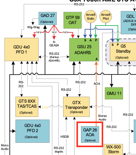
For those of you who have a 3GX panel, did you also install the GAP 26 AOA? what is your experience using it?
-
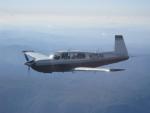
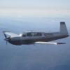
Here's are the latest details on the plane: https://www.facebook.com/N2154X
-
take-off: full power / full rich climb: 34/24/rich @120 cruise: 30/24/1550TIT/<400CHT hottest cyl in cruise on descent, I fly under the yellow arc (or as appropriate given turbulence), and lean the engine to keep the temps up. then richen 1 turn per 1000' to cool the engine. 20" on approach / pattern penetration / wheels down in level flight 17" wheels down descent to the runway
-
I took the plane off the market, and it is now for sale again
-
reviving this topic. have any of you considered the certified version of the Garmin G5 as a backup? its only $2K
-
1kt of airspeed = 100ft of tarmac be on speed for your weight!
-
my Bravo is for sale, but not because I don't love flying it http://mooneyspace.com/topic/14400-1998-mooney-m20m-for-sale/
-
except for the accelerated stall on pull-out! it happens real fast, and you can see the whole plane shake
-
Plane prices and 3rd class medical change
rbp replied to Bob_Belville's topic in Miscellaneous Aviation Talk
some of the people who have SIs have been saying that if the rule passes, they are going to let the SI expire, without a new physical, and fly under the new rule -
I think you'll find the Bravo owners here will be happy to answer any questions you might have.
-
Instrument / Equipment required for Private IFR flight?
rbp replied to Tommy's topic in Miscellaneous Aviation Talk
exactly the same way you do. but that subsection can't be read in isolation, the text preceding it says "Subject to the operating requirements in this AC". if all I read was subsection (1)( b ), then I wouldn't need to use an IFR-certified GPS, would I?, because the requirement to use an IFR-approved GPS appears elsewhere in the regs You can't cherry pick one sentence and ignore the rest of the reguations. -
Instrument / Equipment required for Private IFR flight?
rbp replied to Tommy's topic in Miscellaneous Aviation Talk
it says "Subject to the operating requirements in this AC" and its in those exact operating requirements that you'll find the rules I quoted -
Instrument / Equipment required for Private IFR flight?
rbp replied to Tommy's topic in Miscellaneous Aviation Talk
there are a lot of things that will work that are illegal. for example, you could probably land safely using the GPS for a VOR approach, but its not legal without an overlay -
Instrument / Equipment required for Private IFR flight?
rbp replied to Tommy's topic in Miscellaneous Aviation Talk
sorry, let me rephrase: I have provided three separate references that specifically say that DME distances cannot be used for approach mode; the DME-based procedure must be loaded from the database, and the named 5-letter fixes must be used. the reason you need to set the GPS to approach mode is because it increases the RAIM sensitivity and prediction appropriately. You're right about setting CDI, but not for the reason you said: only some GPSs will increase the RAIM prediction when the CDI is set to .3. -
Here is a list every Bravo on the market in this age range MY airplane s/n 0243 has the lowest price tag and is the #2 in terms of equipment and condition. S/N 289 has a better panel and is $12K more.
-
Instrument / Equipment required for Private IFR flight?
rbp replied to Tommy's topic in Miscellaneous Aviation Talk
OK, i give up but just as a reminder, those of you using GPS-in-lieu-of-DME on approaches requiring DME, but without loading and activating the procedure, please make sure you've set the GPS to approach mode, or at least CDI 0.3nm -
Instrument / Equipment required for Private IFR flight?
rbp replied to Tommy's topic in Miscellaneous Aviation Talk
you can select the navaid as a WAYPOINT but you cannot identify and navigate to a point in space on your route as "22.1 miles from MOD VOR." You have to use ZADBA. -
Instrument / Equipment required for Private IFR flight?
rbp replied to Tommy's topic in Miscellaneous Aviation Talk
>If the approach is something like a VOR/DME with no mention of GPS anywhere on the approach plate then you may use GPS "in lieu of" the DME. In that case you only need to load the DME fix. this is false. first of all, there are no approaches like "VOR/DME with no mention of GPS anywhere on the approach plate": all terrestrial navaid approaches that require DME have intersections co-located with the DME fixes. For example, this TCY VOR/DME 26 approach shows: (source: http://155.178.201.160/d-tpp/1503/05815VD26.PDF) and if you are using GPS-in-lieu-of-DME, you must, as per AC 90-108, use RW26, ZADBA, SIGBY, and WIBAG to identify the stepdowns and MDA. you cannot use MOD + DME distance AC 90-108 you cannot identify DME waypoints required for an approach procedure by using the DME fix + distances. you have to use the DME waypoints loaded into the GPS. -
here's another: a flat spin. boy are we spinning!
-
Instrument / Equipment required for Private IFR flight?
rbp replied to Tommy's topic in Miscellaneous Aviation Talk
I will say this a third time If you want to locate a NAVAID, like a LOM, you can do that with the GPS. If you're flying a VOR/DME, ILS/DME, ADF/DME (yes, they exist), or an approach that says "DME required", and you are using the terrestrial NAVAID as your primary means of navigation, you must load the overlay procedure into the GPS unit, and use the co-located DME fixes. You CANNOT use "Direct To: DME + distance to identify the DME fixes. -
Instrument / Equipment required for Private IFR flight?
rbp replied to Tommy's topic in Miscellaneous Aviation Talk
so OK, I have to load HEMAN from the database. that means I also have to load DIVEC, PONKE, WETOR, ROKME, DUYET, and NEPIC in order to fly the approach. what have I just done? i've just hand-entered the approach (hopefully in the right order) into the GPS. this is one practical reason you have to load the procedure. the second practical reason is that there are many DME fixes which are not unique in the database, and can ONLY be loaded with the procedure. For example, the TCY VOR/DME RWY 26 approach has a MAP DME fix called RW12, which is 23.1DME from MOD. You cannot identify the MAP using GPS in lieu of DME without loading the whole procedure. TCY VOR/DME RWY 26: http://155.178.201.160/d-tpp/1503/05815VD26.PDF and GGW RNAV (GPS) RWY 12: also has a RW12 fix: http://www.globalair.com/dtpp/globalair_05382r12.pdf so you can take the position (which I disagree with) that reg-wise, you don't have to load the procedure. but how would you fly GPS-in-lieu-of-DME in these two situations without doing do? -
Instrument / Equipment required for Private IFR flight?
rbp replied to Tommy's topic in Miscellaneous Aviation Talk
From the AOPA link: If you look at an an approach plate, you will see that every DME-based waypoint has a fix name. As per above, you can only use the fix name, as specified above, not the distance from the DME GPS database waypoint. For example, the SFO ILS 28L, HEMAN INT corresponds to I-SFO 12 DME. You cannot use the distance from the I-SFO DME navaid on the GPS, you have to use HEMAN. SFO ILS 28L: http://155.178.201.160/d-tpp/1503/00375IL28L.PDF
