Scott Dennstaedt, PhD
-
Posts
456 -
Joined
-
Last visited
-
Days Won
3
Content Type
Profiles
Forums
Blogs
Gallery
Downloads
Events
Store
Everything posted by Scott Dennstaedt, PhD
-
There’s no eBook available yet. Only soft cover. Possibly by the end of the year. Good podcast about the book released recently on Aviation News Talk.
-

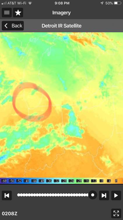
Why is Quantico forecasting a dust storm?
Scott Dennstaedt, PhD replied to ShuRugal's topic in Miscellaneous Aviation Talk
Hmmm? TAFs don’t have states in them to decode and the area forecast is retired. So I am at a loss as what forecast that is decoded that has states listed. Perhaps NOTAMs? -
Why is Quantico forecasting a dust storm?
Scott Dennstaedt, PhD replied to ShuRugal's topic in Miscellaneous Aviation Talk
Which forecast did you see this? -
Why is Quantico forecasting a dust storm?
Scott Dennstaedt, PhD replied to ShuRugal's topic in Miscellaneous Aviation Talk
Are you referring to a forecast (TAF) or an observation (METAR)? If it's a TAF, my guess is that the TAF decoder is erroneously picking up on DS in the remarks section, AMENDS. Basically tells users that there will not be any amendments to the TAF after 15Z on Dec 28th. I believe the remark suggests the next TAF that will be issued is on Jan 2nd at 09Z. TEMPO 2909/2912 VRB06KT T14/2820Z T06/2912Z LAST NO AMENDS AFT 2815 NEXT 0209= -
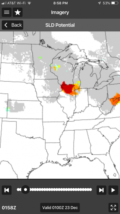
That's correct. Unlike the CIP or FIP, the SLD is a potential field, not a calibrated probability. Any likelihood of SLD that's greater than 5% will show up on the Aviation Weather Center severity charts. In WeatherSpork, we show the actual scale...so in this case, it's a high likelihood given the red color. This was prompted by the rather warm, subfreezing cloud tops and the freezing drizzle potential at the surface. All of this means a good signature that there's an altitude or two that you want to avoid (below 5K MSL). There were a bunch of reports of moderate ice and one report of severe ice between 3.5 and 5K MSL.

-
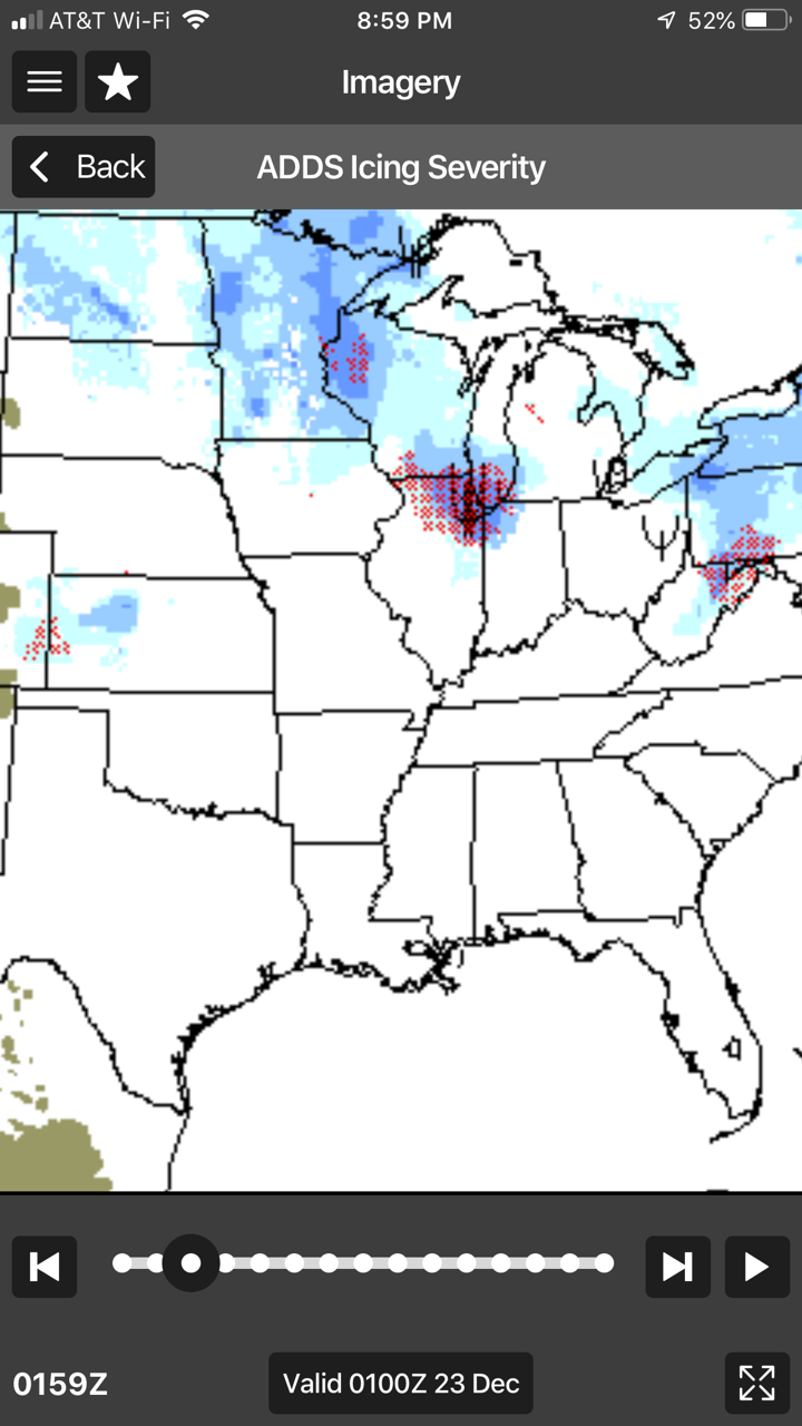
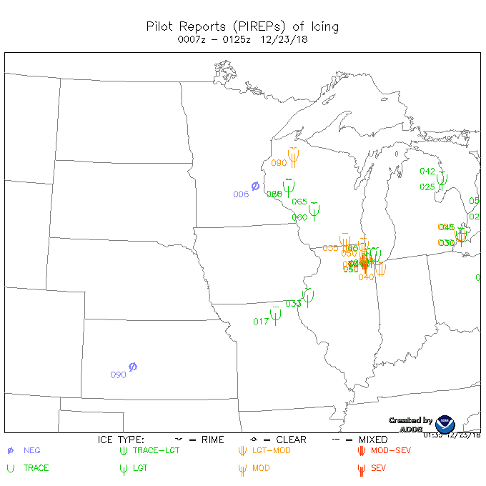
Below is an icing severity analysis (CIP severity) as shown in the WeatherSpork app. You can also get this from the Aviation Weather Center website under the "Severity + SLD" and by selecting the 0 hr forecast (analysis). Notice the red-hatched area around Chicago from the satellite thread I started. That is the Supercooled LARGE Drop (SLD) threat valid at the top of the most recent hour. What does this tell you or not tell you about the icing threat in this area? The devil is in the details, so be specific.

-
Nice observations. Actually the pale greens will also tell you that the cloud is likely dominated by supercooled liquid water. Colder tops don't really tell you much about what's happening below, but often these higher clouds will be mostly ice crystals. Those tend to fall into the lower clouds and will often "seed" the clouds below turning lower clouds into a more mixed phase variety (and maybe lessening the icing risk). In this case, there are no higher clouds, so the ability to seed them isn't there. Another reason I'm confident these clouds are nasty ice makers.
-
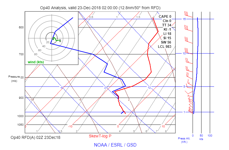
That's a great suggestion given that this time was right around the 23Z launch time...however, the closest radiosonde is DVN which is 120 miles away from Chicago or GRB which is 150 nm from Chicago. Unfortunately, neither one of these will be a good representation of what's happening in Chicago.
-
The cloud top temperatures in this image tell you a lot about the phase of the moisture in the cloud. Clouds with tops that are warmer than about -15°C are likely to dominated by supercooled liquid water. I can also tell these clouds are highly capped by an inversion without knowing the temperature profile. Moreover, depending on the environment, it also may be dominated by SLD. This SLD Potential analysis from the WeatherSpork app shows a high likelihood of SLD in this region. This is an environment that will also typically produce freezing drizzle KRFD 222337Z 2300/2324 VRB03KT P6SM OVC015 TEMPO 2300/2302 5SM -FZDZ BR OVC009 FM231200 27009KT P6SM OVC020 FM231900 27009KT P6SM SCT025 BKN035 And, the NWS forecast was right on the money with FZDZ reported at the surface. This was a forecast that was issued at 2333Z. KRFD 230254Z 29009KT 6SM BR OVC012 M01/M03 A3004 RMK AO2 FZDZE31 SLP181 P0000 60000 I1000 I3000 T10111033 51016 KRFD 230237Z 29007KT 6SM BR OVC012 M01/M03 A3004 RMK AO2 FZDZE31 P0000 I1000 T10111033 KRFD 230154Z 29008KT 6SM -FZDZ BR OVC013 M01/M03 A3003 RMK AO2 FZDZB54 SLP178 P0000 I1000 T10111028 KRFD 230141Z 28006KT 6SM BR BKN014 OVC022 M01/M03 A3003 RMK AO2 T10111028 The RFD sounding analysis shows the unstable cloud structure that is capped by the temperature inversion.
-
What does this satellite image tell you about the icing threat in the Chicago area?
-
My weather pet peeves
Scott Dennstaedt, PhD replied to Scott Dennstaedt, PhD's topic in Miscellaneous Aviation Talk
Amen! Having been there and done that on a gov't salary, raising a family and barely making ends meet, it can be an extreme hardship without the continuous cash flow. -
My weather pet peeves
Scott Dennstaedt, PhD replied to Scott Dennstaedt, PhD's topic in Miscellaneous Aviation Talk
You need to stop watching the local news and actually looking at the real NWS forecast which had a accurate prediction. Read the discussion and you will have a better appreciation for the difficulty these meteorologists have sometimes. And now they will be working for free due to the government shutdown. -
My weather pet peeves
Scott Dennstaedt, PhD replied to Scott Dennstaedt, PhD's topic in Miscellaneous Aviation Talk
What forecast are you using from the NWS? Here's the aviation forecast. Says nothing about hail or thunderstorms. After 06Z the possibility of showers in the vicinity until 12Z. KHOU 192336Z 2000/2024 31006KT P6SM SCT015 TEMPO 2002/2006 BKN015 FM200600 32007KT P6SM VCSH SCT007 OVC015 FM201200 31015G25KT P6SM SCT250 Appears to be an excellent forecast with some light rain around 10Z or so. KHOU 200953Z 29006KT 8SM -RA BKN014 BKN026 OVC035 13/12 A2979 RMK AO2 RAB07 SLP093 P0002 T01280117 KHOU 200907Z 29005KT 7SM -RA BKN014 BKN022 OVC038 13/12 A2979 RMK AO2 RAB07 P0000 T01280117 And at IAH light rain from 07Z to 11Z. Again a pretty darn good forecast from the NWS. KIAH 201053Z 31008KT 10SM -RA SCT010 BKN050 OVC080 13/12 A2980 RMK AO2 RAB36 SLP093 P0001 T01280122 KIAH 201038Z 31008KT 10SM -RA SCT015 BKN055 OVC120 13/13 A2980 RMK AO2 RAB36 P0000 T01330128 KIAH 200853Z 29005KT 10SM -RA FEW009 BKN025 OVC050 12/12 A2979 RMK AO2 RAB05 SLP088 BKN025 V SCT P0001 60005 T01220122 53002 KIAH 200843Z 29005KT 10SM -RA FEW005 BKN025 BKN060 OVC130 12/12 A2979 RMK AO2 RAB05 P0000 T01220122 KIAH 200653Z 30003KT 10SM -RA MIFG BKN018 BKN040 OVC080 12/12 A2978 RMK AO2 RAB48 SLP086 P0000 T01220122 KIAH 192336Z 2000/2106 00000KT P6SM SCT013 TEMPO 2002/2006 BKN015 FM200600 31006KT P6SM VCSH SCT007 OVC015 FM201200 32015G25KT P6SM SCT250 FM210200 31010KT P6SM SKC -
My weather pet peeves
Scott Dennstaedt, PhD replied to Scott Dennstaedt, PhD's topic in Miscellaneous Aviation Talk
Craig, Thanks for the kind words. Next lesson is that it's the SkewTLogPro app. Chad Sandstedt did a great job developing that app (although many folks think I developed it...similar looking last names I guess). He's not a Skew-T expert at all so I'm not looking for much more significant stuff to come out of it. In WeatherSpork we will be growing our own Skew-T and I've got some really useful stuff planned for it. It'll be the coolest depiction of a Skew-T ever. I would also direct you to the WeatherSpork YouTube channel...subscribe to the channel and you'll also get some great education there as well. Not all of it is about WeatherSpork. If there's a specific weather topic you'd like to discuss, feel free to bring it up here and tag me and I'll do my best to weigh in on it (without writing a dissertation on the subject...extremely busy these days with developing the app and finishing up my PhD). -
My weather pet peeves
Scott Dennstaedt, PhD replied to Scott Dennstaedt, PhD's topic in Miscellaneous Aviation Talk
The AFDs are great to read, but they are highly technical at times since they are meant to be a forecaster-to-forecaster discussion. Forecasting is not blacks and whites, it's always shades of grays...so forecasters have to quantify their uncertainty. Much of this is by comparing the solutions from various forecast models, GFS, GEMS, NAM, RAP, HRRR, CMC, ECMWF, UKMET, SREF, etc. When I was working as a research meteorologist, my specialty was numerical weather prediction modeling. So, I know a fair amount about this. My favorite to read is the Model Diagnostic Discussion from the WPC. There's one meteorologist that looks at all of the models and tries to sort out what models are doing well and what models are not...then he/she writes up the discussion and forecasters all over the U.S. will take some time and read it. Kind of prevents forecasters all doing the same thing. Now, they are free to disagree, but most of the time, this person is an expert at this and usually gets it right. But as with anything, some of the model preferences may also come down to geographic location. Often, they will suggest a blend of two or more models. Models have known biases and a good forecaster can correct for it. Sometimes all the models have a good handle on a weather system, but it's timing differences that can matter significantly. Much of the modeling is going towards ensemble forecasts that produce means, medians and standard deviations. Again, the forecaster is looking to see consensus and blending models through ensemble forecasts can produce a better result. Windy app has some good visualizations. Some of this is very gee-wiz kind of stuff that has little or no meaning to pilots other than to wow us. But deep down, there are some pretty nice features...many of which we are planning to develop (albeit, different) into the WeatherSpork app. -
My weather pet peeves
Scott Dennstaedt, PhD replied to Scott Dennstaedt, PhD's topic in Miscellaneous Aviation Talk
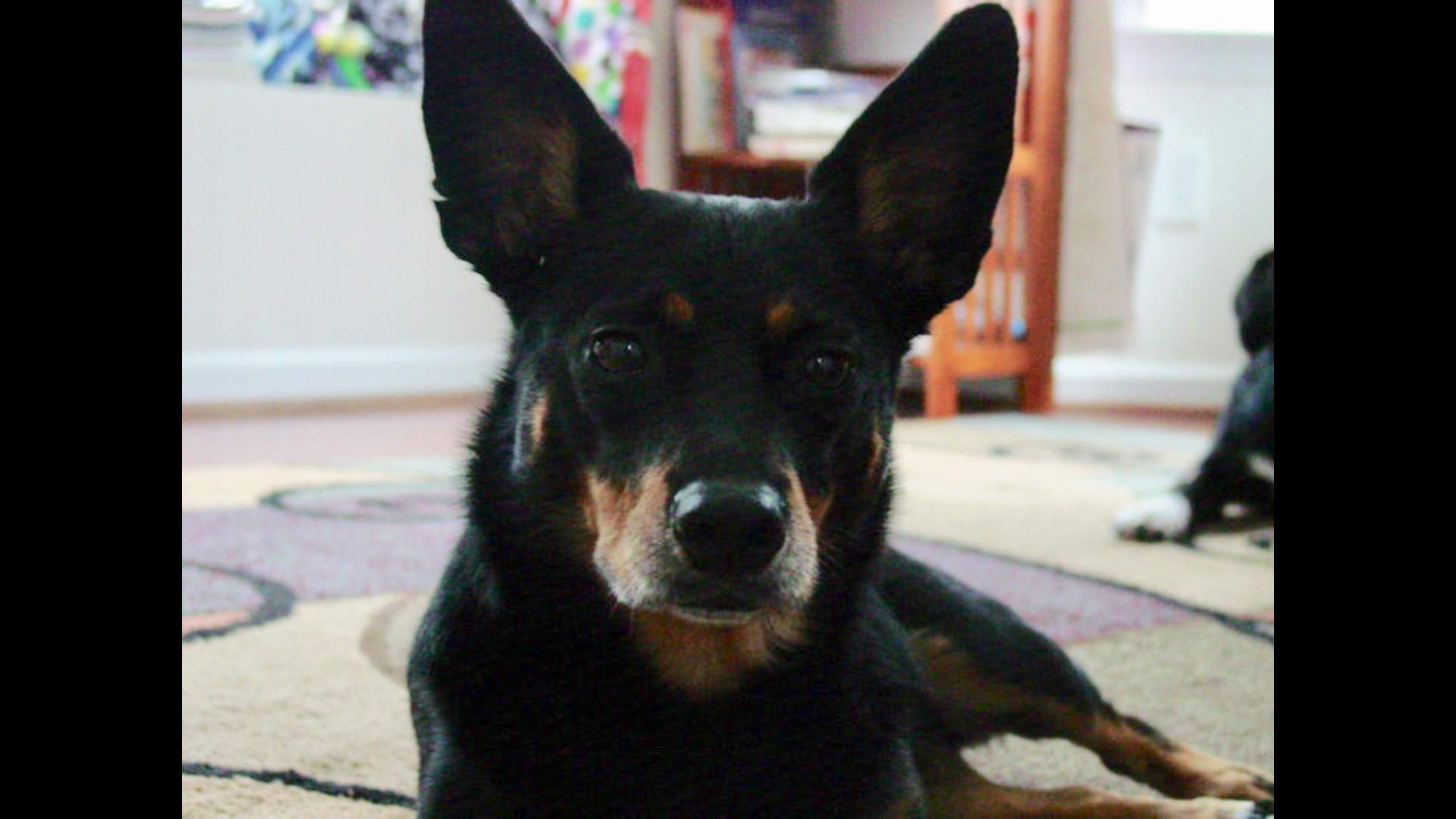
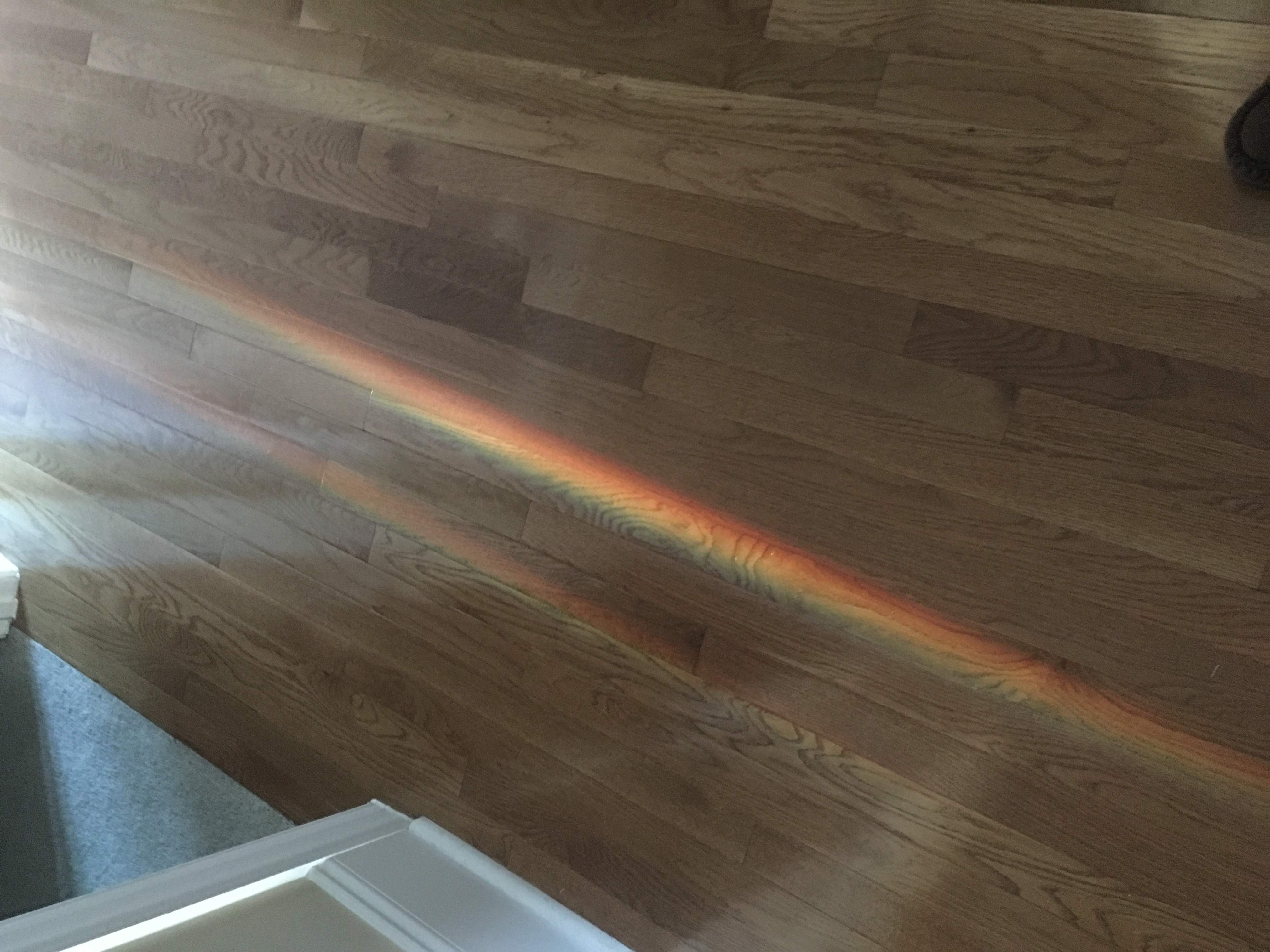
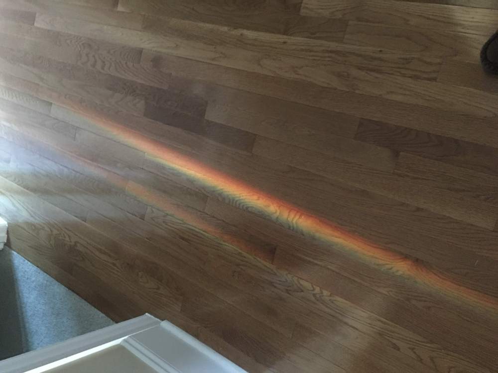
Even as a blind dog for the last 7 yrs she always managed to find her way back to my home office and faithfully laid next to me every day as I worked. She had the most unique personality. Unfortunately, my pup had a stroke last week and developed a vestibular or cerebellar dysfunction (a form of vertigo). She tried very hard to be a normal dog again and I was rooting for her every minute. But it was a bit too much for her and she had a horrible quality of life. The most difficult decision I’ve had to make. And the very next morning this “double rainbow” of sorts appeared deep in my house pointing right to the place where she laid every day letting me know she was at peace and doing okay.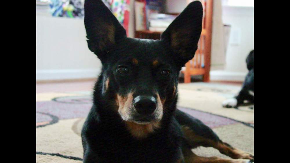
-
My weather pet peeves
Scott Dennstaedt, PhD replied to Scott Dennstaedt, PhD's topic in Miscellaneous Aviation Talk
Ah, that's okay - I'm disappointed every day with something. That's why they are MY pet peeves. But I know the feeling. I once had a Pilotworkshop customer purchase a workshop that I licensed them to sell and he wrote an email to me complaining that he didn't know if he could make it through the program. Not because of the challenges of the content, but because I am from Baltimore and pronounced "across" as "acrost" or "etc" as "ac-setera" and the list went on and on. Turned out later that I discovered he was a professional speaker (did radio commercials and such). I put in so much effort to this program and all this guy could do was complain about my "Balmore" accent. Ugh! Some things drive me crazy. But you did notice that I started with the small and meaningless stuff and worked my way to the more substantial pet peeves. Oh, by the way, I'm still getting over having to put my 14 yr old dog down on Saturday. Perhaps that's part of it too. -
Okay, so we are approaching the end of the year and it tends to bring the resolutions to do better in the new year. Get that new exercise equipment, go on a diet or perhaps learn more about aviation weather by reading a new book called Pilot Weather: From solo to the airlines Anyway, thought I'd share just a few of my weather pet peeves... 1. Lightening. There's no E in lightning. 2. Turbulance. There's no A in turbulence. 3. Cumulous. There's no O in cumulus. 4. Forcast. There's an E in forecast. 5. Wind sheer. There's an A in wind shear. 6. The word misspelled is the most misspelled word (okay, not a weather term, but still true). 7. The following two statements have always been perplexing to me... (a) "It's better to be on the ground wishing you were in the air, than in the air wishing you were on the ground." (b) "It's never a bad decision to cancel." So, there's no harm to making a conservative decision in marginal weather...as long as it is based on a solid analysis of the weather. If you are finding that your conservative decisions are actually days where you could have easily flown, there's something awry. You can't have your cake and eat it too. If you are making less than stellar conservative decisions, one of these days, it'll bite you when actually fly and you should have stayed on the ground. No, you don't have to beat yourself up, but make it a point to learn what happened. Was it a bad forecast, or more likely, was it a bad understanding of the forecast? 8. "Ice is where you find it." As if airframe ice is always a surprise. If you really take the time to understand what conditions ice is likely, it should never be a surprise. It is true that only 80% reports of icing occur within the boundaries of an advisory, but note that much of that 20% may not be forecast because it doesn't meet specific criteria. For example, it may be convective icing (G-AIRMETs are nonconvective icing) or light icing (G-AIRMETs are for moderate ice). 9. "Forecasts are just educated guesses." Well, yes, but there's a ton of truth you can extract from those imperfect forecasts. Most of that comes from understanding the synoptic overview or "big weather picture." It's the consolidation of all of that guidance that truly should drive your decisions. 10. "The datalink radar depiction could be 20 to 30 minutes old." It could be, but that's not the norm. It's likely no more than about 10 minutes old from what you see outside of the cockpit unless you've missed an update. And with the twice as fast updates with SiriusXM, composite radar and lightning are usually no more than 7-8 minutes old in the worst case. Even so, it should only be used for strategic avoidance and should never be used for tactical decisions (in the next 30 seconds to 2 minutes).
-
That's correct Mike, I retrieved it from my app...sorry for my poor english...it ain't too good sometimes.
-
Bob, I pulled the Skew-Ts out of my WeatherSpork app, but you can also get them from http://rucsoundings.noaa.gov. The NOAA site has been operational since about 1997 or so. The site you are using are satellite-based soundings from GOES.
-
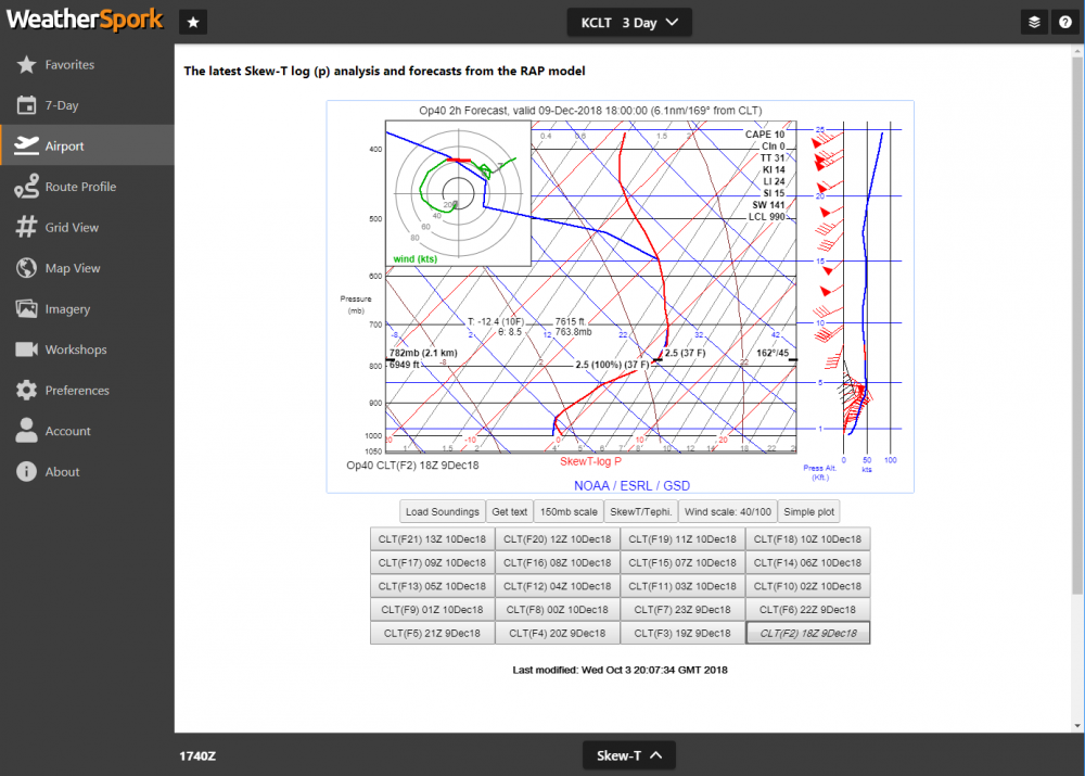
Jeff, Here's what I said... "Notice that the lapse rate beginning at 8K nearly follows the moist adiabatic lapse rate." That's the MALR, not DALR. Yes, when the atmosphere is saturated (as it is here) and the environmental lapse rate is moist adiabatic (follows parallel to the MALR), then it's the most unstable as it will get. Instability means there's a large change of temperature with height. Yes, the curved "brown" line is the MALR reference line (see below). In this case, the environmental lapse rate is at its greatest between 8K and about 10K. The more the line leans to the left, the more unstable the atmosphere. So there's a stable or nearly isothermal layer below this (below 8K). I've flown into an area like this before (through the Richmond, VA area) and it feels like you are driving a car fast over an endless road of speed humps.

-
Alex, In my experience, unless you are doing your checkride for a glider rating, no, most DPEs don't even know about a Skew-T diagram. Now, if they ask you, "How do you determine the freezing level along your proposed route?" you could say, "I use a Skew-T diagram to help make that determination." Or if you are a WeatherSpork user, you could show the examiner the profile view that depicts the freezing level along your entire route (dotted blue line).
-
Jeff, Instability is all about lapse rate. Large lapse rates means unstable air. Notice that the lapse rate beginning at 8K nearly follows the moist adiabatic lapse rate. That's the largest lapse rate Mother Nature can dish out in saturated conditions. You can find this article I wrote in IFR magazine many years ago that discusses lapse rates that should help.
-
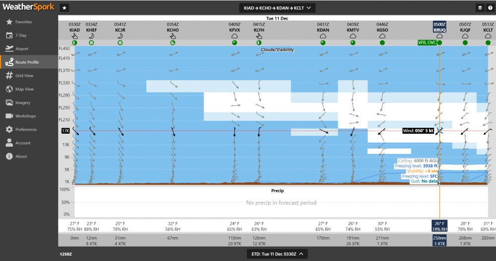
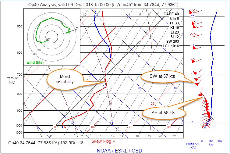
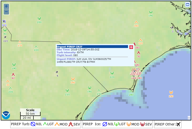
If you are not a Skew-T fanatic, you should be. Here's an excellent example of what the Skew-T can do for you. Take a look at this Skew-T analysis from 15Z in southeastern NC. Notice at about 6,500 ft MSL, the winds are from the southeast at 58 knots and then around 9,300 feet, they are from the southwest at 57 knots. This is an excellent example of directional shear in the wind aloft. The key though is the moist unstable layer that starts just below 8,000 feet that enables the air to mix. All of this coupled together is the reason this pilot reported extreme turbulence at 8,000 feet MSL. If you are not a Skew-T fanatic, make a New Year's resolution to become one!
-
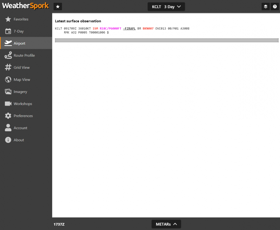
Looks like I got two out of the three precip types right. Not going to mix in snow because the warm nose turned out to be too warm. So, just -FZRAPL. This shows, however, that it is snowing aloft, but the snowflakes are partially melting and refreezing into little nuggets. Overall in the S. Charlotte area, this turned out to be a very cold rain for the most part. Got some moderate ice pellets overnight, but nothing really to write home about.