midlifeflyer
-
Posts
4,350 -
Joined
-
Last visited
-
Days Won
18
Content Type
Profiles
Forums
Blogs
Gallery
Downloads
Events
Store
Everything posted by midlifeflyer
-
Maybe not that extreme, but when I see a thread by a pilot who is asking questions as part of an obvious attempt to teach themselves, I cringe. OTOH, when asked, many of them say they can’t find a CFI who understands what they have enough to teach it. Love him or hate him, I have to applaud Gary Reeves for focusing on “avionics mastery” as a career. It’s probably 80% of what I do with owners - for some strange reason it all makes sense to me - but I’m too old for a new career
-
It’s a learned response. The typical sequence is to press it when you add climb power. In G1000 integrated setups with a non-vernier throttle quadrant, the button is actually on the throttle. I think the 7° selection is a compromise to give you a pitch attitude that will result in a safe climb whether you or the AP follow it. If you don’t have one, chances are that it’s what you are doing anyway. One of the sad realities is that, like go-arounds, we don’t do missed approaches enough. . Every missed begins with a straight ahead climb. It “should” be simple. But that’s exactly where the errors are incurring, TOGA displaying the proper attitude is just another of the attempts to have tech fix that by displaying a magenta chevron for the pilot to follow. Your fear is not unreasonable. When I do transition training with a GFC 500 “system”, where the AP remains coupled, one of the demos is to fly a coupled approach all the way into the missed hold with the pilot controlling only power flaps, gear, and autopilot modes. Even then, it can take a while for the disbelief to go away.
-
TOGA is a function of modern Garmin autopilots (GFC 500, 600, 700). Its purpose isn’t to fly the airplane for you. What it does is create a wings-level climb on the AI’s flight director (assuming you have one) for the pilot (or autopilot) to follow. Basically, a magenta chevron on the AI to follow. It also unsuspends the navigator and sequences it to the missed approach. The pitch attitude varies by airframe, but in most GA aircraft it’s in the 7° nose up range. (If you’ve never flown with a flight director, chances are you won’t miss it. Pilots transitioning to an airplane with one often have trouble getting used to it. Once they do, it becomes a valuable tool in maintaining the proper attitude in all phases of flight) What varies a little is what else TOGA does. In the 500 and 600, the autopilot remains coupled (assuming you used the AP for the approach). In the 700, whether it disengages the AP or keeps it on depends on how the airframe manufacturer wants it set up. As mentioned, in the Mooney G1000, TOGA disengages the AP. In either case, the pilot is responsible for power, flaps, and gear. At its most basic, it requires an AP which has it, an AI with the ability to have a flight director
-
If I'm flying with a GTN or G1000, yes, except for the DA/MAP. Displaying waypoint altitudes is part of VNAV capability.
-
To be fair, Hank, while I disagree with Jack, avionics use really has very little to do with the airframe. If I’m teaching operating practices for [pick you favorite avionics setup] whether it’s a Mooney or a Diamond, or a Cessna, or a Bonanza, or a Piper or a Tecnam or something I haven’t been in doesn’t really make any difference. What you do with the airplane, definitely. But what you do with the box, no.
-
I’ve been hanging out in online groups almost as long as I’ve been involved in aviation, back to the rec.aviation usenet groups in the 1990s. I have learned an incredible amount from them but have also seen a a lot of BS. Bottom line, I think in any online group, one has to be discerning. Separate the wheat from the chaff. Opinion from verifiable fact. Requirement from preference. Trust but verify. Most every discussion with different viewpoints will ultimately devolve into nonsense. Insults, challenges to competence and its reverse, unsolicited statements of credentials intended to claim nonexistent authority, tit for tat, and the like. There are clues. You can join in the fun and games or move along to another discussion As far as I can tell, MooneySpace has not gone downhill. Specific threads will. Even in the best of places.
-
Well, since you feel free to violate my First Commandment, I will pay no attention to you. Really. . After what that experienced CFII (he was also a controller) did to me - something that took several years to fix - I have zero respect for that attitude. If I see some technique is causing a problem, I will suggest they try something I think is better. It's actually pretty easy to test. I pretty much do one of those on every recurrent (as opposed to primary or transition) training flight. Nothing fancy. For a wicked simple example, if I see someone using VTF (which I never use), I'll just put them into a situation where it causes a problem. Deer in the headlight? We have something to discuss. Fixes it in 8-10 seconds with no hesitation? I see no reason to mess with it. With my list of GPS tasks pilots have trouble with, I'm not going t waste my and and client's time fixing something that ain't broken. Sorry you feel the need to do that.
-
You are likely not a candidate for an in-ear headset. On a related tangent, there was a thread in another forum that asked whether anyone has tried to wear two headsets - a domed ANR over an in-ear. So, of course :D, I couldn't resist trying it. Not my Lightspeed (where I would have two mics in the way of each other), but a headset I use to listen to music at the gym or while on an airline flight. It was comfortable but I found the combination to be too quiet.
-
…and the one I tried was about 3 years ago. I know the Halo is popular enough that many are simply not having the issue. Others may be so used to the brief touch when communicating. And it’s noise attenuation is excellent which is why the tube-and-multiple tip concept is being used by several other manufacturers. I have no horse in the race, so I don’t discount others’ experiences just because they are different than mine.
-
You are describing a crew environment, which is different in many ways. You are talking about “jotting down mins, “ a step I stopped doing when they were done for me on the EFB (well before either Dynamic Procedures or SmartCharts) ”why did we brief this thing if you can just look at the FMS (or GPS) and pull it from there?” You may brief to memorize. I don’t. I learned a personal limitation in retaining numbers ages ago. So, my briefing is more about setup and situational awareness that numerology and my answer to that is, “because my memory isn’t perfect so I’m cross-checking.” My avionics? Pretty much everything from analog to glass from multiple companies, navigators/FMS from Garmin and Avidyne, and autopilots from King, STEC, Garmin and others I can barely remember. I’m not sure why you want to drill down. Is it that really that hard to accept that pilots use multiple techniques that work? Or are you like the CFII I encountered years ago who led me to come up with my First Commandment of Flight Instruction before I ever became a CFI? “Thou shalt not try to force a change in a pilot technique that works just because you happen to like another one better.”
-
I would never even think of using an iPad for primary navigation absent an emergency. yes, to each their own preferences.
-
I will switch the screen off often enroute to save battery and lessen the heat. But it's on in the approach environment for several reasons, which may depend on what equipment I'm flying. Here's a few. YMMV. I don't attempt to memorize the approach, so it's a bit of a security blanket whether I actually need it or not. It's my moving map display. I want to see traffic. I can pop in a "direct" to the airport and get an instantaneous distance read out for traffic calls while leaving the real flight plan intact. I think it's important to see the airport diagram appear after landing. I was doing the same thing with approach charts when I was using paper and see no reason to change a 30+ year old SOP. It takes more effort to remove it from it's cradle and stow it than to leave it alone.
-
Perhaps. I'm just relating what I (and others) have seen and experienced. I'm not the only pilot who switched for that reason. Three's a reason it's a talking point for competitors. One of the more famous switchers before the switch.

-
I can think of one reason to avoid the Halo. The floppy microphone. I tried a Halo and got rid of it because every time I made a transmission, I had to push the mic back to my lips. Thinking maybe something was wrong with the specific unitI went back and looked at YouTube videos of pilots using them and saw the same thing. I see from @Will.I.Am's post that CQ says they overcame that problem. If so, it more like my Axis (I don't have to adjust the mic any more than with a full dome headset) than the Halo. Will.Iam, the Clarity doesn't move around either.
-
My choice of an in-ear was not due to relative noise attenuation. Something else entirely - teaching in the summer in a bubble canopy Diamond DA40. That cockpit is a sauna and any shade helps. Big floppy hats reduce perceived temperature by about 10°F but dome headsets don't fit underneath hats that produce 360° sun protection for the head. That my Axis are at least as quiet as my Lightspeeds (I still switch back and forth) in that extra-noisy environment was just a side benefit.
-
The paperwork isn't that difficult, although the FAA returns many applications for user errors when they don't use an escrow service or other professional for the paperwork. But you should definitely consult with a tax specialist who knows the rules in your state for the other answer. For example, it might be a taxable event in some states and not in others.
-
Yes, for the Map, definitely. For my question, was thinking in terms of the flight plan rendering rather than the MAP. EFBs are for maps I don’t even display the map on a larger 530 or 750, let alone a 430 or 650.
-
That’s where I think our brains are working differently. Different strokes. Depending on the avionics, once on the approach, even the plate is just a situational awareness tool for me. I may check the next altitude and heading if I’m flying with avionics that don’t display one of them on the flight plan, but that’s about it for detail. So the Map with or without the overlay is useful for me.
-
We all have our preferences. I agree that the automatic loading of Plates over Maps should be an option, even without Dynamic Procedures. Although the second or two to hide or display the plate after it loads isn’t a showstopper for me. Switching back to Pilot, I’ve heard that the most common critical feedback on SmartCharts is the lack of an option to add weather or traffic to the display. I agree on traffic … if weather conditions prevent VFR flight, which I’d guess is a tiny percentage of instrument approaches. Pretty sure far more IAPs are performed in VMC or MVFR conditions than down to 800 AGL and below, even if we leave out both primary and recurrent instrument training. Weather? Maybe. It was only a few years ago that ATC was vectoring me for an approach in stormy conditions. I liked the ability to have that general movement snapshot subtly displayed.
-
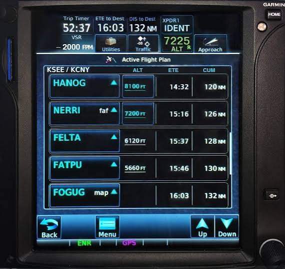
@Jackk's question made me think of this. I've seen the GTN 650 flight plan displayed on the G500/600 (emulation; picture). The result is an expanded screen with more of the waypoints displayed vertically and data displayed horizontally, Definitely makes a situational awareness difference. But I've never seen what the 430 displayed on glass looks like. So I wonder ... what does the 430 look like translated to the G500? Does it produce an expanded 430 screen, basically creating a 530-style presentation, or does it also translate it into the more modern Garmin visual interface like the one here? I can kind of see it happening either way.

-
I think the G500 is pretty much the same. And "large screen to display things coming from other places" a great way of looking at it.
-
I’m surprised by the third. Pretty sure the G3X charts are georeferenced and display position. Not surprised by the other two. Although it would be nice to be able to load an approach directly in the G3X in the off-case case of an emergency where everything works except the external navigator, I can see a reason for the lack of an instrument approach database in a VFR-only unit. Kinda part of #2 above. The view-only nature of the G3X flight plan display is, I think, a Garmin thing that appears in other combined PFD/MFD units. They don’t control the external navigator.
-
Not that uncommon to not like it. The theory is to be able to see weather and traffic at the same time. I use the feature but turn up the opacity of the plate. OTOH, when using Dynamic Procedures, I hide the plate altogether.
-

What altitude is the M20K 252/Encore certified for?
midlifeflyer replied to Fix's topic in M20K Owners
"Typical" is right. All AI does is collect references from the Internet. And what's out there in the aviation space are online forums and Facebook groups where you will find far more wrong answers than correct ones. Basic GIGO. I see it all the time. Wrong answers. Answers that don't even relate the the question. -
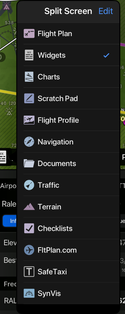
Side by side horizontal. Up and down vertical. And not only the chart. Garmin’s split screen can handle a multitude of functions. (see pic). An interesting one is widgets where you can display airport information. It’s even location sensitive. It’s a very elegant implementation of the concept Must be 10 years ago when my club had a presentation by Tyson. I ask that question. He asked me why and I said one reason was the ability to display the approach plate at the same time as the map. He replied, “I think we have a better idea for that coming along soon.” Turned out he was referring to plates over maps, which was still in development. Basically, FF chose to dedicate split screen to the SVT functionality.