

Scott Dennstaedt, PhD
-
Posts
456 -
Joined
-
Last visited
-
Days Won
3
Content Type
Profiles
Forums
Blogs
Gallery
Downloads
Media Demo
Events
Posts posted by Scott Dennstaedt, PhD
-
-
2 hours ago, Danb said:
I couldn’t agree more great wx product, Scott continues to improve it..his book on weather is great also unfortunately I got mine before the ebook came out and they didn’t seem to offer those who bought the paperback an e book at a discounted price.
Dan,
Thanks. I sent out an email to everyone who purchased a physical book to add the ebook for $39.95. Did you check your spam folder? If not check your private message in a little bit.
-
 1
1
-
-
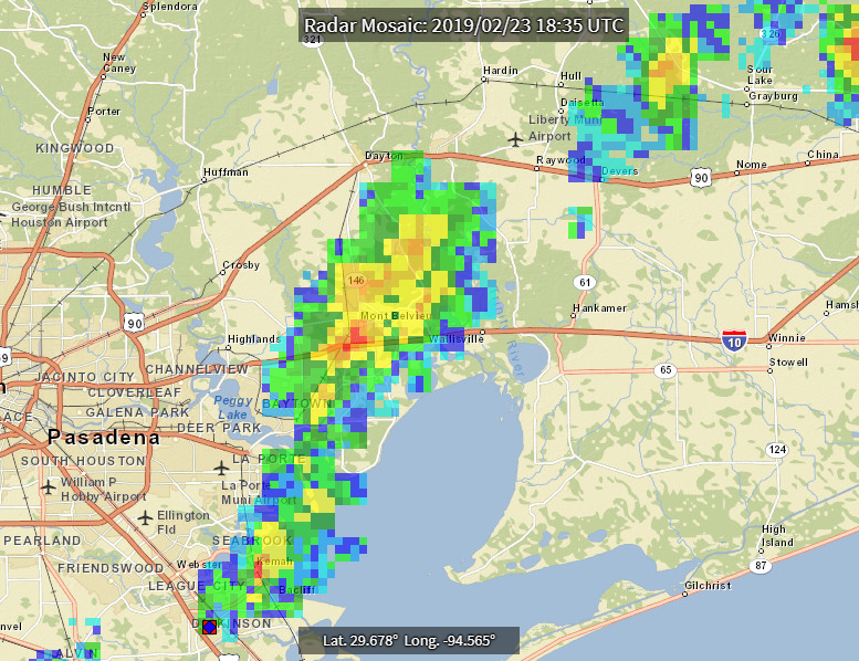
Here's the radar depiction just as Flightaware was showing a 7000 ft drop about 1238 CST.
-
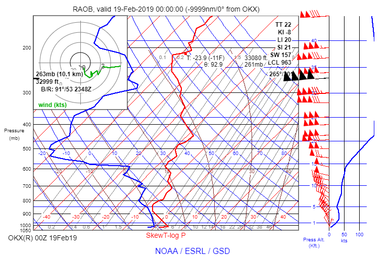
Here's the RAOB that they used to determine the 201 knot wind (231 mph). It was at 33,000 feet.
-
11 hours ago, carusoam said:
Erik was discussing a theoretical flight planning session...
Flying a Mooney in the lower flight levels and achieving the greatest X-country groundspeeds possible...
A good portion of the challenge is predicting the location and the strength of the jetstream winds....
Then to follow the planning, how would he navigate and maneuver to stay in the jet stream the whole way... getting winds aloft at 20k’ while flying....
A typical Sea to shining Sea flight starts near LA and ends near Atlanta....
Got any ideas? Insight on Jetstream tracking, or seasonal strengths?
Just a PP thinking out loud... i’m Usually looking at specific locations to avoid strong winds... this is the exact opposite...
")
Thanks in advance and best regards,
-a-
Theoretically it's very easy. It's an optimization problem to maximize your groundspeed based on the forecast winds aloft. You'd have to limit the altitude by the service ceiling or oxygen requirements. But again, that's easy. Practically, it's not so easy as there are weather barriers that will create a less than optimal route on most days. We're looking at the best wind alternative now in WeatherSpork that will also include weather routing based on forecasts. But that's a ways off.
-
2
-
-
2 hours ago, carusoam said:
Start assembling the MS team...
It may help to have a weather guy...
to best plan for the best winds...
@scottd got time for an interesting wind question?
Best regards,
-a-
What’s your question?
-
25 minutes ago, Hank said:
"Ice pellets"? Not hail or sleet, but ice pellets? What's the deal with that?
Sleet is the colloquial term. Ice pellets are produced through a different process than hail. Ice pellets are a great indicator of SLD aloft as I will be explaining at my live webinar in March.
-
2
-
-
7 minutes ago, M20F said:
Instead choosing the easy way with a math degree. Everyone knows 1+1=2 but who really understands a slew-t chart.
What's a slew-t chart? Ah, a sKew-t chart.

-
13 minutes ago, aviatoreb said:
I LOVE your posts Scott. I always loved weather, since I was a little kid and my mom let me stay in the garage with the door open listening to thunderstorms. You are the weather geek I had thought of becoming myself at some point heading off to college. :-)
So I have heard (rarely) thunder-snow around here in upstate NY. I have never seen thunder snow-lightning but I think that is due to the obscuring effect of the snow.
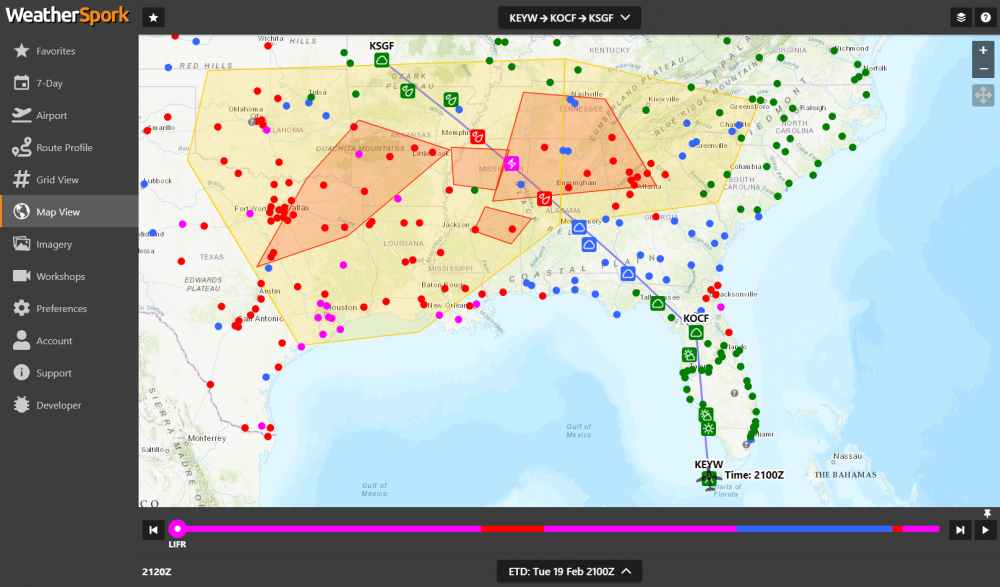
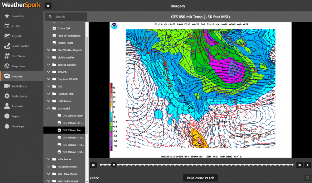
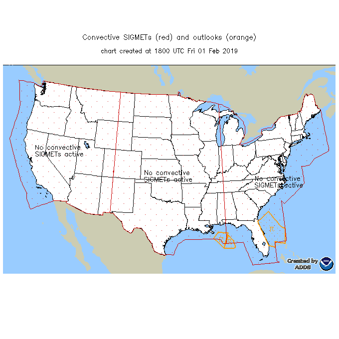
Pretty amazing area of thunderstorms here that spans a very large area. Here are the convective SIGMETs (red polygons) shown in WeatherSpork and the yellow area is the convective outlook.
Why is this amazing? Not because it's in the middle of February and there's thunderstorms, but because there really isn't any instability in the regions where convection is now occurring as indicated by the most unstable CAPE chart below.
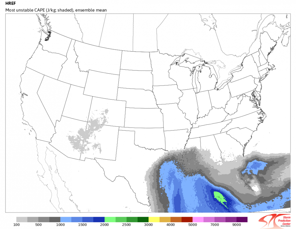
It's all in association to a very large high amplitude upper level trough moving in from the west.
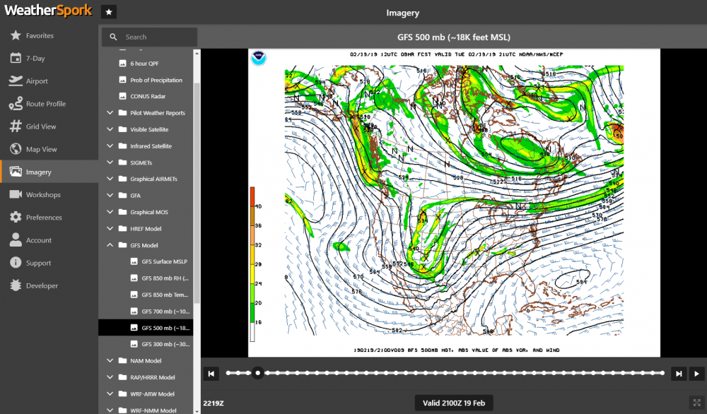
There's this cold wedge of air sitting up over the lower Mississippi and Tennessee Valley area. If you look at the surface winds through Tennessee, northern Alabama, northern Mississippi, they are all out of the east bringing in some very cold, moist air as air flows clockwise around the high pressure in the east.
Then, if you go up to 5,000 feet (850 mb) below notice the wind direction...from the south over the Gulf coast states. Even some winds as much as 50 knots. We call this isentropic lift as that warm air moves up and over the dense air at the surface. So essentially this air is riding up on the density discontinuity.
-
1
-
-
Temperature 3°C at the surface and thunder.
KCHA 192053Z 35011KT 2SM TSRA BR SCT007 SCT015CB OVC060 03/02 A3040 RMK AO2 TSB35 SLP296 OCNL LTGIC SW-N TS SW-N MOV NE
Translated: YUK!
-
On 2/14/2019 at 4:14 PM, Jeff_S said:
Thanks Scott. That blog I think explains it, as well as confirms some suspicions I've had for awhile about mysterious lack of returns. The weather forecast for the whole day was for negligible precipitation and no convective activity, so it seems reasonable that the human-element may have set this filter and then not turned it off when showers started to develop.
Jeff,
The part that is a shame is that they filter the mosaic. I'd personally rather see an unfiltered depiction. Yes, it will have ground clutter and anomalous propagation on it, but it'll also show you the location of gust fronts and outflow boundaries that are currently filtered out. And it won't miss these events.
-
1
-
-
6 hours ago, carusoam said:
See if we can invite our weather MSer to the conversation... @scottd
Scott May have some insight on the XM broadcast challenges...
I can't be sure without doing some detailed investigation and getting TWC (formally WSI) involved to find out. However, it smells like an issue that isn't all that common, but not all that rare. I discuss this here in my new AvWxTraining blog (feel free to join my blog - its free and you'll get notified of new posts). Also if you are an AvWxWorkshops/WeatherSpork member, I discuss this issue also in one of my bite-sized member workshops here.
-
1
-
-
FZUP - some kind of unknown freezing precipitation I guess. Or someone FZ'ed it UP!

-
1 hour ago, Marauder said:
Scott - how much information is supposed to be reported on a MOS for an airport that has no weather reporting?
Below is the MOS for my home airport. Is this supposed to be a composite of nearby weather reporting stations extrapolated for my airport?
Sent from my iPad using Tapatalk ProIf there’s no weather reports, you won’t see a MOS forecast. Likely they may be using the nearest MOS for this airport.
MOS is more than extrapolation. Here’s a video that explains more about MOS.
-
2
-
-
There was a change of some government URLs are now requiring https vs http. It likely has something to do with that.
-
2
-
-
On 2/2/2019 at 11:23 PM, flyboy0681 said:
While there may not have been a SIGMET issued, it doesn't mean that there wasn't isolated weather in the area.
That's a good point and the reason I mentioned it. Too many pilots (and briefers) tend to overlook that. Understanding the criteria for when a convective SIGMET is issued is critical. There doesn't have to be a convective SIGMET for an area of convection to be extremely dangerous. Plus there were a ton of other clues in that TAF pilots need to learn how to interpret.
-
On 2/2/2019 at 10:53 PM, M016576 said:
I see one major possible cause here.... reading alone doesn’t necessarily paint the picture.
how many people use their EFB alone as their “weather brief”? I’ve seen it on you tube videos... people have stated so much on this website... and I’ve been guilty of it too...
but when real weather is out there. Storms, layers.. pretty much anything that is painted on a radar... a pilot *NEEDS* to talk to a weather briefer. Some do. Some don’t. But they all should (myself included). Because the TAF’s alone, and radar picture alone don’t REALLY paint the total picture.
To think any of us can make an objective decision without the total picture... it’s short sighted at the very least. Complacent and arrogant at the worst.
*****I personally don’t know if this pilot did or did not call for a weather brief... just a suspicion... this rant is more due to some of the things I’ve subjectively noticed on beechtalk, YouTube, here.. other pilot internet sources... seems like pilots don’t seem to value a real briefer much anymore... had too many friends fall to preventable mishaps in aviation... don’t want to see any others. Especially in GA- where this is supposed to be FUN! and safe.********
I agree that the big picture is the most important. I make most of my decisions to go or stay based on that big picture, not the details.
I don't talk to a briefer any more except to get NOTAMs or file a PIREP or flight plan. Primarily because they don't provide (or are allowed to provide) some of the higher temporal and spatial resolution tools that are now available and have been for over a decade. They basically stick to a script (defined in AC 00-45H Change 1) which works very well when the weather is extremely challenging (no fool would launch) or extremely benign (even the most junior pilot would launch). It's that "in between" weather scenario where I've seen a briefer provide less than stellar information. In the end, it comes down to understanding how the forecasts and observations should be interpreted. What does SHRA (rain showers) really mean if the visibility is 5 statute miles? Does that WS020/18045KT (non-convective LLWS) mean a really bad ride for my early morning flight? The briefer isn't going to tell you that...in fact, in my experience they are more likely interpret it the wrong way.
There's no harm to call a briefer. Just be aware, there are open manholes in that briefing. When I do one-on-one training with a student for a trip that he or she is about to take, I often take about an hour. Most telephone briefings are typically less than 10 minutes (maybe 15). That's simply not enough time to get a true sense of all of the factors that should play into your decision. Plus, the briefing is a very single threaded approach. You provide a departure time (and other stuff) and then you get flooded with weather data. Instead, I like to look at all possible departures over the next few days and see which time gives me the best opportunity to minimize my exposure to adverse weather. Once I have that time (assuming it fits in my schedule), then I drill down to understand the details.
-
1
-
-
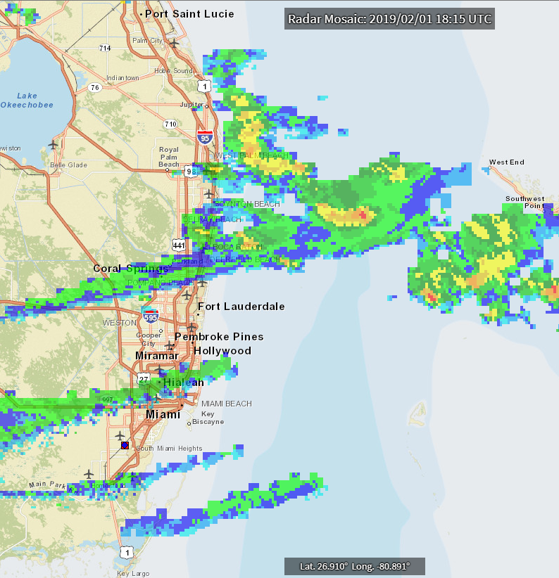
11 hours ago, flyboy0681 said:
This story appeared in the local paper. Anybody with access to a local radar picture would have known to stay clear away from this.
Perhaps, but based on the thousands of pilots I've trained over the last 20 years, there's a lot more to the story when you dig deep. In this case there were thunderstorms in the area.
Here's the 17Z observation:
KPBI 011653Z 12003KT BKN045 BKN060 21/20 A3021 RMK AO2 RAE40 SLP229 CB E-SE MOV N CB DSNT S P0001 T02060200
And the 18Z observation:
KPBI 011822Z 00000KT RA BR SCT012 BKN041 21/20 A3017 RMK AO2 CB OHD-NE-E MOV N CB DSNT NE SE P0006 T02110200
Here's the TAF for nearby PBI -
KPBI 011459Z 0115/0212 VCSH SCT025
      TEMPO 0115/0117 SHRA
     FM012200 07008KT VCSH SCT020 BKN050
     FM020400 11010KT SCT020 BKN070
I wish this pilot had attended my most recent webinar. The TAF above clearly illustrates the dangers he was facing - but few pilots know how to interpret this (and no, it's not about decoding the TAF, but understanding the threats clearly depicted.
I wish that more pilots would read the AFD...it has so much good info most of the time...it clearly indicates the potential for embedded convection.
.AVIATION...
Convection associated with a weak frontal boundary meandering
across South Florida's Atlantic waters will continue to create
periods of sub-VFR conditions over the next day or so. PBI is the
terminal most likely to be impacted this afternoon with MVFR or
brief bouts of IFR/LIFR conditions possible. Low cigs/fog is
possible overnight, mainly in SW Florida and over the interior,
which will possible affect APF into Saturday morning. Additional
convection on Saturday could again create sub-VFR conditions
mainly along the east coast.

The route was on the southern edge of a convective outlook area, but there wasn't a convective SIGMET issued because the convection did NOT meet SIGMET criteria.
The news story said he flew into a severe thunderstorm. There wasn't a severe thunderstorm in this area. Ugh!
-
Implementation of Terminal Aerodrome Forecast (TAF) Service for: KCOT, Cotulla-La Salle County Airport Cotulla, TX will start effective April 15, 2019.
-
...the entire atmosphere from 5,000 feet to 50,000 feet is nearly isothermal (a lapse rate of zero) as it is here for the 00Z radiosonde launch from Minneapolis.

-
5
-
-
Was doing a one-on-one session with a customer yesterday who was planning a flight from Florida northbound to Asheville, NC (KAVL). His plan was to depart this morning around 9 am for a 2.5 hour flight. Mostly VFR conditions (green) expected along this route until reaching the Georgia where IFR (red) and low IFR (magenta) could be possible.
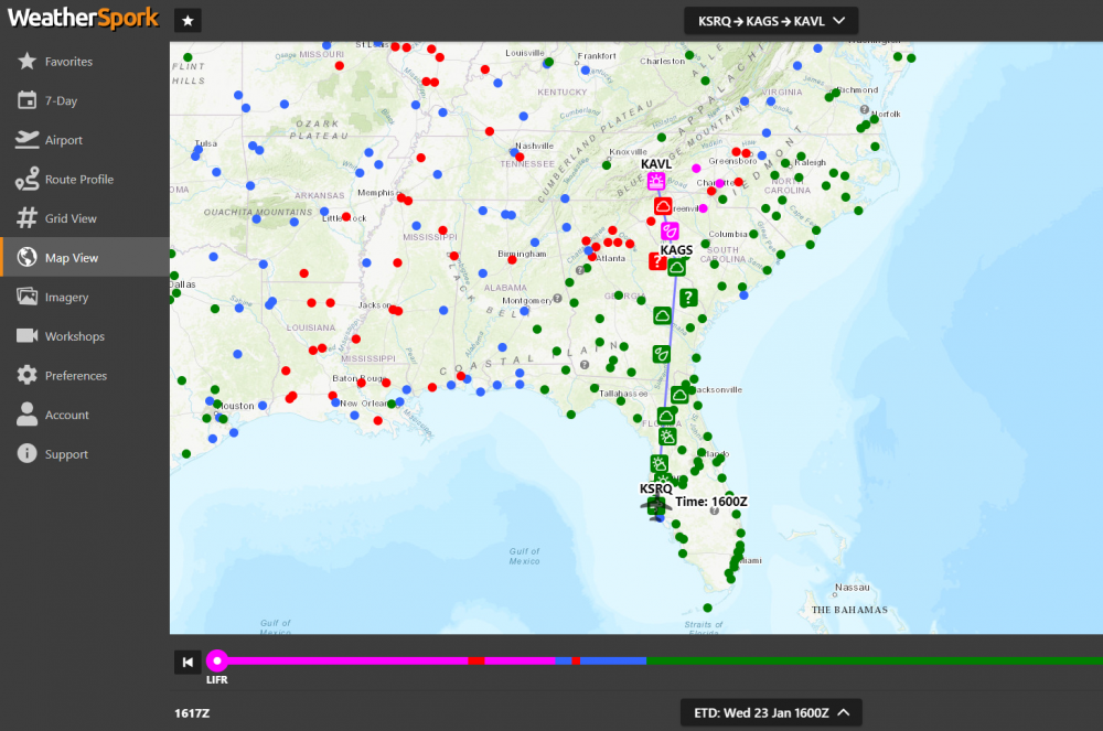
The flight was planned well ahead of a major weather system moving in from the west, so no issues there. However, with cold air in place near the surface over the Piedmont of NC and SC, the chances of some freezing precipitation were expected ahead of the primary weather system as warm air from the south was overrunning the cold air at the surface. This was expected to give rise to a temperature inversion and multiple freezing levels as shown below (screenshot taken yesterday during the online session).
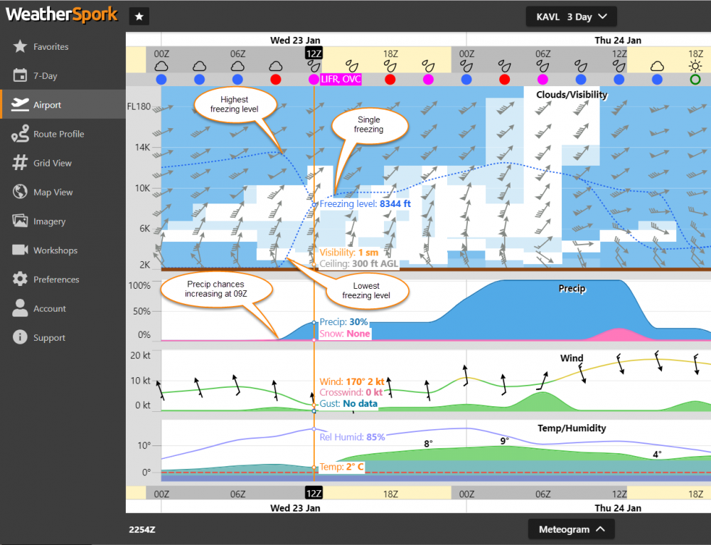
Notice above that about 09Z, multiple freezing levels exist in this meteogram view for Asheville and then by 12Z, the warm air takes over aloft and creates a single freezing level after 12Z. The precipitation chances are shown as ramping up around 09Z as well with low IFR conditions (300 ft, 1SM) at Asheville at 12Z. This sets the stage for a freezing rain (or freezing drizzle) event with LIFR conditions at Asheville. So this certainly solidified the plan to wait a couple hours after 12Z to arrive in Asheville. Note this aircraft has a TKS certified ice protection system.
Below, the Asheville TAF, on the other hand, has some freezing rain probabilities from 01Z through 12Z with MVFR ceilings and vis through the period. So, the forecasts above and the TAF agree that the freezing rain is expected to end at 12Z which is nicely represented in the route profile view above.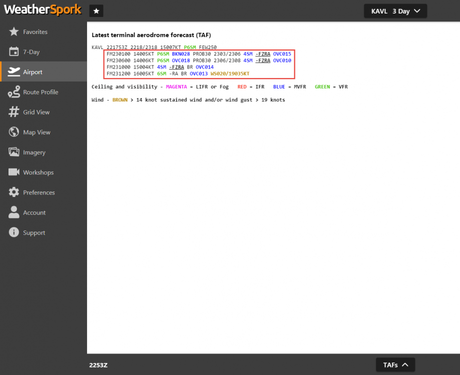
Now that we can look at the observations, let's see how well the forecast above did versus the TAF. Here are the surface observations for KAVL from 01Z (at the bottom) onward. I've removed some of the remarks to keep the coded observations short.
KAVL 231454Z 17003KT 3/4SM BR OVC003 01/M01 A3028
KAVL 231449Z 17003KT 3/4SM BR OVC003 01/M01 A3028
KAVL 231419Z 00000KT 1 1/4SM BR OVC004 01/M01 A3028
KAVL 231354Z 00000KT 1 1/2SM BR OVC004 01/M01 A3029
KAVL 231349Z 00000KT 1 1/2SM BR OVC003 00/M01 A3028 R
KAVL 231341Z 00000KT 1 1/4SM -FZRA BR OVC003 00/M01 A3028
KAVL 231331Z 00000KT 1 1/4SM -FZRA BR OVC002 00/M01 A3028
KAVL 231305Z 00000KT 1 1/4SM -FZRA BR OVC003 00/M01 A3028
KAVL 231254Z 16003KT 2SM -FZRA BR OVC003 00/M01 A3028 RMK AO2 UPE40FZRAB40
KAVL 231246Z 18003KT 2 1/2SM -FZRA BR OVC004 00/M01 A3029 RMK AO2 UPE40FZRAB40 CIG 002V007
KAVL 231239Z 18003KT 2SM UP BR OVC004 M01/M01 A3029 RMK AO2 CIG 002V008
KAVL 231224Z 18004KT 1 3/4SM UP BR BKN003 OVC007 M01/M01 A3029 RMK AO2 CIG 002V005
KAVL 231220Z 18004KT 2SM UP BR OVC005 M01/M02 A3029 RMK AO2 CIG 002V008
KAVL 231154Z 00000KT 3SM UP BR OVC008 M01/M02 A3029 RMK AO2 CIG 003V009
KAVL 231054Z AUTO 22003KT 3SM UP BR OVC007 M01/M02 A3032
KAVL 231020Z AUTO 00000KT 3SM UP BR OVC009 M01/M02 A3032 RMK AO2 CIG 004V010
KAVL 230954Z AUTO 00000KT 5SM UP BR OVC010 M01/M02 A3034
KAVL 230943Z AUTO 00000KT 4SM UP BR OVC009 M01/M03 A3035
KAVL 230854Z AUTO 00000KT 9SM OVC010 M01/M03 A3036 RMK AO2 UPB08E44
KAVL 230754Z AUTO 11003KT 10SM OVC014 M01/M06 A3040 RMK AO2 UPE42
KAVL 230654Z AUTO 14004KT 10SM UP OVC016 M01/M09 A3041 RMK AO2 UPB20
KAVL 230554Z AUTO 14004KT 10SM OVC018 00/M12 A3043
KAVL 230454Z AUTO 16004KT 10SM OVC021 01/M13 A3046
KAVL 230354Z AUTO 14007KT 10SM OVC023 01/M13 A3047
KAVL 230254Z 14004KT 10SM OVC026 01/M14 A3048
KAVL 230208Z VRB03KT 10SM OVC029 01/M14 A3048
KAVL 230154Z 16004KT 10SM OVC030 01/M14 A3048
KAVL 230112Z 14003KT 10SM OVC031 01/M13 A3048
KAVL 230054Z 16004KT 10SM OVC029 01/M14 A3048
Using the observations, the first indication of any precipitation wasn't until 07Z with UP (unknown precipitation type). Likely freezing drizzle occurring (an ASOS can't automatically report freezing drizzle and likely reports it as UP). Then at 0943Z, more UP. The TAF only showed a 30% probability of freezing rain through 08Z whereas the forecast we used above showed a 0% chance up to 09Z. Then, notice the freezing rain actually was first reported at 1246Z and last reported at 1341Z as the temperature warmed to above freezing by the 14Z observation.
The biggest difference was in the ceiling forecast. The forecast we used above had the flight category in the IFR range by 09Z and then LIFR at 12Z. The actual ceilings dropped from VFR at 01Z to IFR by 0945Z. Then by 1224Z, KAVL reported a ceiling of 300 ft. The forecast we used picked up on this trend really well and was much better overall guidance than the TAF. At this point in time KAVL is reporting very LIFR conditions and the pilot smartly diverted to Greenville Downtown (GMU) which was an expected outcome due to the potential of LIFR when we looked at alternates yesterday.
KAVL 231601Z 16008KT 1/2SM FG VV002 01/00 A3022
Overall, the tools we used did a pretty nice job showing the overall adverse weather hazard trends and allowed the pilot to plan a solid alternate accordingly.-
3
-
-
5 hours ago, Bob - S50 said:
For both sites you have to use airports that it recognizes. In general, any airport that gets a TAF plus a few more.
Actually the usairnet site is just the GFS MOS (in graphical form) and it has about 2200 airports vs 660 TAF sites in the U.S.
-
Looks like a smooth day up there in the flight levels!
-
15 minutes ago, exM20K said:
Scott,
when you do a kindle version, please do a “true” kindle ebook, and not a pdf/image upload. I’ve bought a couple (Mike Busch’s engines book for example) that were pdf or image uploads from the print version. The resulting print was so small and not resizable on the kindle, that I had to revert to the iPad. The book was otherwise excellent, but the delivery frustrating.
-dan
That's what we are working to do Dan. It's pretty costly given all of the "conversions" that need to occur to get it right. It'll be converted to Kindle and ePub (One ePUB file will work on Apple iBooks, Barnes & Noble eBook Reader, Kobo Reader, Google).
-
1
-
-
2 hours ago, Jim Peace said:
Weather? LOL....speaking as a cargo pilot unless some visibility issues dealing with legalities or a tornado you're going anyway... if you do not at least attempt to go at my company they start with a termination hearing and that is where you may prove your case...
We’ve had a couple dozen pilots buy the book who fly for the airlines. Doesn’t mean if you are a professional pilot you can’t learn about weather to make better decisions in flight.


WeatherSpork
in Miscellaneous Aviation Talk
Posted
Wonderful feedback! It's extra nice when the weather cooperates with the app.