Neshi Posted June 13, 2020 Report Share Posted June 13, 2020 Just looking at some approaches in my area and found that a GPX X Runway 10 was added to HTO. What I'm confused about is why would anybody use this approach? As the Zulu has lower minimums and less restrictions. https://skyvector.com/files/tpp/2006/pdf/05016RX10.PDF https://skyvector.com/files/tpp/2006/pdf/05016RZ10.PDF Quote Link to comment Share on other sites More sharing options...
carusoam Posted June 13, 2020 Report Share Posted June 13, 2020 For questions like that... I go to @midlifeflyer to borrow his east coast reasoning.... Line up both plates side by side... Read every plate line by line... Something seems to be hidden in there for why you would have two different GPS plates for the same runway? They use different fix names IAF, FAF... Best regards, -a- Quote Link to comment Share on other sites More sharing options...
midlifeflyer Posted June 13, 2020 Report Share Posted June 13, 2020 9 hours ago, carusoam said: For questions like that... I go to @midlifeflyer to borrow his east coast reasoning.... Line up both plates side by side... Read every plate line by line... Something seems to be hidden in there for why you would have two different GPS plates for the same runway? They use different fix names IAF, FAF... Best regards, -a- Actually, there are three different GPS plates for the same runway. Z, Y, & X. Z and Y are different in that Z only has APV minimums while Y only has LNAV minimums. I really have no idea but my guess is there is something along the extended FAC which means that aircraft must (sometimes?) remain higher closer to the airport and have a much higher angle of descent. 1 1 Quote Link to comment Share on other sites More sharing options...
bradp Posted June 13, 2020 Report Share Posted June 13, 2020 If you want the terps details post the same question over on the IFR sub forum of beechtalk- a terps expert Wally Roberts will chime in and tell you all about the obstructions. 1 2 Quote Link to comment Share on other sites More sharing options...
takair Posted June 13, 2020 Report Share Posted June 13, 2020 My guess is noise, noise, noise. The X is steeper, likely intended for helicopters. They have ongoing noise disputes in the Hamptons. This may be the preferred approach “in season”, when weather permits, and the aircraft is able. 1 Quote Link to comment Share on other sites More sharing options...
PT20J Posted June 14, 2020 Report Share Posted June 14, 2020 If you are arriving from the west, MATHW is an IAF and you won’t have to do the course reversal at the IF/IAF. The differences in minimums will be due to obstacles. Wally would have the details. Skip Quote Link to comment Share on other sites More sharing options...
Garryowen Posted June 14, 2020 Report Share Posted June 14, 2020 The 4.2deg glides slope is the big difference. A while back the township refused to cut the trees for the clear way on the approach to 10 and the Zulu was notam'd out. They came up with the steeper X-ray so you could still get in. Even visual approaches at night were not allowed because of the trees and the vgsi being set for around 3.3deg. Lots of politics for a "small town" airport. 2 1 Quote Link to comment Share on other sites More sharing options...
midlifeflyer Posted June 14, 2020 Report Share Posted June 14, 2020 8 hours ago, PT20J said: If you are arriving from the west, MATHW is an IAF and you won’t have to do the course reversal at the IF/IAF. The differences in minimums will be due to obstacles. Wally would have the details. Skip The lateral FAC is identical for all three approaches, so the obstacles are exactly the same. If you are coming from the west, you are almost surely going to be cleared straight in and extremely unlikely to do the course reversal even on the ones which are not NoPT. Yet for some reason, one keeps you higher longer resulting in a relative dive on the FAC. Missed is the same. None has a TAA or a different equipment requirement. Even the separation of lateral only and APV minimums into separate approaches (the Z and Y) is unusual. That's why I used the word "sometimes" in my speculation. I just didn't see any of the usual indicators for two different approaches serving the same runway. I suspect @Garryowen's politics answer may be closer to the reality than a TERPS analysis. Quote Link to comment Share on other sites More sharing options...
takair Posted June 14, 2020 Report Share Posted June 14, 2020 Gary’s answer makes a lot of sense and it all comes back to noise. This airport is under constant risk due to noise. Google the airport and all the discussion on noise and it becomes clear that some of the locals will be motivated to block anyThing that might increase traffic. In general, the only obstacles out there are trees and mansions.....but neither are very compatible with low flying aircraft. Quote Link to comment Share on other sites More sharing options...
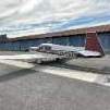
Garryowen Posted June 14, 2020 Report Share Posted June 14, 2020 Not the best photo but it’s the most recent one I have. It’s really a postage stamp of an airport and sometimes the ceiling and vis gets pretty low. I’ve had more than one occasion of an LPV to minimums that have resulted in a missed approach. You can see the approach to 10 and what the clearway looks like now. If I remember right it took about 9 months for the X-ray to come out after the Y was shutdown for encroachment issues. Not surprisingly the trees were cut shortly thereafter as the politicians sought other ways to reduce traffic. One clever tactic the local pols used was to withhold funds to fix runway and taxiway lights. Needless to say the feds got involved in that one. Something about federal money to a public use airport and safety of flight trumped local politics. Quote Link to comment Share on other sites More sharing options...
Recommended Posts
Join the conversation
You can post now and register later. If you have an account, sign in now to post with your account.