Scott Dennstaedt, PhD
-
Posts
437 -
Joined
-
Last visited
-
Days Won
3
Content Type
Profiles
Forums
Blogs
Gallery
Downloads
Media Demo
Events
Everything posted by Scott Dennstaedt, PhD
-
 Just a quick reminder that the SUN 'n FUN Daily Weather Roundup live stream starts this Wednesday at 3 pm EDT.
 -
For those interested, my Daily Weather Roundup for SUN 'n FUN starts next week on Wednesday, March 30th. Join me live on the EZWxBrief YouTube channel beginning at 3 pm eastern time. If you are flying you may want to watch each day to gain a better appreciation of the weather challenges that you may face flying to the event. Even if you are not flying to SUN 'n FUN or even attending the event, it may be an educational opportunity to learn how to interpret medium- to long-range forecasts. Each daily broadcast will be 20 to 30 minutes long and that includes a broadcast on Saturday and Sunday at the same time. The last live broadcast will be on Monday, April 4th. They will be recorded and available on the same YouTube channel shortly after the broadcast ends. At the moment, the GFS model is predicting a potent upper-level trough moving out of the southern Rockies on Wednesday morning, but a ridge dominates most of the eastern U.S. during the early part of the week providing for nice weather in that area. This is more than 10 days out, so there's a lot of uncertainty here in this forecast.
-
Some of you may remember the A.M. Weather program that was broadcast every morning from Owings Mills, Maryland through Maryland Public Television. Hopefully my rendition won’t tarnish its legacy.
-
Nice to hear. I have been offering that service for about 15 years. I do 1-on-1 online training...not acting as your briefer or providing a dispatch service, but teaching you how to properly do a route-based briefing, but you will walk away with an outstanding view of what to expect on your flight.
-
It's a work in progress that will evolve over time.
-
For those that may be interested, this week I started broadcasting a daily weather brief every morning at 7 a.m. eastern time on YouTube Live. The goal is to provide general aviation pilots with a brief weather overview of today's weather impacts across the conterminous U.S. and southern Canada. It is being recorded and will be available on the EZWxBrief YouTube channel shortly after the live broadcast. Click here to view today's Daily EZ Weather Brief. Whether you are flying today or not, I hope you can tune in each day to watch. Please note that this video is being freely offered for educational and entertainment purposes only and should not substitute as a formal weather briefing as required by 14 CFR 91.103.
-
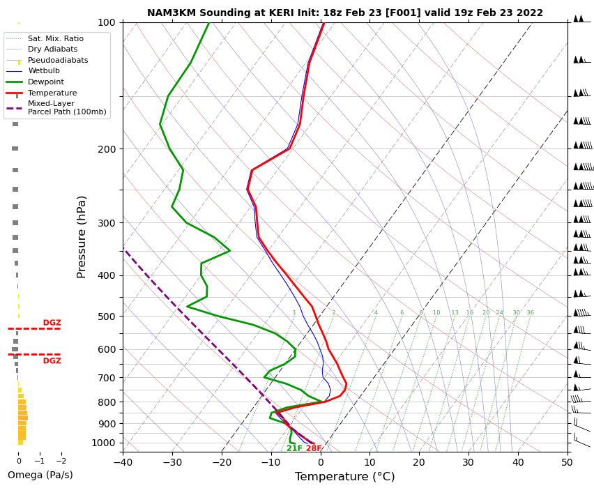
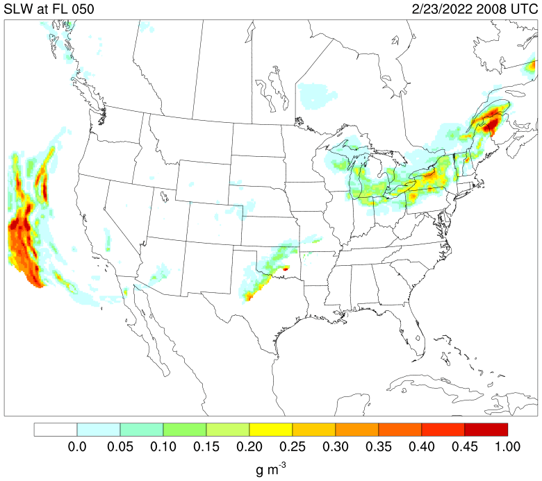
Norm, Appears you descended through a stratocu deck into Erie. These clouds tend to have a high liquid water content near the tops especially in the warmer subfreezing temperature regime. With snow on the ground in Erie, it's even more likely you'll run into larger drop sizes. KERI 232024Z AUTO 31011G17KT 1 3/4SM -SN SCT013 BKN018 OVC024 M03/M07 A3036 RMK AO2 SNB1958 P0000 T10331067 KERI 231951Z 32012G16KT 10SM BKN017 OVC024 M02/M07 A3034 RMK AO2 SNB26E37 SLP284 P0000 T10221067 KERI 231851Z 30013KT 10SM OVC015 M02/M07 A3033 RMK AO2 SNE32 SLP278 P0000 T10221067 The NAM forecast valid at 19Z shows that fairly warm cloud tops were likely around 6,000 ft MSL. The clouds tended to deepen a bit to maybe 7,000 ft by 20Z. In this area it's not unusual sometimes to see high liquid water content right at the top of that inversion (~5,000 ft) even if snow is reaching the surface. With deeper systems (> 12,000 feet) from lake effect snow, it's not unusual to see even drizzle-sized drops at the tops. In fact, there was a fairly high area of supercooled liquid water contents at 5,000 feet along the last part of your route. This is about 0.2 to 0.25 g/m^3 which is pretty high.
.png.547bfb31158ce9851815dbb1b04fa68c.png)
-
Weather chart quiz
Scott Dennstaedt, PhD replied to Scott Dennstaedt, PhD's topic in Miscellaneous Aviation Talk
Yes, B is the correct answer. This area is a forecast for a 55% or greater likelihood of non-convective rain reaching the surface at the valid time on the chart. As I discuss in my Pilots Guide on page 115, this is non-convective rain expected at the surface at the valid time on the chart. This defines precipitation coverage. The colors represent a likelihood forecast not a calibrated probability, however. Dark colors represent a 55% or greater likelihood this will occur at the valid time on the chart. For those interested, please read my recent blog post that will provide more details. -
Weather chart quiz
Scott Dennstaedt, PhD replied to Scott Dennstaedt, PhD's topic in Miscellaneous Aviation Talk
Ah yes...and the reason for the question. You fell into my trap Dan. -
Weather chart quiz
Scott Dennstaedt, PhD replied to Scott Dennstaedt, PhD's topic in Miscellaneous Aviation Talk
Yes, that is correct. But there is a reason for this. I discuss that in one of my YouTube videos that discusses these progs charts. You can view it here. I apologize for the audio...my other microphone I normally use was TU when I made this video. Having said that, this is just an administrative aspect of how this chart is created, but does not drive the answer to the original question on how this area in northwestern GA should be interpreted. -
On the short range prog chart below, what does the dark green color depicted over northwestern Georgia imply? A - A forecast for the likelihood of moderate to heavy non-convective rain over a six hour period ending at the valid time on the chart B - A forecast for a 55% or greater likelihood of non-convective rain reaching the surface at the valid time on the chart C - A forecast for non-convective heavy rain over a 12 hour period beginning at the valid time on the chart D - None of the above

-
The NTSB prelim report can be found here. Nothing revealing at this point.
-
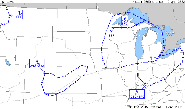
Just to be clear, this particular radiosonde observation showed that the static air temperature at ~8,000 feet was +2°C. And then cooling to 0°C at ~9,000 feet. This observation was approximately 100 nm northeast of the accident site. Near the accident site, the temperatures were warmer such that the freezing level was nearly 12,000 feet. So any aircraft taking off and climbing in this environment would have not accreted or expect to accrete any airframe ice. Eventually as the flight headed west toward Denver, the freezing level was trending lower and would have been below freezing upon reaching the KC area...even so, the amount of moisture at 8,000 feet was negligible in the KC region. It's not until the last third of of the flight where icing conditions would have been problematic as can be seen by this G-AIRMET valid at 03Z.
-
Yes, the kinetic heating primarily due to adiabatic compression has a much greater effect on the boundary layer temperature of the air just above the leading edge surface. That's why you see the total air temperature to be several degrees warmer than the static air temperature. He says, "Myth-Aircraft structural icing only occurs in freezing temperatures. Fact-Aircraft structural icing can occur in outside air temperatures (OAT) up to +5°C, most commonly occurring in temperatures between +2°C and -20°C. A common cause for this is that the aircraft is descending from subfreezing temperatures into warmer air. The airframe may remain colder than freezing for a period of time after exiting the colder temperatures." This is so misleading. Yes, a cold-soaked aircraft can accrete some ice in the situation he describes. But the thermal momentum of the static air temperature of > 0°C on a descent coupled with the kinetic heating makes this a six-sigma event that has never caused any aircraft accidents or incidents. He's pulling at straws here. It's like you need all the planets to align for this to occur, so it's something we should worry about. The Current and Forecast Icing Products do not consider icing at static air temperatures above freezing.
-
Didn't read the article, but there's never been any aircraft accident related to this. If you can point out one, I'd love to see it. This isn't one of them. There's also kinetic heating which can cause an increase in temperature on the leading edge where icing is most likely to accrete. This is called total air temperature. We see this clearly when you look at how ice accretions form on the leading edge. I had a long conversation many years ago with one of the lead test pilots out of the NASA Glenn research center in Cleveland and he's never heard of any issues in this area. This aircraft was also warm-soaked at temperatures nearly 11°C in the climb, so the thermal momentum would keep the wings rather clean and it's likely icing would not accrete on the airframe until the static air temps were colder than -3°C.
-
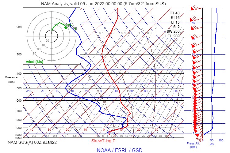
That's correct, thanks for chiming in - the RAOB was further to the northwest and the freezing level at that point was still 9,000 feet. If you look at the 00Z analysis from the NAM model just outside of SUS, the freezing level near the accident site was near 12,000 feet. As I mentioned in my blog post, the warm front was moving north, so the atmosphere was getting warmer with time. There's no chance of icing with this temperature profile.
-
Ah, I see. You are using the standard lapse rate instead of using the actual temps aloft (or forecast temps aloft). Not sure I understand why you'd do that. But what happens if the environmental lapse rate is greater than the standard? Then you've calculated the freezing level to be much higher than it actually is. No thanks. But, you do you. I'd rather use the actual/forecast temps aloft and make a much more informed decision. In this accident, the actual lapse rate was not 2°C/1000 feet, it was negative as I describe in this post. That put the freezing level above 9,000 feet MSL (likely near 11,000 feet). I teach all of my students, never, ever use the standard lapse rate for any meteorological decisions. The only time it's acceptable to use is to calculate the departure from standard for those POH/AFM performance tables.
-
So you don't fly in IMC when the temps are +11°C (or 52°F)? That's really interesting. I've been flying for 25+ years and never had any issues at those warmer temperatures in the clouds. I think you are the first to make that comment. I'm not saying there's anything wrong with that.
-
Hi Greg, There seems to have been a lot of people (based on the comments he received) that didn't go as far as you did with this...that is, believe there could be a temperature inversion. Just quite a shame that so many of his followers are being misled. No, I don't have any good sites to use that provides a truly historical model-based Skew-T. NASA did have one, but it seemed to stop working many years ago. At some point I will likely provide one on my site, but that's several years off (hopefully before I retire in about 7 years).
-
I got a bunch of emails from my students about this accident. It was largely driven by Dan Gryder's video. He has no doubt icing caused this accident. I don't know this guy and he evidently has a huge following. But, this guy doesn’t know what he’s talking about…please don’t follow him. He plays the ATIS at the time of departure which says the temperature is +7°C and then he says immediately after that, “…taking off into freezing drizzle.” Huh? First, you can’t have freezing drizzle at the surface with that warm of a temperature and second, there’s nothing in that ATIS that says anything about freezing drizzle or even precipitation. He then goes onto say that it gets colder as you go up. Yes, eventually it does get colder, but not at the altitudes the pilot was flying…it was actually getting warmer. Evidently this guy has never heard about temperature inversions. Ugh! That’s why so many pilots get really screwed up when it comes to making weather decisions since they listen to guys like this. This video has gotten almost 50,000 views already…just insane. If you want an accurate analysis, please visit my blog and read this post.
- 27 replies
-
- 10
-

-

-
This was yesterday. Based on the radiosonde observation (RAOB) out of Nashville, the temperature was closer to -27°C, but still pretty darn cold. This was in an area of dissipating convection which certainly explains the icing down to much colder temps.

-
IFR training questions and advice.
Scott Dennstaedt, PhD replied to Mcstealth's topic in Miscellaneous Aviation Talk
You will quickly discover that weather becomes the biggest physical factor limiting your IFR flying activity. I have been working with instrument students teaching them weather for about 20 years now and at the end of the day, making good preflight and in flight decisions involves having a solid foundation in weather. -
Yes, here is the reference. I am very good friends with Ben Bernstein who is one of the authors and he helped co-author my Ice is NOT Nice series. Cober, S., Bernstein, B., Jeck, R., Hill, E., Isaac, G., Riley, J., & Shah, A. (2009). Data and analysis for the development of an engineering standard for supercooled large drop conditions. US Department of Transportation.
-
You can read more about this in my recent blog post.
-
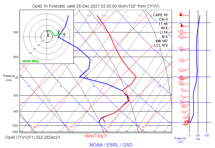
Yikes. Not a good night to be flying near Wiarton Keppel International Airport (CYVV). Non-classical SLD signature showing up on the forecast sounding.